Property Record
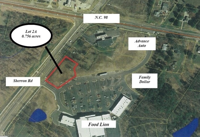
115 Sherron Rd, Durham, NC 27703

Property Detail
115 Sherron Rd
166191
PROP-RAVENSTONE COMMONS D EVE/TR#02/TR#02B PL:000178-000004
Storebuilding
DURHAM
CC(D)
North Carolina
B and X Area of moderate flood hazard, usually the area between the limits of the 100-year and 500-year floods.
1.22 AC
0
South Durham
2025
Raleigh/Durham
001808
Durham-Chapel Hill, NC
5,940 SF
NEARBY LISTINGS FOR SALE OR LEASE
DEMOGRAPHICS near 115 Sherron Rd
1 mile
3 mile
5 mile
2025 Total Population
4,917
31,623
96,938
2030 Population
5,224
33,626
103,634
Pop Growth 2025-2030
+ 6.24%
+ 6.33%
+ 6.91%
Average Age
39
40
39
2025 Total Households
1,800
12,059
38,860
HH Growth 2025-2030
+ 6.56%
+ 6.63%
+ 7.31%
Median Household Inc
$133,979
$109,459
$100,310
Avg Household Size
2.60
2.60
2.40
2025 Avg HH Vehicles
2.00
2.00
2.00
Median Home Value
$426,127
$386,297
$405,575
Median Year Built
2008
2007
2004
Nearby Places
Map Layers
Map Styles
 Street
 Aerial
Transit
 Traffic
 Biking
Places
Listings with unknown addresses are not visible on the map
- Restaurants
- Banks
- Shops
- Fitness
- Groceries
PUBLIC TRANSPORTATION
COMMUTER RAIL
Durham Amtrak Station (Carolinian - Amtrak, Piedmont - Amtrak)
Drive
Walk
Distance
Durham Amtrak Station (Carolinian - Amtrak, Piedmont - Amtrak)
15 min
6.9 mi
AIRPORT
Raleigh-Durham International
Drive
Walk
Distance
Raleigh-Durham International
19 min
10.5 mi
Freight Ports
Virginia Port Authority - Richmond
Drive
Walk
Distance
Virginia Port Authority - Richmond
168 min
145.1 mi
SALE & LEASE HISTORY
LISTING DATE
SALE/LEASE

Sep 24, 2016
For Sale
Nearby Properties
Address
Land Use
TOTAL SIZE
Lot Size
Zoning
Address
Land Use
TOTAL SIZE
Lot Size
Zoning
21.29 AC
CG(D)
Address
Land Use
TOTAL SIZE
Lot Size
Zoning
28,632 SF
23.64 AC
PDR 3.990
Address
Land Use
TOTAL SIZE
Lot Size
Zoning
13.70 AC
CG(D)
Address
Land Use
TOTAL SIZE
Lot Size
Zoning
12.33 AC
IP
Address
Land Use
TOTAL SIZE
Lot Size
Zoning
61,242 SF
8.59 AC
CC(D)
Address
Land Use
TOTAL SIZE
Lot Size
Zoning
53.25 AC
PDR 5.949
Address
Land Use
TOTAL SIZE
Lot Size
Zoning
131,114 SF
48.95 AC
RR
Address
Land Use
TOTAL SIZE
Lot Size
Zoning
80,330 SF
34.58 AC
RR
Address
Land Use
TOTAL SIZE
Lot Size
Zoning
53.96 AC
PDR 5.949
Address
Land Use
TOTAL SIZE
Lot Size
Zoning
181.12 AC
PDR 2.883
Address
Land Use
TOTAL SIZE
Lot Size
Zoning
98.34 AC
PDR 3.950
Address
Land Use
TOTAL SIZE
Lot Size
Zoning
82,777 SF
15.72 AC
RR,RS-20
Address
Land Use
TOTAL SIZE
Lot Size
Zoning
42.14 AC
PDR 4.680
Address
Land Use
TOTAL SIZE
Lot Size
Zoning
59,825 SF
9.03 AC
CC
Address
Land Use
TOTAL SIZE
Lot Size
Zoning
129.62 AC
PDR 3.551
Address
Land Use
TOTAL SIZE
Lot Size
Zoning
13,824 SF
3.55 AC
SPLIT
Address
Land Use
TOTAL SIZE
Lot Size
Zoning
215.61 AC
RR
Address
Land Use
TOTAL SIZE
Lot Size
Zoning
43.11 AC
PDR MH
Address
Land Use
TOTAL SIZE
Lot Size
Zoning
51,110 SF
0.86 AC
CG
Address
Land Use
TOTAL SIZE
Lot Size
Zoning
82.12 AC
PDR 2.903
Address
Land Use
TOTAL SIZE
Lot Size
Zoning
12,040 SF
1.79 AC
CN
Address
Land Use
TOTAL SIZE
Lot Size
Zoning
260.12 AC
RR
Address
Land Use
TOTAL SIZE
Lot Size
Zoning
18,180 SF
14.10 AC
IL(D)
Address
Land Use
TOTAL SIZE
Lot Size
Zoning
56,905 SF
4.17 AC
IL(D)
Address
Land Use
TOTAL SIZE
Lot Size
Zoning
36,232 SF
12.28 AC
PDR 0.000
Address
Land Use
TOTAL SIZE
Lot Size
Zoning
108.04 AC
RR
Address
Land Use
TOTAL SIZE
Lot Size
Zoning
47.50 AC
PDR 3.850
Address
Land Use
TOTAL SIZE
Lot Size
Zoning
17,105 SF
36.53 AC
RR
Address
Land Use
TOTAL SIZE
Lot Size
Zoning
25,001 SF
3.90 AC
PDR 1.630
Address
Land Use
TOTAL SIZE
Lot Size
Zoning
43.28 AC
RR
The World's #1 Commercial Real Estate Marketplace
Connect with us
© 2026 CoStar Group
The information above has been obtained from sources believed reliable. While we do not doubt its accuracy we have not verified it and make no guarantee, warranty or representation about it. It is your responsibility to independently confirm its accuracy and completeness. Any projections, opinions, assumptions, or estimates used are for example only and do not represent the current or future performance of the property. The value of this transaction to you depends on tax and other factors which should be evaluated by your tax, financial, and legal advisors. You and your advisors should conduct a careful, independent investigation of the property to determine to your satisfaction the suitability of the property for your needs.