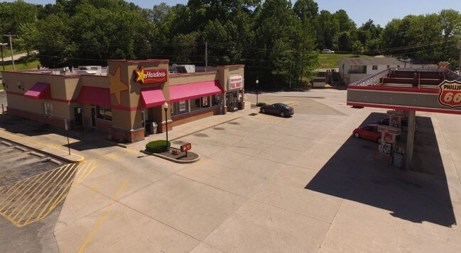
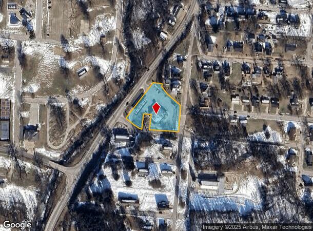
Property Record
115 State Route 19 S, Hermann, MO 65041
NEARBY LISTINGS FOR SALE OR LEASE
Property Detail
115 State Route 19 S
Realpropertynec
PT BLOCKS 1 & 2, W 13TH, PT VAC W 13TH ST, ORIG TOWN HERMANN
AE
Gasconade
29073C0054D
Missouri
2025
1.29 AC
2025
Missouri South Central Area
960100
Other Market Areas
5,895 SF
02-7.0-36-002-029-008.000
DEMOGRAPHICS near 115 State Route 19 S
1 Mile
3 Mile
5 Mile
2024 Total Population
2,459
2,984
3,676
2029 Population
2,483
2,997
3,681
Pop Growth 2024-2029
+ 0.98%
+ 0.44%
+ 0.14%
Average Age
46
46
45
2024 Total Households
1,081
1,308
1,603
HH Growth 2024-2029
+ 0.83%
+ 0.31%
0.00%
Median Household Inc
$60,515
$61,364
$61,041
Avg Household Size
2.20
2.20
2.20
2024 Avg HH Vehicles
2.00
2.00
2.00
Median Home Value
$193,926
$197,634
$205,616
Median Year Built
1969
1969
1970
Nearby Places
Map Layers
Map Styles
 Street
 Aerial
- Restaurants
- Banks
- Shops
- Fitness
- Groceries
PUBLIC TRANSPORTATION
COMMUTER RAIL
Hermann (Lincoln Service Missouri River Runner - Amtrak, Missouri River Runner - Amtrak)
DRIVE
WALK
Distance
Hermann (Lincoln Service Missouri River Runner - Amtrak, Missouri River Runner - Amtrak)
2 min
20 min
1.1 mi
Freight Ports
Tulsa Port of Inola
DRIVE
WALK
Distance
Tulsa Port of Inola
403 min
346.4 mi
SALE & LEASE HISTORY
LISTING DATE
SALE/LEASE

Oct 04, 2016
For Sale
Jun 21, 2019
For Lease
Nearby Properties
Address
Land Use
TOTAL SIZE
Lot Size
Zoning
Address
Land Use
TOTAL SIZE
Lot Size
Zoning
80,000 SF
7.56 AC
Address
Land Use
TOTAL SIZE
Lot Size
Zoning
47,530 SF
23.04 AC
Address
Land Use
TOTAL SIZE
Lot Size
Zoning
11,830 SF
8.84 AC
Address
Land Use
TOTAL SIZE
Lot Size
Zoning
4.27 AC
Address
Land Use
TOTAL SIZE
Lot Size
Zoning
7,020 SF
49.30 AC
Address
Land Use
TOTAL SIZE
Lot Size
Zoning
33,000 SF
3.56 AC
Address
Land Use
TOTAL SIZE
Lot Size
Zoning
6,400 SF
0.50 AC
Address
Land Use
TOTAL SIZE
Lot Size
Zoning
36,445 SF
3.10 AC
Address
Land Use
TOTAL SIZE
Lot Size
Zoning
22,500 SF
3 AC
Address
Land Use
TOTAL SIZE
Lot Size
Zoning
2.72 AC
Address
Land Use
TOTAL SIZE
Lot Size
Zoning
8,346 SF
0.69 AC
Address
Land Use
TOTAL SIZE
Lot Size
Zoning
0.17 AC
Address
Land Use
TOTAL SIZE
Lot Size
Zoning
3,303 SF
0.42 AC
Address
Land Use
TOTAL SIZE
Lot Size
Zoning
20,625 SF
1.32 AC
Address
Land Use
TOTAL SIZE
Lot Size
Zoning
4,620 SF
3.99 AC
Address
Land Use
TOTAL SIZE
Lot Size
Zoning
1,617 SF
14.13 AC
Address
Land Use
TOTAL SIZE
Lot Size
Zoning
57,512 SF
3.46 AC
Address
Land Use
TOTAL SIZE
Lot Size
Zoning
9,588 SF
10.86 AC
Address
Land Use
TOTAL SIZE
Lot Size
Zoning
2.70 AC
Address
Land Use
TOTAL SIZE
Lot Size
Zoning
11,375 SF
3.84 AC
Address
Land Use
TOTAL SIZE
Lot Size
Zoning
0.27 AC
Address
Land Use
TOTAL SIZE
Lot Size
Zoning
4,602 SF
0.21 AC
Address
Land Use
TOTAL SIZE
Lot Size
Zoning
63,360 SF
6.48 AC
Address
Land Use
TOTAL SIZE
Lot Size
Zoning
3,684 SF
0.22 AC
Address
Land Use
TOTAL SIZE
Lot Size
Zoning
1,089 SF
0.50 AC
Address
Land Use
TOTAL SIZE
Lot Size
Zoning
11,700 SF
1.67 AC
Address
Land Use
TOTAL SIZE
Lot Size
Zoning
3,780 SF
0.18 AC
Address
Land Use
TOTAL SIZE
Lot Size
Zoning
1,229 SF
1.65 AC
Address
Land Use
TOTAL SIZE
Lot Size
Zoning
3,952 SF
0.21 AC
The World's #1 Commercial Real Estate Marketplace
Connect with us
© 2025 CoStar Group
The information above has been obtained from sources believed reliable. While we do not doubt its accuracy we have not verified it and make no guarantee, warranty or representation about it. It is your responsibility to independently confirm its accuracy and completeness. Any projections, opinions, assumptions, or estimates used are for example only and do not represent the current or future performance of the property. The value of this transaction to you depends on tax and other factors which should be evaluated by your tax, financial, and legal advisors. You and your advisors should conduct a careful, independent investigation of the property to determine to your satisfaction the suitability of the property for your needs.