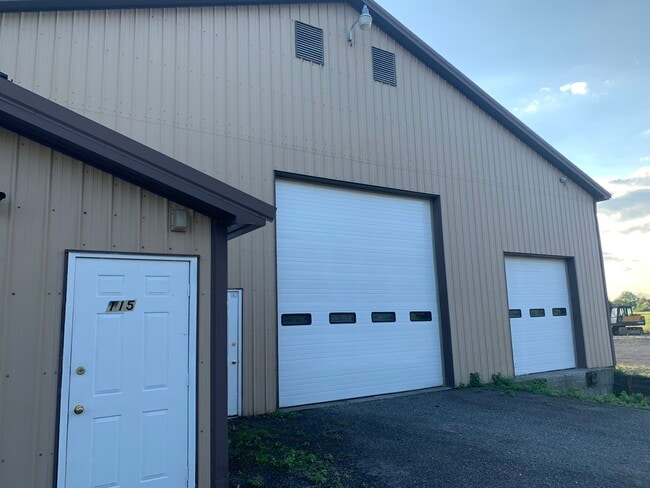
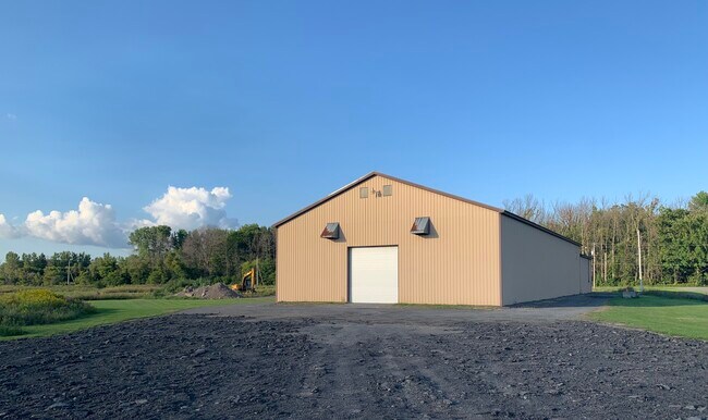
Property Record
115 Warners Rd, Canastota, NY 13032
NEARBY LISTINGS FOR SALE OR LEASE
Property Detail
115 Warners Rd
Syracuse, NY
Madison
253601-028-017-0001-023-000-0000
New York
Truckcrops
11.000
2025
6.61 AC
2024
Madison County
030300
Syracuse
DEMOGRAPHICS near 115 Warners Rd
1 Mile
3 Mile
5 Mile
2024 Total Population
653
7,138
16,293
2029 Population
642
7,002
16,037
Pop Growth 2024-2029
(1.68%)
(1.91%)
(1.57%)
Average Age
43
42
43
2024 Total Households
284
2,966
6,864
HH Growth 2024-2029
(2.11%)
(1.99%)
(1.68%)
Median Household Inc
$51,538
$65,788
$62,514
Avg Household Size
2.20
2.30
2.30
2024 Avg HH Vehicles
2.00
2.00
2.00
Median Home Value
$157,594
$167,042
$164,285
Median Year Built
1966
1961
1961
Nearby Places
- Restaurants
- Banks
- Shops
- Fitness
- Groceries
PUBLIC TRANSPORTATION
AIRPORT
Syracuse Hancock International
DRIVE
WALK
Distance
Syracuse Hancock International
36 min
26.9 mi
Freight Ports
Albany, NY Port
DRIVE
WALK
Distance
Albany, NY Port
146 min
123.2 mi
SALE & LEASE HISTORY
LISTING DATE
SALE/LEASE

Nov 06, 2022
For Lease
Nearby Properties
Address
Land Use
TOTAL SIZE
Lot Size
Zoning
Address
Land Use
TOTAL SIZE
Lot Size
Zoning
198,383 SF
39.78 AC
AG
Address
Land Use
TOTAL SIZE
Lot Size
Zoning
18,912 SF
11.21 AC
Address
Land Use
TOTAL SIZE
Lot Size
Zoning
6.43 AC
IND
Address
Land Use
TOTAL SIZE
Lot Size
Zoning
63,239 SF
17.35 AC
Address
Land Use
TOTAL SIZE
Lot Size
Zoning
480 SF
5.83 AC
IND
Address
Land Use
TOTAL SIZE
Lot Size
Zoning
Address
Land Use
TOTAL SIZE
Lot Size
Zoning
Address
Land Use
TOTAL SIZE
Lot Size
Zoning
Address
Land Use
TOTAL SIZE
Lot Size
Zoning
49,200 SF
7.54 AC
IND
Address
Land Use
TOTAL SIZE
Lot Size
Zoning
24.57 AC
Address
Land Use
TOTAL SIZE
Lot Size
Zoning
75,228 SF
4.27 AC
RM
Address
Land Use
TOTAL SIZE
Lot Size
Zoning
50,196 SF
5.56 AC
Address
Land Use
TOTAL SIZE
Lot Size
Zoning
7,000 SF
32.83 AC
CM
Address
Land Use
TOTAL SIZE
Lot Size
Zoning
105,000 SF
1.52 AC
Address
Land Use
TOTAL SIZE
Lot Size
Zoning
Address
Land Use
TOTAL SIZE
Lot Size
Zoning
24.72 AC
Address
Land Use
TOTAL SIZE
Lot Size
Zoning
1,800 SF
10.97 AC
Address
Land Use
TOTAL SIZE
Lot Size
Zoning
27,850 SF
5.02 AC
AG
Address
Land Use
TOTAL SIZE
Lot Size
Zoning
144,966 SF
8.47 AC
Address
Land Use
TOTAL SIZE
Lot Size
Zoning
17,007 SF
1.21 AC
R2
Address
Land Use
TOTAL SIZE
Lot Size
Zoning
Address
Land Use
TOTAL SIZE
Lot Size
Zoning
19,860 SF
13.11 AC
Address
Land Use
TOTAL SIZE
Lot Size
Zoning
10.08 AC
IND
Address
Land Use
TOTAL SIZE
Lot Size
Zoning
21,928 SF
2.07 AC
PD
Address
Land Use
TOTAL SIZE
Lot Size
Zoning
7,192 SF
4 AC
Address
Land Use
TOTAL SIZE
Lot Size
Zoning
26,848 SF
5.25 AC
AG
Address
Land Use
TOTAL SIZE
Lot Size
Zoning
62,000 SF
10.12 AC
IND
Address
Land Use
TOTAL SIZE
Lot Size
Zoning
17,621 SF
9.97 AC
Address
Land Use
TOTAL SIZE
Lot Size
Zoning
14,673 SF
2.33 AC
CM
Address
Land Use
TOTAL SIZE
Lot Size
Zoning
48,260 SF
10.77 AC
IND
The World's #1 Commercial Real Estate Marketplace
Connect with us
© 2025 CoStar Group
The information above has been obtained from sources believed reliable. While we do not doubt its accuracy we have not verified it and make no guarantee, warranty or representation about it. It is your responsibility to independently confirm its accuracy and completeness. Any projections, opinions, assumptions, or estimates used are for example only and do not represent the current or future performance of the property. The value of this transaction to you depends on tax and other factors which should be evaluated by your tax, financial, and legal advisors. You and your advisors should conduct a careful, independent investigation of the property to determine to your satisfaction the suitability of the property for your needs.