Property Record
115 Wood Rd, Braintree, MA 02184

NEARBY LISTINGS FOR SALE OR LEASE
Property Detail
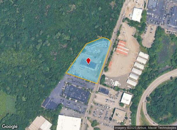
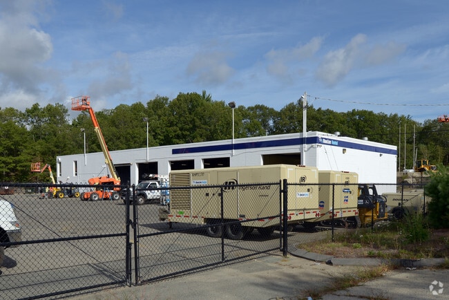
115 Wood Rd
BRAI-002056-000000-000002B
Norfolk
Warehouse
Massachusetts
X
2b
25021C0206F
2.43 AC
2025
Quincy/Braintree
2025
Boston
419100
Boston-Cambridge-Newton, MA-NH
11,160 SF
DEMOGRAPHICS near 115 Wood Rd
1 Mile
3 Mile
5 Mile
2024 Total Population
1,856
95,446
291,386
2029 Population
1,839
94,947
285,454
Pop Growth 2024-2029
(0.92%)
(0.52%)
(2.04%)
Average Age
39
41
41
2024 Total Households
819
38,751
114,080
HH Growth 2024-2029
(0.98%)
(0.43%)
(2.13%)
Median Household Inc
$99,259
$97,921
$93,134
Avg Household Size
2.20
2.40
2.40
2024 Avg HH Vehicles
2.00
2.00
2.00
Median Home Value
$553,030
$638,611
$589,550
Median Year Built
1973
1959
1954
Nearby Places
Map Layers
Map Styles
 Street
 Aerial
- Restaurants
- Banks
- Shops
- Fitness
- Groceries
PUBLIC TRANSPORTATION
COMMUTER RAIL
Braintree (Kingston/Plymouth Line - Massachusetts Bay Transportation Authority Commuter Rail (Purple Line), Middleborough/Lakeville Line - Massachusetts Bay Transportation Authority Commuter Rail (Purple Line))
DRIVE
WALK
Distance
Braintree (Kingston/Plymouth Line - Massachusetts Bay Transportation Authority Commuter Rail (Purple Line), Middleborough/Lakeville Line - Massachusetts Bay Transportation Authority Commuter Rail (Purple Line))
7 min
3.0 mi
Quincy Center Station (Greenbush Line - Massachusetts Bay Transportation Authority Commuter Rail (Purple Line), Kingston/Plymouth Line - Massachusetts Bay Transportation Authority Commuter Rail (Purple Line), Middleborough/Lakeville Line - Massachusetts Bay Transportation Authority Commuter Rail (Purple Line), Red Line - Massachusetts Bay Transportation Authority Commuter Rail (Purple Line))
DRIVE
WALK
Distance
Quincy Center Station (Greenbush Line - Massachusetts Bay Transportation Authority Commuter Rail (Purple Line), Kingston/Plymouth Line - Massachusetts Bay Transportation Authority Commuter Rail (Purple Line), Middleborough/Lakeville Line - Massachusetts Bay Transportation Authority Commuter Rail (Purple Line), Red Line - Massachusetts Bay Transportation Authority Commuter Rail (Purple Line))
9 min
3.4 mi
AIRPORT
General Edward Lawrence Logan International
DRIVE
WALK
Distance
General Edward Lawrence Logan International
23 min
13.3 mi
Freight Ports
Port of Boston
DRIVE
WALK
Distance
Port of Boston
20 min
11.1 mi
Nearby Properties
Address
Land Use
TOTAL SIZE
Lot Size
Zoning
Address
Land Use
TOTAL SIZE
Lot Size
Zoning
148,456 SF
0.43 AC
Address
Land Use
TOTAL SIZE
Lot Size
Zoning
17.33 AC
Address
Land Use
TOTAL SIZE
Lot Size
Zoning
152,495 SF
6.51 AC
Address
Land Use
TOTAL SIZE
Lot Size
Zoning
20,596 SF
16.20 AC
PUD
Address
Land Use
TOTAL SIZE
Lot Size
Zoning
3.31 AC
BUSC
Address
Land Use
TOTAL SIZE
Lot Size
Zoning
236,154 SF
1.41 AC
BUSC
Address
Land Use
TOTAL SIZE
Lot Size
Zoning
14.81 AC
Address
Land Use
TOTAL SIZE
Lot Size
Zoning
15.81 AC
Address
Land Use
TOTAL SIZE
Lot Size
Zoning
9.10 AC
RESC
Address
Land Use
TOTAL SIZE
Lot Size
Zoning
202,858 SF
2.30 AC
Address
Land Use
TOTAL SIZE
Lot Size
Zoning
5.06 AC
BUSC
Address
Land Use
TOTAL SIZE
Lot Size
Zoning
38.48 AC
B
Address
Land Use
TOTAL SIZE
Lot Size
Zoning
132,997 SF
1.45 AC
Address
Land Use
TOTAL SIZE
Lot Size
Zoning
147,611 SF
0.62 AC
BUSC
Address
Land Use
TOTAL SIZE
Lot Size
Zoning
11.90 AC
PUD
Address
Land Use
TOTAL SIZE
Lot Size
Zoning
237,086 SF
15 AC
INDB
Address
Land Use
TOTAL SIZE
Lot Size
Zoning
133,254 SF
4.21 AC
Address
Land Use
TOTAL SIZE
Lot Size
Zoning
124,274 SF
0.62 AC
Address
Land Use
TOTAL SIZE
Lot Size
Zoning
10.38 AC
Address
Land Use
TOTAL SIZE
Lot Size
Zoning
233,530 SF
6.70 AC
PUD
Address
Land Use
TOTAL SIZE
Lot Size
Zoning
134,342 SF
1.03 AC
BUSC
Address
Land Use
TOTAL SIZE
Lot Size
Zoning
5.38 AC
Address
Land Use
TOTAL SIZE
Lot Size
Zoning
16.08 AC
OSC
Address
Land Use
TOTAL SIZE
Lot Size
Zoning
238,217 SF
10.76 AC
INDB
Address
Land Use
TOTAL SIZE
Lot Size
Zoning
10.04 AC
PUD
Address
Land Use
TOTAL SIZE
Lot Size
Zoning
0.25 AC
I
Address
Land Use
TOTAL SIZE
Lot Size
Zoning
130,867 SF
15.29 AC
RA
Address
Land Use
TOTAL SIZE
Lot Size
Zoning
244,796 SF
2.42 AC
Address
Land Use
TOTAL SIZE
Lot Size
Zoning
395,130 SF
6.50 AC
IND
Address
Land Use
TOTAL SIZE
Lot Size
Zoning
272,440 SF
13.16 AC
INDB
The World's #1 Commercial Real Estate Marketplace
Connect with us
© 2025 CoStar Group
The information above has been obtained from sources believed reliable. While we do not doubt its accuracy we have not verified it and make no guarantee, warranty or representation about it. It is your responsibility to independently confirm its accuracy and completeness. Any projections, opinions, assumptions, or estimates used are for example only and do not represent the current or future performance of the property. The value of this transaction to you depends on tax and other factors which should be evaluated by your tax, financial, and legal advisors. You and your advisors should conduct a careful, independent investigation of the property to determine to your satisfaction the suitability of the property for your needs.