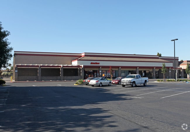
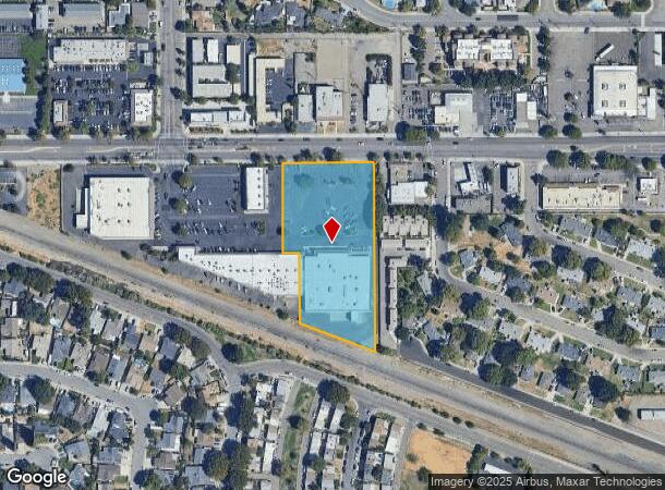
Property Record
1122 W 11Th St, Tracy, CA 95376
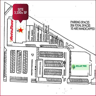
Current Lease Availabilities
NEARBY LISTINGS FOR SALE OR LEASE
Property Detail
1122 W 11Th St
234-050-07
REDRAWN OCT-21-1993 FROM ORIGINAL APN 231-080-11
Regionalshoppingcenterormallwithanchorstore
San Joaquin
X
California
06077C0730F
2.71 AC
2025
Tracy/Manteca
2025
Stockton/Modesto
005403
Stockton-Lodi, CA
29,604 SF
DEMOGRAPHICS near 1122 W 11Th St
1 Mile
3 Mile
5 Mile
2024 Total Population
23,142
96,880
103,789
2029 Population
24,390
102,171
109,712
Pop Growth 2024-2029
+ 5.39%
+ 5.46%
+ 5.71%
Average Age
37
37
37
2024 Total Households
7,309
28,859
30,988
HH Growth 2024-2029
+ 5.40%
+ 5.47%
+ 5.72%
Median Household Inc
$91,974
$109,867
$110,956
Avg Household Size
3.10
3.30
3.30
2024 Avg HH Vehicles
2.00
3.00
3.00
Median Home Value
$506,394
$630,049
$642,604
Median Year Built
1984
1993
1994
Nearby Places
Map Layers
Map Styles
 Street
 Aerial
- Restaurants
- Banks
- Shops
- Fitness
- Groceries
PUBLIC TRANSPORTATION
COMMUTER RAIL
Tracy Station (ACE Train - Altamont Corridor Express)
DRIVE
WALK
Distance
Tracy Station (ACE Train - Altamont Corridor Express)
6 min
3.3 mi
Tracy (Altamont Corridor Express - Altamont Commuter Express (ACE))
DRIVE
WALK
Distance
Tracy (Altamont Corridor Express - Altamont Commuter Express (ACE))
5 min
3.3 mi
AIRPORT
Stockton Metro
DRIVE
WALK
Distance
Stockton Metro
26 min
19.3 mi
Freight Ports
Port of Stockton
DRIVE
WALK
Distance
Port of Stockton
29 min
22.6 mi
Nearby Properties
Address
Land Use
TOTAL SIZE
Lot Size
Zoning
Address
Land Use
TOTAL SIZE
Lot Size
Zoning
3,485,402 SF
86.48 AC
Address
Land Use
TOTAL SIZE
Lot Size
Zoning
610,914 SF
28.11 AC
M1
Address
Land Use
TOTAL SIZE
Lot Size
Zoning
8.90 AC
Address
Land Use
TOTAL SIZE
Lot Size
Zoning
925,475 SF
42.09 AC
Address
Land Use
TOTAL SIZE
Lot Size
Zoning
1,601 SF
17.08 AC
PUD1
Address
Land Use
TOTAL SIZE
Lot Size
Zoning
657,600 SF
44.03 AC
Address
Land Use
TOTAL SIZE
Lot Size
Zoning
3.77 AC
Address
Land Use
TOTAL SIZE
Lot Size
Zoning
1,124,201 SF
53.72 AC
Address
Land Use
TOTAL SIZE
Lot Size
Zoning
795,732 SF
36.67 AC
IG
Address
Land Use
TOTAL SIZE
Lot Size
Zoning
22,926 SF
11.63 AC
Address
Land Use
TOTAL SIZE
Lot Size
Zoning
749,840 SF
37.96 AC
Address
Land Use
TOTAL SIZE
Lot Size
Zoning
10.15 AC
PUD1
Address
Land Use
TOTAL SIZE
Lot Size
Zoning
24.07 AC
Address
Land Use
TOTAL SIZE
Lot Size
Zoning
567,870 SF
36.41 AC
M1
Address
Land Use
TOTAL SIZE
Lot Size
Zoning
461,810 SF
23.23 AC
PUD3
Address
Land Use
TOTAL SIZE
Lot Size
Zoning
29,442 SF
6.52 AC
Address
Land Use
TOTAL SIZE
Lot Size
Zoning
827,280 SF
36.18 AC
Address
Land Use
TOTAL SIZE
Lot Size
Zoning
9,327 SF
12.06 AC
Address
Land Use
TOTAL SIZE
Lot Size
Zoning
381,600 SF
19.46 AC
Address
Land Use
TOTAL SIZE
Lot Size
Zoning
22,726 SF
8.96 AC
PUD1
Address
Land Use
TOTAL SIZE
Lot Size
Zoning
309,108 SF
19.39 AC
Address
Land Use
TOTAL SIZE
Lot Size
Zoning
442,350 SF
27.01 AC
CN
Address
Land Use
TOTAL SIZE
Lot Size
Zoning
143,280 SF
20 AC
Address
Land Use
TOTAL SIZE
Lot Size
Zoning
575,167 SF
46.44 AC
Address
Land Use
TOTAL SIZE
Lot Size
Zoning
382,260 SF
18.70 AC
Address
Land Use
TOTAL SIZE
Lot Size
Zoning
532,500 SF
25.15 AC
Address
Land Use
TOTAL SIZE
Lot Size
Zoning
265,868 SF
11.99 AC
Address
Land Use
TOTAL SIZE
Lot Size
Zoning
265,000 SF
10.83 AC
The World's #1 Commercial Real Estate Marketplace
Connect with us
© 2026 CoStar Group
The information above has been obtained from sources believed reliable. While we do not doubt its accuracy we have not verified it and make no guarantee, warranty or representation about it. It is your responsibility to independently confirm its accuracy and completeness. Any projections, opinions, assumptions, or estimates used are for example only and do not represent the current or future performance of the property. The value of this transaction to you depends on tax and other factors which should be evaluated by your tax, financial, and legal advisors. You and your advisors should conduct a careful, independent investigation of the property to determine to your satisfaction the suitability of the property for your needs.