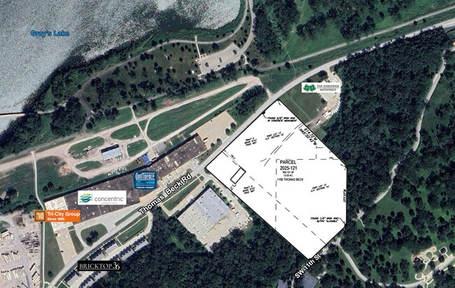
Property Record
1200 Thomas Beck Rd, Des Moines, IA 50315

This Property Is For Sale
NEARBY LISTINGS FOR SALE OR LEASE
-
-
-
Southwest 8th St @ Martin Luther King Jr Pkwy
Des Moines, IA 50309
Rent Upon Request
0.65 AC Lots
Land
-
-
-
-
-
-
-
View all Des Moines listings for sale on LoopNet.com
Property Detail
1200 Thomas Beck Rd
010/06432-001-003
Sec 16-78-24
Warehouse
-EX COM N 1/4 COR SEC 16 THN S 974.09F W 648.44F SW 318.71F TO POB THN SW 102.99F NW 6.5F NE 44.88F NE 58.48F TO POB- SELY OF THOMAS BECK RD & W OF W ROW LN 10TH ST & SW 15.3F SLY ALNG CRV 621.09F SW368.57F TO BEG THN SW 88.56F SLY 62F SE 892.51F NE
X
Polk
19153C0335F
Iowa
2024
3.07 AC
2025
South
004100
Des Moines
4,410 SF
Des Moines-West Des Moines, IA
DEMOGRAPHICS near 1200 Thomas Beck Rd
1 Mile
3 Mile
5 Mile
2024 Total Population
7,753
95,616
200,915
2029 Population
8,152
99,946
209,268
Pop Growth 2024-2029
+ 5.15%
+ 4.53%
+ 4.16%
Average Age
37
37
38
2024 Total Households
3,881
41,608
83,716
HH Growth 2024-2029
+ 5.62%
+ 4.84%
+ 4.40%
Median Household Inc
$61,425
$54,114
$58,093
Avg Household Size
2.00
2.20
2.30
2024 Avg HH Vehicles
2.00
2.00
2.00
Median Home Value
$158,524
$166,617
$162,507
Median Year Built
1961
1967
1959
Nearby Places
Map Layers
Map Styles
 Street
 Aerial
- Restaurants
- Banks
- Shops
- Fitness
- Groceries
PUBLIC TRANSPORTATION
AIRPORT
Des Moines International
DRIVE
WALK
Distance
Des Moines International
9 min
3.7 mi
Freight Ports
Port Milwaukee
DRIVE
WALK
Distance
Port Milwaukee
419 min
375.5 mi
Nearby Properties
Address
Land Use
TOTAL SIZE
Lot Size
Zoning
Address
Land Use
TOTAL SIZE
Lot Size
Zoning
936,742 SF
6.85 AC
C-0
Address
Land Use
TOTAL SIZE
Lot Size
Zoning
2,157,357 SF
23.95 AC
PUD
Address
Land Use
TOTAL SIZE
Lot Size
Zoning
594,010 SF
24.40 AC
R1-80
Address
Land Use
TOTAL SIZE
Lot Size
Zoning
839,211 SF
4.93 AC
C-3A
Address
Land Use
TOTAL SIZE
Lot Size
Zoning
428,582 SF
6.87 AC
C-0
Address
Land Use
TOTAL SIZE
Lot Size
Zoning
260,284 SF
2.98 AC
Address
Land Use
TOTAL SIZE
Lot Size
Zoning
339,258 SF
9.50 AC
R3
Address
Land Use
TOTAL SIZE
Lot Size
Zoning
972,206 SF
1.23 AC
C-3
Address
Land Use
TOTAL SIZE
Lot Size
Zoning
484,524 SF
2.03 AC
C-3
Address
Land Use
TOTAL SIZE
Lot Size
Zoning
289,527 SF
11.23 AC
PUD
Address
Land Use
TOTAL SIZE
Lot Size
Zoning
798,696 SF
4.04 AC
C-3
Address
Land Use
TOTAL SIZE
Lot Size
Zoning
529,814 SF
3.11 AC
C-3
Address
Land Use
TOTAL SIZE
Lot Size
Zoning
274,736 SF
10.27 AC
R-3
Address
Land Use
TOTAL SIZE
Lot Size
Zoning
311,655 SF
2.38 AC
C3
Address
Land Use
TOTAL SIZE
Lot Size
Zoning
162,578 SF
6.37 AC
Address
Land Use
TOTAL SIZE
Lot Size
Zoning
177,094 SF
24.60 AC
Address
Land Use
TOTAL SIZE
Lot Size
Zoning
300,115 SF
2.48 AC
Address
Land Use
TOTAL SIZE
Lot Size
Zoning
208,955 SF
1.84 AC
Address
Land Use
TOTAL SIZE
Lot Size
Zoning
335,556 SF
0.86 AC
C-3
Address
Land Use
TOTAL SIZE
Lot Size
Zoning
461,246 SF
2.11 AC
C-3
Address
Land Use
TOTAL SIZE
Lot Size
Zoning
254,071 SF
9.17 AC
R3
Address
Land Use
TOTAL SIZE
Lot Size
Zoning
262,833 SF
0.97 AC
C-3
Address
Land Use
TOTAL SIZE
Lot Size
Zoning
402,849 SF
0.83 AC
C-3
Address
Land Use
TOTAL SIZE
Lot Size
Zoning
122,364 SF
0.96 AC
C-0
Address
Land Use
TOTAL SIZE
Lot Size
Zoning
179,663 SF
2.27 AC
PUD
Address
Land Use
TOTAL SIZE
Lot Size
Zoning
244,212 SF
2.20 AC
NPC
Address
Land Use
TOTAL SIZE
Lot Size
Zoning
432,630 SF
0.82 AC
C-3
Address
Land Use
TOTAL SIZE
Lot Size
Zoning
342,000 SF
22.18 AC
Address
Land Use
TOTAL SIZE
Lot Size
Zoning
178,611 SF
3.02 AC
The World's #1 Commercial Real Estate Marketplace
Connect with us
© 2026 CoStar Group
The information above has been obtained from sources believed reliable. While we do not doubt its accuracy we have not verified it and make no guarantee, warranty or representation about it. It is your responsibility to independently confirm its accuracy and completeness. Any projections, opinions, assumptions, or estimates used are for example only and do not represent the current or future performance of the property. The value of this transaction to you depends on tax and other factors which should be evaluated by your tax, financial, and legal advisors. You and your advisors should conduct a careful, independent investigation of the property to determine to your satisfaction the suitability of the property for your needs.