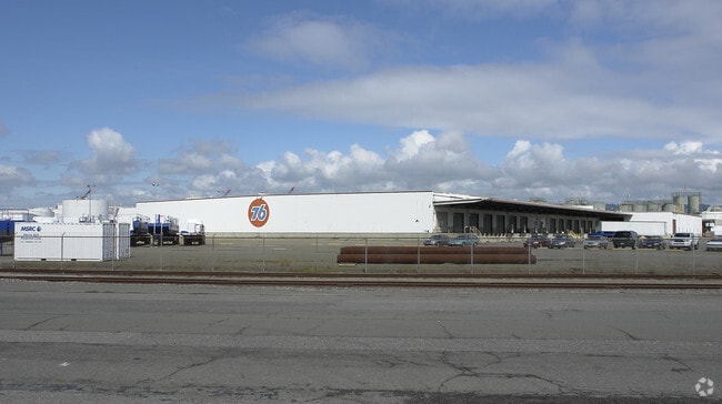
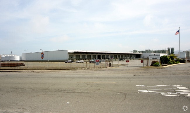
Property Record
1150 Canal Blvd, Richmond, CA 94804

NEARBY LISTINGS FOR SALE OR LEASE
Property Detail
1150 Canal Blvd
Oakland-Hayward-Berkeley, CA
Map #1 Salt Marsh & Tide Lands
560-320-012-1
POR SEC 24 T1N R5W & TR ADJ
Heavyindustrial
Contra Costa
AE
California
06013C0236G
35.94 AC
2024
Richmond/San Pablo
2025
East Bay/Oakland
378000
DEMOGRAPHICS near 1150 Canal Blvd
1 Mile
3 Mile
5 Mile
2024 Total Population
4,749
87,657
196,414
2029 Population
4,723
86,897
194,265
Pop Growth 2024-2029
(0.55%)
(0.87%)
(1.09%)
Average Age
41
37
39
2024 Total Households
1,760
27,664
66,348
HH Growth 2024-2029
(0.51%)
(0.89%)
(1.15%)
Median Household Inc
$103,322
$74,005
$87,782
Avg Household Size
2.60
3.00
2.80
2024 Avg HH Vehicles
2.00
2.00
2.00
Median Home Value
$853,354
$656,319
$781,047
Median Year Built
1972
1959
1958
Nearby Places
Map Layers
Map Styles
 Street
 Aerial
- Restaurants
- Banks
- Shops
- Fitness
- Groceries
PUBLIC TRANSPORTATION
COMMUTER RAIL
DRIVE
WALK
Distance
7 min
3.0 mi
DRIVE
WALK
Distance
14 min
8.6 mi
AIRPORT
Metro Oakland International
DRIVE
WALK
Distance
Metro Oakland International
33 min
23.0 mi
San Francisco International
DRIVE
WALK
Distance
San Francisco International
45 min
30.6 mi
Freight Ports
Port of Richmond
DRIVE
WALK
Distance
Port of Richmond
6 min
2.1 mi
Nearby Properties
Address
Land Use
TOTAL SIZE
Lot Size
Zoning
Address
Land Use
TOTAL SIZE
Lot Size
Zoning
244.30 AC
Address
Land Use
TOTAL SIZE
Lot Size
Zoning
55.76 AC
Address
Land Use
TOTAL SIZE
Lot Size
Zoning
269.14 AC
Address
Land Use
TOTAL SIZE
Lot Size
Zoning
38.33 AC
Address
Land Use
TOTAL SIZE
Lot Size
Zoning
820,000 SF
6.36 AC
Address
Land Use
TOTAL SIZE
Lot Size
Zoning
68,400 SF
5.13 AC
CM
Address
Land Use
TOTAL SIZE
Lot Size
Zoning
76.15 AC
Address
Land Use
TOTAL SIZE
Lot Size
Zoning
476,200 SF
22.92 AC
Address
Land Use
TOTAL SIZE
Lot Size
Zoning
581,157 SF
10.52 AC
Address
Land Use
TOTAL SIZE
Lot Size
Zoning
195,281 SF
0.96 AC
Address
Land Use
TOTAL SIZE
Lot Size
Zoning
139,846 SF
0.76 AC
Address
Land Use
TOTAL SIZE
Lot Size
Zoning
3,950 SF
11.47 AC
Address
Land Use
TOTAL SIZE
Lot Size
Zoning
19,308 SF
40.39 AC
Address
Land Use
TOTAL SIZE
Lot Size
Zoning
105,704 SF
10.85 AC
M3
Address
Land Use
TOTAL SIZE
Lot Size
Zoning
22.06 AC
Address
Land Use
TOTAL SIZE
Lot Size
Zoning
16,800 SF
11.62 AC
Address
Land Use
TOTAL SIZE
Lot Size
Zoning
4,550 SF
24.81 AC
Address
Land Use
TOTAL SIZE
Lot Size
Zoning
245,894 SF
12.67 AC
M2
Address
Land Use
TOTAL SIZE
Lot Size
Zoning
202,811 SF
10.98 AC
Address
Land Use
TOTAL SIZE
Lot Size
Zoning
191,800 SF
1.09 AC
Address
Land Use
TOTAL SIZE
Lot Size
Zoning
124,257 SF
2.72 AC
Address
Land Use
TOTAL SIZE
Lot Size
Zoning
149,502 SF
7.94 AC
Address
Land Use
TOTAL SIZE
Lot Size
Zoning
69,949 SF
0.65 AC
C2 CD
Address
Land Use
TOTAL SIZE
Lot Size
Zoning
182,408 SF
10.55 AC
Address
Land Use
TOTAL SIZE
Lot Size
Zoning
34.95 AC
M3
Address
Land Use
TOTAL SIZE
Lot Size
Zoning
81,352 SF
5.06 AC
C2
Address
Land Use
TOTAL SIZE
Lot Size
Zoning
96,440 SF
4.73 AC
Address
Land Use
TOTAL SIZE
Lot Size
Zoning
404,098 SF
24.03 AC
MSL1RD
Address
Land Use
TOTAL SIZE
Lot Size
Zoning
131,400 SF
8.93 AC
M-1
The World's #1 Commercial Real Estate Marketplace
Connect with us
© 2025 CoStar Group
The information above has been obtained from sources believed reliable. While we do not doubt its accuracy we have not verified it and make no guarantee, warranty or representation about it. It is your responsibility to independently confirm its accuracy and completeness. Any projections, opinions, assumptions, or estimates used are for example only and do not represent the current or future performance of the property. The value of this transaction to you depends on tax and other factors which should be evaluated by your tax, financial, and legal advisors. You and your advisors should conduct a careful, independent investigation of the property to determine to your satisfaction the suitability of the property for your needs.