Property Record
1150 Catamount Dr, Golden, CO 80403


Property Detail
1150 Catamount Dr
30-213-11-001
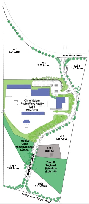
SECTION 21 TOWNSHIP 03 RANGE 70 QTR SW SUBDIVISIONCD 114805 SUBDIVISIONNAME CATAMOUNT SUB FILING 1 BLOCK LOT 0007 SIZE: 116305 TRACT VALUE: 2.670
Industrialgeneral
Jefferson
R1
Colorado
B and X Area of moderate flood hazard, usually the area between the limits of the 100-year and 500-year floods.
7
2025
2.67 AC
2025
West Denver
009858
Denver
26,180 SF
Denver-Aurora-Centennial, CO
NEARBY LISTINGS FOR SALE OR LEASE
-
-
View all Golden listings for sale on LoopNet.com
DEMOGRAPHICS near 1150 Catamount Dr
1 mile
3 mile
5 mile
2025 Total Population
3,736
17,560
50,680
2030 Population
3,767
17,648
50,658
Pop Growth 2025-2030
+ 0.83%
+ 0.50%
(0.04%)
Average Age
43
39
41
2025 Total Households
1,554
6,583
19,775
HH Growth 2025-2030
+ 0.97%
+ 0.74%
(0.04%)
Median Household Inc
$142,091
$116,262
$122,679
Avg Household Size
2.40
2.30
2.40
2025 Avg HH Vehicles
2.00
2.00
2.00
Median Home Value
$1,018,407
$907,068
$831,529
Median Year Built
1992
1987
1990
Nearby Places
Map Layers
Map Styles
 Street
 Aerial
Layers
 Traffic
 Biking
Places
Listings with unknown addresses are not visible on the map
- Restaurants
- Banks
- Shops
- Fitness
- Groceries
PUBLIC TRANSPORTATION
COMMUTER RAIL
Drive
Walk
Distance
15 min
8.3 mi
Drive
Walk
Distance
16 min
9.3 mi
AIRPORT
Denver International
Drive
Walk
Distance
Denver International
49 min
36.9 mi
Nearby Properties
Address
Land Use
TOTAL SIZE
Lot Size
Zoning
Address
Land Use
TOTAL SIZE
Lot Size
Zoning
2,710,724 SF
32.87 AC
Address
Land Use
TOTAL SIZE
Lot Size
Zoning
69,819 SF
1,402.21 AC
R1
Address
Land Use
TOTAL SIZE
Lot Size
Zoning
103,076 SF
1.28 AC
Address
Land Use
TOTAL SIZE
Lot Size
Zoning
966,836 SF
84.74 AC
I2
Address
Land Use
TOTAL SIZE
Lot Size
Zoning
117,036 SF
1.38 AC
Address
Land Use
TOTAL SIZE
Lot Size
Zoning
52,103 SF
2.44 AC
Address
Land Use
TOTAL SIZE
Lot Size
Zoning
135,113 SF
2.58 AC
Address
Land Use
TOTAL SIZE
Lot Size
Zoning
42,684 SF
2.53 AC
Address
Land Use
TOTAL SIZE
Lot Size
Zoning
1,044.03 AC
A2
Address
Land Use
TOTAL SIZE
Lot Size
Zoning
615,195 SF
23.48 AC
Address
Land Use
TOTAL SIZE
Lot Size
Zoning
104,088 SF
1.31 AC
Address
Land Use
TOTAL SIZE
Lot Size
Zoning
162,271 SF
8.20 AC
Address
Land Use
TOTAL SIZE
Lot Size
Zoning
188,554 SF
33.28 AC
Address
Land Use
TOTAL SIZE
Lot Size
Zoning
484,918 SF
58.36 AC
Address
Land Use
TOTAL SIZE
Lot Size
Zoning
39,374 SF
1.20 AC
Address
Land Use
TOTAL SIZE
Lot Size
Zoning
22,232 SF
2.18 AC
Address
Land Use
TOTAL SIZE
Lot Size
Zoning
220,462 SF
73.85 AC
R1
Address
Land Use
TOTAL SIZE
Lot Size
Zoning
390,157 SF
10.02 AC
Address
Land Use
TOTAL SIZE
Lot Size
Zoning
454.79 AC
A2
Address
Land Use
TOTAL SIZE
Lot Size
Zoning
118,634 SF
6 AC
Address
Land Use
TOTAL SIZE
Lot Size
Zoning
219,542 SF
49.12 AC
I2
Address
Land Use
TOTAL SIZE
Lot Size
Zoning
82,432 SF
1.62 AC
Address
Land Use
TOTAL SIZE
Lot Size
Zoning
64,883 SF
4.74 AC
Address
Land Use
TOTAL SIZE
Lot Size
Zoning
173,498 SF
42.86 AC
Address
Land Use
TOTAL SIZE
Lot Size
Zoning
180,193 SF
4.58 AC
Address
Land Use
TOTAL SIZE
Lot Size
Zoning
6,941 SF
1.03 AC
Address
Land Use
TOTAL SIZE
Lot Size
Zoning
143,558 SF
2.93 AC
Address
Land Use
TOTAL SIZE
Lot Size
Zoning
5,956 SF
0.48 AC
Address
Land Use
TOTAL SIZE
Lot Size
Zoning
40.52 AC
Address
Land Use
TOTAL SIZE
Lot Size
Zoning
9,195 SF
0.24 AC
The World's #1 Commercial Real Estate Marketplace
Connect with us
© 2026 CoStar Group
The information above has been obtained from sources believed reliable. While we do not doubt its accuracy we have not verified it and make no guarantee, warranty or representation about it. It is your responsibility to independently confirm its accuracy and completeness. Any projections, opinions, assumptions, or estimates used are for example only and do not represent the current or future performance of the property. The value of this transaction to you depends on tax and other factors which should be evaluated by your tax, financial, and legal advisors. You and your advisors should conduct a careful, independent investigation of the property to determine to your satisfaction the suitability of the property for your needs.