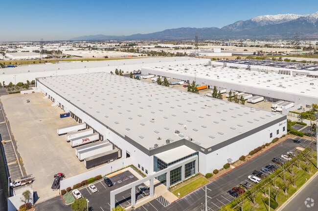
Property Record
1150 Etiwanda Ave, Ontario, CA 91761


NEARBY LISTINGS FOR SALE OR LEASE
-
-
-
-
-
-
-
-
-
-
-
-
-
-
-
-
10513-10567 San Sevaine Way
Jurupa Valley, CA 91752
$3,222,139 - $3,427,861
10,212 - 10,864 SF
Industrial
-
-
-
-
View all Ontario listings for lease on LoopNet.com
Property Detail
1150 Etiwanda Ave
0238-101-68
PARCEL MAP 10729 PARCEL 3 PARCEL MAP 10729 PARCEL 3 AND NLY 6 FT PARCEL 4
Miscellaneous
San Bernardino
X
California
06071C8642J
9.67 AC
2024
Airport Area
2025
Inland Empire (California)
012700
Riverside-San Bernardino-Ontario, CA
234,875 SF
DEMOGRAPHICS near 1150 Etiwanda Ave
1 Mile
3 Mile
5 Mile
2024 Total Population
0
30,028
209,087
2029 Population
0
30,596
213,806
Pop Growth 2024-2029
0.00%
+ 1.89%
+ 2.26%
Average Age
0
37
36
2024 Total Households
0
8,801
60,446
HH Growth 2024-2029
0.00%
+ 2.39%
+ 2.24%
Median Household Inc
$0
$78,457
$91,895
Avg Household Size
.00
3.10
3.30
2024 Avg HH Vehicles
.00
2.00
2.00
Median Home Value
$0
$418,863
$486,210
Median Year Built
0
1985
1989
Nearby Places
Map Layers
Map Styles
 Street
 Aerial
- Restaurants
- Banks
- Shops
- Fitness
- Groceries
PUBLIC TRANSPORTATION
COMMUTER RAIL
East Ontario (Riverside Line - Southern California Regional Rail Authority (Metrolink))
DRIVE
WALK
Distance
East Ontario (Riverside Line - Southern California Regional Rail Authority (Metrolink))
10 min
4.0 mi
Rancho Cucamonga (San Bernardino Line - Southern California Regional Rail Authority (Metrolink))
DRIVE
WALK
Distance
Rancho Cucamonga (San Bernardino Line - Southern California Regional Rail Authority (Metrolink))
11 min
5.0 mi
SALE & LEASE HISTORY
LISTING DATE
SALE/LEASE

Nov 11, 2020
For Lease
Aug 09, 2021
For Lease
Nearby Properties
Address
Land Use
TOTAL SIZE
Lot Size
Zoning
Address
Land Use
TOTAL SIZE
Lot Size
Zoning
1,459,702 SF
96.41 AC
Address
Land Use
TOTAL SIZE
Lot Size
Zoning
1,422,524 SF
44.96 AC
Address
Land Use
TOTAL SIZE
Lot Size
Zoning
362.37 AC
Address
Land Use
TOTAL SIZE
Lot Size
Zoning
1,379,287 SF
62.56 AC
Address
Land Use
TOTAL SIZE
Lot Size
Zoning
1,613,290 SF
59.42 AC
Address
Land Use
TOTAL SIZE
Lot Size
Zoning
707,551 SF
20.36 AC
Address
Land Use
TOTAL SIZE
Lot Size
Zoning
759,260 SF
42.77 AC
Address
Land Use
TOTAL SIZE
Lot Size
Zoning
817,750 SF
35.82 AC
Address
Land Use
TOTAL SIZE
Lot Size
Zoning
760,915 SF
30.34 AC
Address
Land Use
TOTAL SIZE
Lot Size
Zoning
912 SF
370.60 AC
IR
Address
Land Use
TOTAL SIZE
Lot Size
Zoning
752,497 SF
24.89 AC
Address
Land Use
TOTAL SIZE
Lot Size
Zoning
1,385,866 SF
69.84 AC
Address
Land Use
TOTAL SIZE
Lot Size
Zoning
1,286,569 SF
53.96 AC
Address
Land Use
TOTAL SIZE
Lot Size
Zoning
459,431 SF
23.10 AC
Address
Land Use
TOTAL SIZE
Lot Size
Zoning
34.80 AC
Address
Land Use
TOTAL SIZE
Lot Size
Zoning
329,831 SF
15.51 AC
MSC
Address
Land Use
TOTAL SIZE
Lot Size
Zoning
489,989 SF
24.49 AC
Address
Land Use
TOTAL SIZE
Lot Size
Zoning
500,403 SF
24.69 AC
Address
Land Use
TOTAL SIZE
Lot Size
Zoning
453,960 SF
18.54 AC
Address
Land Use
TOTAL SIZE
Lot Size
Zoning
560,025 SF
25.85 AC
Address
Land Use
TOTAL SIZE
Lot Size
Zoning
319,375 SF
14.66 AC
Address
Land Use
TOTAL SIZE
Lot Size
Zoning
210,615 SF
9.42 AC
MM
Address
Land Use
TOTAL SIZE
Lot Size
Zoning
104,537 SF
30.72 AC
Address
Land Use
TOTAL SIZE
Lot Size
Zoning
87,909 SF
30.12 AC
Address
Land Use
TOTAL SIZE
Lot Size
Zoning
286,732 SF
9.58 AC
Address
Land Use
TOTAL SIZE
Lot Size
Zoning
300,205 SF
12.63 AC
Address
Land Use
TOTAL SIZE
Lot Size
Zoning
76.50 AC
Address
Land Use
TOTAL SIZE
Lot Size
Zoning
317,070 SF
14.26 AC
Address
Land Use
TOTAL SIZE
Lot Size
Zoning
19,440 SF
20.95 AC
M2
Address
Land Use
TOTAL SIZE
Lot Size
Zoning
849,900 SF
39.25 AC
KCSP
The World's #1 Commercial Real Estate Marketplace
Connect with us
© 2025 CoStar Group
The information above has been obtained from sources believed reliable. While we do not doubt its accuracy we have not verified it and make no guarantee, warranty or representation about it. It is your responsibility to independently confirm its accuracy and completeness. Any projections, opinions, assumptions, or estimates used are for example only and do not represent the current or future performance of the property. The value of this transaction to you depends on tax and other factors which should be evaluated by your tax, financial, and legal advisors. You and your advisors should conduct a careful, independent investigation of the property to determine to your satisfaction the suitability of the property for your needs.