Property Record
1150 Mcfarland St, Morristown, TN 37814
NEARBY LISTINGS FOR SALE OR LEASE
-
-
View all Morristown listings for sale on LoopNet.com
Property Detail
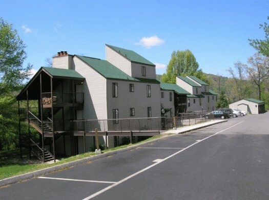
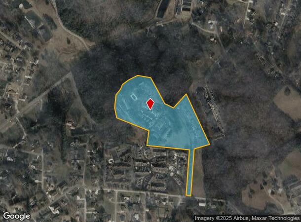
1150 Mcfarland St
Morristown, TN
Hearthstone Condominiums
033F-A-005.00
HEARTHSTONE CONDOMINIUMS PB: A PG: 126 LOT: 4R THE SUMMIT APARTMENT HOMES
Commercialnec
Hamblen
X
Tennessee
47063C0127E
4r
2025
16.25 AC
2025
Tennessee East Area
100400
Other Market Areas
116,498 SF
DEMOGRAPHICS near 1150 Mcfarland St
1 Mile
3 Mile
5 Mile
2024 Total Population
5,573
30,325
46,303
2029 Population
5,698
31,154
47,618
Pop Growth 2024-2029
+ 2.24%
+ 2.73%
+ 2.84%
Average Age
42
39
40
2024 Total Households
2,236
11,849
18,122
HH Growth 2024-2029
+ 2.28%
+ 2.73%
+ 2.83%
Median Household Inc
$47,145
$34,194
$41,935
Avg Household Size
2.30
2.50
2.50
2024 Avg HH Vehicles
2.00
2.00
2.00
Median Home Value
$167,066
$142,850
$156,760
Median Year Built
1977
1973
1977
Nearby Places
Map Layers
Map Styles
 Street
 Aerial
- Restaurants
- Banks
- Shops
- Fitness
- Groceries
Nearby Properties
Address
Land Use
TOTAL SIZE
Lot Size
Zoning
Address
Land Use
TOTAL SIZE
Lot Size
Zoning
195,197 SF
34.43 AC
R2
Address
Land Use
TOTAL SIZE
Lot Size
Zoning
260,722 SF
6.41 AC
R2
Address
Land Use
TOTAL SIZE
Lot Size
Zoning
162,806 SF
30.50 AC
Address
Land Use
TOTAL SIZE
Lot Size
Zoning
146,933 SF
25 AC
Address
Land Use
TOTAL SIZE
Lot Size
Zoning
56,978 SF
13.50 AC
OMP
Address
Land Use
TOTAL SIZE
Lot Size
Zoning
366,006 SF
38.92 AC
Address
Land Use
TOTAL SIZE
Lot Size
Zoning
81,679 SF
30 AC
Address
Land Use
TOTAL SIZE
Lot Size
Zoning
64,435 SF
5.50 AC
Address
Land Use
TOTAL SIZE
Lot Size
Zoning
62,878 SF
25.50 AC
Address
Land Use
TOTAL SIZE
Lot Size
Zoning
58,986 SF
9.75 AC
R2
Address
Land Use
TOTAL SIZE
Lot Size
Zoning
Address
Land Use
TOTAL SIZE
Lot Size
Zoning
52,101 SF
10.58 AC
R2
Address
Land Use
TOTAL SIZE
Lot Size
Zoning
59,466 SF
8.24 AC
OMP
Address
Land Use
TOTAL SIZE
Lot Size
Zoning
75,062 SF
10.89 AC
Address
Land Use
TOTAL SIZE
Lot Size
Zoning
40,008 SF
19.31 AC
Address
Land Use
TOTAL SIZE
Lot Size
Zoning
74,100 SF
10.10 AC
Address
Land Use
TOTAL SIZE
Lot Size
Zoning
143,489 SF
9.37 AC
R3
Address
Land Use
TOTAL SIZE
Lot Size
Zoning
62,820 SF
38.51 AC
IB
Address
Land Use
TOTAL SIZE
Lot Size
Zoning
65,253 SF
9.01 AC
Address
Land Use
TOTAL SIZE
Lot Size
Zoning
25,787 SF
5.04 AC
R2
Address
Land Use
TOTAL SIZE
Lot Size
Zoning
96,448 SF
11.24 AC
Address
Land Use
TOTAL SIZE
Lot Size
Zoning
80,462 SF
11.35 AC
Address
Land Use
TOTAL SIZE
Lot Size
Zoning
134,711 SF
16.31 AC
IB
Address
Land Use
TOTAL SIZE
Lot Size
Zoning
44,916 SF
2.30 AC
Address
Land Use
TOTAL SIZE
Lot Size
Zoning
55,870 SF
Address
Land Use
TOTAL SIZE
Lot Size
Zoning
26,112 SF
1.37 AC
OMP
Address
Land Use
TOTAL SIZE
Lot Size
Zoning
61,853 SF
12.59 AC
OMP
Address
Land Use
TOTAL SIZE
Lot Size
Zoning
20,416 SF
1 AC
R3
Address
Land Use
TOTAL SIZE
Lot Size
Zoning
54,015 SF
2.12 AC
The World's #1 Commercial Real Estate Marketplace
Connect with us
© 2026 CoStar Group
The information above has been obtained from sources believed reliable. While we do not doubt its accuracy we have not verified it and make no guarantee, warranty or representation about it. It is your responsibility to independently confirm its accuracy and completeness. Any projections, opinions, assumptions, or estimates used are for example only and do not represent the current or future performance of the property. The value of this transaction to you depends on tax and other factors which should be evaluated by your tax, financial, and legal advisors. You and your advisors should conduct a careful, independent investigation of the property to determine to your satisfaction the suitability of the property for your needs.