Property Record
1150 Niles Cortland Rd, Niles, OH 44446


Save to a Folder
{{folder.Name}}
{{folder.ListingIds.length}} Properties
{{folder.ListingIds.length}} Property
Create a New Folder
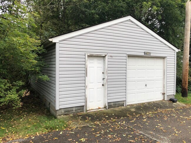
Property Detail
1150 Niles Cortland Rd
Youngstown-Warren, OH
5 172.99 F 1.3463A NCL 8589 PER SURVEY NILES CORTLAND RD NILES CITY
25-219940
Trumbull
Medicalbuilding
Ohio
B and X Area of moderate flood hazard, usually the area between the limits of the 100-year and 500-year floods.
20
2025
1.35 AC
2025
Niles
932701
Youngstown/Warren/Boardman
6,958 SF
NEARBY LISTINGS FOR SALE OR LEASE
DEMOGRAPHICS near 1150 Niles Cortland Rd
1 mile
3 mile
5 mile
2025 Total Population
8,624
35,294
84,161
2030 Population
8,522
35,024
83,925
Pop Growth 2025-2030
(1.18%)
(0.77%)
(0.28%)
Average Age
43
43
43
2025 Total Households
3,937
15,851
36,993
HH Growth 2025-2030
(1.27%)
(0.79%)
(0.36%)
Median Household Inc
$49,256
$50,353
$49,262
Avg Household Size
2.10
2.20
2.20
2025 Avg HH Vehicles
2.00
2.00
2.00
Median Home Value
$135,263
$133,952
$134,135
Median Year Built
1965
1963
1962
Nearby Places
Map Layers
Map Styles
 Street
 Aerial
Layers
 Traffic
 Biking
Places
Listings with unknown addresses are not visible on the map
- Restaurants
- Banks
- Shops
- Fitness
- Groceries
SALE & LEASE HISTORY
LISTING DATE
SALE/LEASE

Sep 25, 2016
For Lease
Oct 04, 2021
For Sale
Jun 19, 2018
For Sale
Feb 16, 2017
For Lease
Feb 16, 2017
For Sale
Dec 21, 2016
For Sale
Nearby Properties
Address
Land Use
TOTAL SIZE
Lot Size
Zoning
Address
Land Use
TOTAL SIZE
Lot Size
Zoning
676,583 SF
74.92 AC
Address
Land Use
TOTAL SIZE
Lot Size
Zoning
274,954 SF
6.75 AC
Address
Land Use
TOTAL SIZE
Lot Size
Zoning
8,642 SF
16.50 AC
Address
Land Use
TOTAL SIZE
Lot Size
Zoning
10.30 AC
Address
Land Use
TOTAL SIZE
Lot Size
Zoning
142,467 SF
4.40 AC
Address
Land Use
TOTAL SIZE
Lot Size
Zoning
77,500 SF
15.96 AC
Address
Land Use
TOTAL SIZE
Lot Size
Zoning
69,132 SF
10 AC
Address
Land Use
TOTAL SIZE
Lot Size
Zoning
159,850 SF
11.29 AC
Address
Land Use
TOTAL SIZE
Lot Size
Zoning
97,754 SF
68.10 AC
Address
Land Use
TOTAL SIZE
Lot Size
Zoning
54,854 SF
9.03 AC
Address
Land Use
TOTAL SIZE
Lot Size
Zoning
145,800 SF
23.19 AC
Address
Land Use
TOTAL SIZE
Lot Size
Zoning
103,556 SF
14.12 AC
Address
Land Use
TOTAL SIZE
Lot Size
Zoning
164,473 SF
14.34 AC
Address
Land Use
TOTAL SIZE
Lot Size
Zoning
6,864 SF
21.03 AC
Address
Land Use
TOTAL SIZE
Lot Size
Zoning
13,464 SF
21.34 AC
Address
Land Use
TOTAL SIZE
Lot Size
Zoning
128,670 SF
7.87 AC
Address
Land Use
TOTAL SIZE
Lot Size
Zoning
17.70 AC
Address
Land Use
TOTAL SIZE
Lot Size
Zoning
1,129 SF
100.32 AC
Address
Land Use
TOTAL SIZE
Lot Size
Zoning
30,850 SF
10.20 AC
Address
Land Use
TOTAL SIZE
Lot Size
Zoning
142,607 SF
4.50 AC
Address
Land Use
TOTAL SIZE
Lot Size
Zoning
62,764 SF
9.16 AC
Address
Land Use
TOTAL SIZE
Lot Size
Zoning
135,221 SF
19.17 AC
Address
Land Use
TOTAL SIZE
Lot Size
Zoning
79,349 SF
2.82 AC
Address
Land Use
TOTAL SIZE
Lot Size
Zoning
134,376 SF
23.39 AC
Address
Land Use
TOTAL SIZE
Lot Size
Zoning
62,994 SF
2.15 AC
Address
Land Use
TOTAL SIZE
Lot Size
Zoning
5,616 SF
23.43 AC
Address
Land Use
TOTAL SIZE
Lot Size
Zoning
111,199 SF
10.92 AC
Address
Land Use
TOTAL SIZE
Lot Size
Zoning
2,080 SF
13.83 AC
Address
Land Use
TOTAL SIZE
Lot Size
Zoning
54,969 SF
6.17 AC
Address
Land Use
TOTAL SIZE
Lot Size
Zoning
22,200 SF
13.80 AC
The World's #1 Commercial Real Estate Marketplace
Connect with us
© 2026 CoStar Group
The information above has been obtained from sources believed reliable. While we do not doubt its accuracy we have not verified it and make no guarantee, warranty or representation about it. It is your responsibility to independently confirm its accuracy and completeness. Any projections, opinions, assumptions, or estimates used are for example only and do not represent the current or future performance of the property. The value of this transaction to you depends on tax and other factors which should be evaluated by your tax, financial, and legal advisors. You and your advisors should conduct a careful, independent investigation of the property to determine to your satisfaction the suitability of the property for your needs.