Property Record
1150 Scenic Hwy, Lawrenceville, GA 30045


Save to a Folder
{{folder.Name}}
{{folder.ListingIds.length}} Properties
{{folder.ListingIds.length}} Property
Create a New Folder
Property Detail
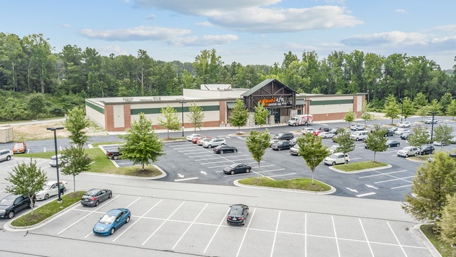
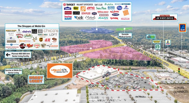
1150 Scenic Hwy
5-087-705
GA HWY 124
Storebuilding
Gwinnett
C2
Georgia
B and X Area of moderate flood hazard, usually the area between the limits of the 100-year and 500-year floods.
3.62 AC
2025
Lawrenceville/Dacula
2025
Atlanta
050580
Atlanta-Sandy Springs-Roswell, GA
52,260 SF
NEARBY LISTINGS FOR SALE OR LEASE
DEMOGRAPHICS near 1150 Scenic Hwy
1 mile
3 mile
5 mile
2025 Total Population
8,063
76,902
210,464
2030 Population
8,449
80,610
220,600
Pop Growth 2025-2030
+ 4.79%
+ 4.82%
+ 4.82%
Average Age
40
39
38
2025 Total Households
2,590
24,754
67,791
HH Growth 2025-2030
+ 4.90%
+ 4.90%
+ 4.93%
Median Household Inc
$114,193
$100,315
$86,524
Avg Household Size
3.10
3.00
3.00
2025 Avg HH Vehicles
2.00
2.00
2.00
Median Home Value
$489,043
$419,777
$379,389
Median Year Built
1997
1995
1995
Nearby Places
Map Layers
Map Styles
 Street
 Aerial
Layers
 Traffic
 Biking
Places
Listings with unknown addresses are not visible on the map
- Restaurants
- Banks
- Shops
- Fitness
- Groceries
SALE & LEASE HISTORY
LISTING DATE
SALE/LEASE

Sep 23, 2016
For Sale
Nov 04, 2019
For Sale
Jan 10, 2017
For Sale
Nearby Properties
Address
Land Use
TOTAL SIZE
Lot Size
Zoning
Address
Land Use
TOTAL SIZE
Lot Size
Zoning
484,262 SF
34.27 AC
RM
Address
Land Use
TOTAL SIZE
Lot Size
Zoning
352,924 SF
86.43 AC
R100
Address
Land Use
TOTAL SIZE
Lot Size
Zoning
362,674 SF
43.59 AC
CI
Address
Land Use
TOTAL SIZE
Lot Size
Zoning
360,279 SF
13.16 AC
RM24
Address
Land Use
TOTAL SIZE
Lot Size
Zoning
333,734 SF
24 AC
BG
Address
Land Use
TOTAL SIZE
Lot Size
Zoning
271,668 SF
20.13 AC
RM13
Address
Land Use
TOTAL SIZE
Lot Size
Zoning
221,082 SF
12.90 AC
RM24
Address
Land Use
TOTAL SIZE
Lot Size
Zoning
201,000 SF
29.98 AC
R75
Address
Land Use
TOTAL SIZE
Lot Size
Zoning
245,208 SF
15.37 AC
RO
Address
Land Use
TOTAL SIZE
Lot Size
Zoning
286,368 SF
34.55 AC
R75
Address
Land Use
TOTAL SIZE
Lot Size
Zoning
274,964 SF
27.82 AC
BG
Address
Land Use
TOTAL SIZE
Lot Size
Zoning
214,399 SF
29.91 AC
C2
Address
Land Use
TOTAL SIZE
Lot Size
Zoning
230,417 SF
24.09 AC
BG
Address
Land Use
TOTAL SIZE
Lot Size
Zoning
309,156 SF
17.39 AC
OI
Address
Land Use
TOTAL SIZE
Lot Size
Zoning
214,082 SF
18.56 AC
BG
Address
Land Use
TOTAL SIZE
Lot Size
Zoning
127,844 SF
7.76 AC
RM8
Address
Land Use
TOTAL SIZE
Lot Size
Zoning
59,949 SF
71.12 AC
C1
Address
Land Use
TOTAL SIZE
Lot Size
Zoning
188,659 SF
5.03 AC
RM13
Address
Land Use
TOTAL SIZE
Lot Size
Zoning
304,682 SF
10.93 AC
RM24
Address
Land Use
TOTAL SIZE
Lot Size
Zoning
132,916 SF
10.23 AC
BG
Address
Land Use
TOTAL SIZE
Lot Size
Zoning
160,939 SF
25.46 AC
R75
Address
Land Use
TOTAL SIZE
Lot Size
Zoning
148,880 SF
23.15 AC
R100
Address
Land Use
TOTAL SIZE
Lot Size
Zoning
145,715 SF
16.90 AC
BG
Address
Land Use
TOTAL SIZE
Lot Size
Zoning
125,097 SF
1.01 AC
CI
Address
Land Use
TOTAL SIZE
Lot Size
Zoning
357,243 SF
59.63 AC
R100
Address
Land Use
TOTAL SIZE
Lot Size
Zoning
118,804 SF
17.66 AC
C2
Address
Land Use
TOTAL SIZE
Lot Size
Zoning
128,054 SF
15.62 AC
BG2
Address
Land Use
TOTAL SIZE
Lot Size
Zoning
105,948 SF
1.24 AC
BG
Address
Land Use
TOTAL SIZE
Lot Size
Zoning
101,193 SF
5.34 AC
C2
Address
Land Use
TOTAL SIZE
Lot Size
Zoning
51,704 SF
17.25 AC
OI
The World's #1 Commercial Real Estate Marketplace
Connect with us
© 2026 CoStar Group
The information above has been obtained from sources believed reliable. While we do not doubt its accuracy we have not verified it and make no guarantee, warranty or representation about it. It is your responsibility to independently confirm its accuracy and completeness. Any projections, opinions, assumptions, or estimates used are for example only and do not represent the current or future performance of the property. The value of this transaction to you depends on tax and other factors which should be evaluated by your tax, financial, and legal advisors. You and your advisors should conduct a careful, independent investigation of the property to determine to your satisfaction the suitability of the property for your needs.