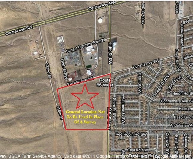
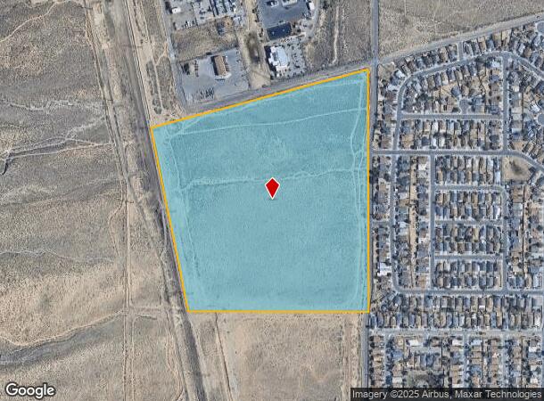
Property Record
11500 Eucariz Ave Sw, Albuquerque, NM 87121
NEARBY LISTINGS FOR SALE OR LEASE
Property Detail
11500 Eucariz Ave Sw
Albuquerque, NM
Westland Atrisco Grant
1-008-056-108092-3-02-03
TRS 21-25 ROW 3 UNIT B OF WESTLAND ATRISCO GRANT & UNPLATTED TRS IN THE S1/2 OF W1/2 IN SW1/4 SW1/4 SEC 29 T10N R2E & PORT OF
Residentialacreage
Bernalillo
A
New Mexico
35001C0317H
51.41 AC
2024
South Valley
2025
Albuquerque
004712
DEMOGRAPHICS near 11500 Eucariz Ave Sw
1 Mile
3 Mile
5 Mile
2024 Total Population
7,757
67,265
130,793
2029 Population
7,618
66,447
129,480
Pop Growth 2024-2029
(1.79%)
(1.22%)
(1.00%)
Average Age
35
34
37
2024 Total Households
2,462
21,032
44,014
HH Growth 2024-2029
(1.99%)
(1.38%)
(1.14%)
Median Household Inc
$58,920
$55,915
$53,252
Avg Household Size
3.00
3.10
2.90
2024 Avg HH Vehicles
2.00
2.00
2.00
Median Home Value
$157,290
$166,109
$178,836
Median Year Built
1993
2001
1993
Nearby Places
Map Layers
Map Styles
 Street
 Aerial
- Restaurants
- Banks
- Shops
- Fitness
- Groceries
PUBLIC TRANSPORTATION
COMMUTER RAIL
Bernalillo County-International Sunport (NMRX - Rio Metro Regional Transit District, Rail Runner Express - Rio Metro Regional Transit District)
DRIVE
WALK
Distance
Bernalillo County-International Sunport (NMRX - Rio Metro Regional Transit District, Rail Runner Express - Rio Metro Regional Transit District)
17 min
8.5 mi
AIRPORT
Albuquerque International Sunport
DRIVE
WALK
Distance
Albuquerque International Sunport
34 min
19.2 mi
Freight Ports
Port of San Diego
DRIVE
WALK
Distance
Port of San Diego
852 min
802.4 mi
Nearby Properties
Address
Land Use
TOTAL SIZE
Lot Size
Zoning
Address
Land Use
TOTAL SIZE
Lot Size
Zoning
2,564,809 SF
72.07 AC
Address
Land Use
TOTAL SIZE
Lot Size
Zoning
Address
Land Use
TOTAL SIZE
Lot Size
Zoning
755,293 SF
49.94 AC
Address
Land Use
TOTAL SIZE
Lot Size
Zoning
46.81 AC
Address
Land Use
TOTAL SIZE
Lot Size
Zoning
3,693 SF
26.56 AC
Address
Land Use
TOTAL SIZE
Lot Size
Zoning
15.17 AC
Address
Land Use
TOTAL SIZE
Lot Size
Zoning
Address
Land Use
TOTAL SIZE
Lot Size
Zoning
196,154 SF
14.81 AC
Address
Land Use
TOTAL SIZE
Lot Size
Zoning
20.08 AC
Address
Land Use
TOTAL SIZE
Lot Size
Zoning
Address
Land Use
TOTAL SIZE
Lot Size
Zoning
256,918 SF
50.96 AC
Address
Land Use
TOTAL SIZE
Lot Size
Zoning
201,339 SF
45.06 AC
Address
Land Use
TOTAL SIZE
Lot Size
Zoning
63,424 SF
9.98 AC
Address
Land Use
TOTAL SIZE
Lot Size
Zoning
151,848 SF
9.69 AC
Address
Land Use
TOTAL SIZE
Lot Size
Zoning
Address
Land Use
TOTAL SIZE
Lot Size
Zoning
122,890 SF
5.42 AC
Address
Land Use
TOTAL SIZE
Lot Size
Zoning
182,708 SF
23.14 AC
Address
Land Use
TOTAL SIZE
Lot Size
Zoning
202,223 SF
10.57 AC
Address
Land Use
TOTAL SIZE
Lot Size
Zoning
202,320 SF
15.12 AC
Address
Land Use
TOTAL SIZE
Lot Size
Zoning
79,080 SF
50.15 AC
Address
Land Use
TOTAL SIZE
Lot Size
Zoning
140,180 SF
3.23 AC
Address
Land Use
TOTAL SIZE
Lot Size
Zoning
130,082 SF
20 AC
Address
Land Use
TOTAL SIZE
Lot Size
Zoning
8,992 SF
16.48 AC
Address
Land Use
TOTAL SIZE
Lot Size
Zoning
91,318 SF
20.96 AC
Address
Land Use
TOTAL SIZE
Lot Size
Zoning
147,805 SF
19.94 AC
Address
Land Use
TOTAL SIZE
Lot Size
Zoning
36,456 SF
9.44 AC
Address
Land Use
TOTAL SIZE
Lot Size
Zoning
Address
Land Use
TOTAL SIZE
Lot Size
Zoning
23,375 SF
14.86 AC
Address
Land Use
TOTAL SIZE
Lot Size
Zoning
4,564 SF
102.91 AC
The World's #1 Commercial Real Estate Marketplace
Connect with us
© 2025 CoStar Group
The information above has been obtained from sources believed reliable. While we do not doubt its accuracy we have not verified it and make no guarantee, warranty or representation about it. It is your responsibility to independently confirm its accuracy and completeness. Any projections, opinions, assumptions, or estimates used are for example only and do not represent the current or future performance of the property. The value of this transaction to you depends on tax and other factors which should be evaluated by your tax, financial, and legal advisors. You and your advisors should conduct a careful, independent investigation of the property to determine to your satisfaction the suitability of the property for your needs.