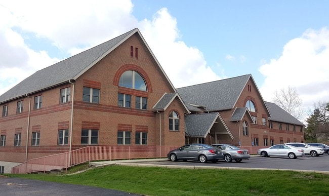
Property Record
1151 Bethel Rd, Columbus, OH 43220

NEARBY LISTINGS FOR SALE OR LEASE
Property Detail
1151 Bethel Rd
010-253251
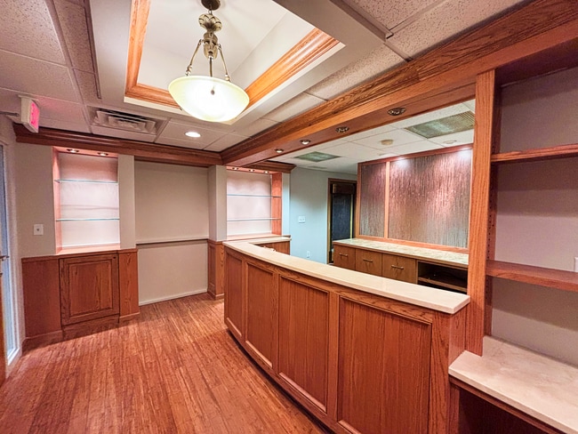
Bethel Grove Office Condominium
Commercialcondominium
BETHEL GROVE OFFICE CONDOMINIUM UNIT 101-B
X
Franklin
39049C0158K
Ohio
2024
0.05 AC
2024
Bethel Rd
030500
Columbus
2,040 SF
Columbus, OH
DEMOGRAPHICS near 1151 Bethel Rd
1 Mile
3 Mile
5 Mile
2024 Total Population
15,495
98,089
312,762
2029 Population
15,481
97,640
311,888
Pop Growth 2024-2029
(0.09%)
(0.46%)
(0.28%)
Average Age
39
41
38
2024 Total Households
7,922
44,865
132,393
HH Growth 2024-2029
+ 0.01%
(0.39%)
(0.28%)
Median Household Inc
$67,076
$83,721
$71,214
Avg Household Size
1.90
2.10
2.20
2024 Avg HH Vehicles
2.00
2.00
2.00
Median Home Value
$274,590
$341,064
$306,197
Median Year Built
1978
1970
1972
Nearby Places
- Restaurants
- Banks
- Shops
- Fitness
- Groceries
PUBLIC TRANSPORTATION
AIRPORT
John Glenn Columbus International
DRIVE
WALK
Distance
John Glenn Columbus International
23 min
15.6 mi
Rickenbacker International
DRIVE
WALK
Distance
Rickenbacker International
34 min
24.0 mi
Freight Ports
Port of Toledo
DRIVE
WALK
Distance
Port of Toledo
175 min
137.7 mi
SALE & LEASE HISTORY
LISTING DATE
SALE/LEASE

Sep 23, 2025
For Lease
Sep 09, 2021
For Sale
May 04, 2018
For Lease
Mar 24, 2025
For Sale
Jun 29, 2023
For Sale
Jun 29, 2023
For Sale
Jun 17, 2021
For Sale
Jan 31, 2022
For Sale
Feb 23, 2017
For Sale
Aug 05, 2017
For Sale
Nearby Properties
Address
Land Use
TOTAL SIZE
Lot Size
Zoning
Address
Land Use
TOTAL SIZE
Lot Size
Zoning
3,462,019 SF
54.42 AC
Address
Land Use
TOTAL SIZE
Lot Size
Zoning
182,845 SF
325.61 AC
Address
Land Use
TOTAL SIZE
Lot Size
Zoning
182,845 SF
325.61 AC
Address
Land Use
TOTAL SIZE
Lot Size
Zoning
240,144 SF
45.78 AC
Address
Land Use
TOTAL SIZE
Lot Size
Zoning
133,425 SF
20.51 AC
Address
Land Use
TOTAL SIZE
Lot Size
Zoning
260,092 SF
29.05 AC
Address
Land Use
TOTAL SIZE
Lot Size
Zoning
344,669 SF
8.45 AC
Address
Land Use
TOTAL SIZE
Lot Size
Zoning
517,875 SF
3.07 AC
Address
Land Use
TOTAL SIZE
Lot Size
Zoning
320,155 SF
84.68 AC
Address
Land Use
TOTAL SIZE
Lot Size
Zoning
234,504 SF
5.40 AC
Address
Land Use
TOTAL SIZE
Lot Size
Zoning
561,921 SF
6.81 AC
Address
Land Use
TOTAL SIZE
Lot Size
Zoning
265,341 SF
19.35 AC
Address
Land Use
TOTAL SIZE
Lot Size
Zoning
286,169 SF
11.08 AC
Address
Land Use
TOTAL SIZE
Lot Size
Zoning
273,578 SF
0.94 AC
Address
Land Use
TOTAL SIZE
Lot Size
Zoning
425,872 SF
10.05 AC
Address
Land Use
TOTAL SIZE
Lot Size
Zoning
160,958 SF
11.93 AC
Address
Land Use
TOTAL SIZE
Lot Size
Zoning
115,032 SF
12.81 AC
Address
Land Use
TOTAL SIZE
Lot Size
Zoning
244,602 SF
27.30 AC
Address
Land Use
TOTAL SIZE
Lot Size
Zoning
254,059 SF
6.94 AC
Address
Land Use
TOTAL SIZE
Lot Size
Zoning
257,993 SF
9.98 AC
Address
Land Use
TOTAL SIZE
Lot Size
Zoning
73,944 SF
11.03 AC
Address
Land Use
TOTAL SIZE
Lot Size
Zoning
115,392 SF
25 AC
Address
Land Use
TOTAL SIZE
Lot Size
Zoning
273,112 SF
13.97 AC
Address
Land Use
TOTAL SIZE
Lot Size
Zoning
162,408 SF
1.73 AC
Address
Land Use
TOTAL SIZE
Lot Size
Zoning
86,934 SF
8.80 AC
Address
Land Use
TOTAL SIZE
Lot Size
Zoning
147,582 SF
5.75 AC
Address
Land Use
TOTAL SIZE
Lot Size
Zoning
170,237 SF
97.38 AC
Address
Land Use
TOTAL SIZE
Lot Size
Zoning
157,919 SF
13.18 AC
Address
Land Use
TOTAL SIZE
Lot Size
Zoning
150,468 SF
24.57 AC
Address
Land Use
TOTAL SIZE
Lot Size
Zoning
138,100 SF
8.38 AC
The World's #1 Commercial Real Estate Marketplace
Connect with us
© 2025 CoStar Group
The information above has been obtained from sources believed reliable. While we do not doubt its accuracy we have not verified it and make no guarantee, warranty or representation about it. It is your responsibility to independently confirm its accuracy and completeness. Any projections, opinions, assumptions, or estimates used are for example only and do not represent the current or future performance of the property. The value of this transaction to you depends on tax and other factors which should be evaluated by your tax, financial, and legal advisors. You and your advisors should conduct a careful, independent investigation of the property to determine to your satisfaction the suitability of the property for your needs.