Property Record
1151 N Ottokee St, Wauseon, OH 43567
NEARBY LISTINGS FOR SALE OR LEASE
-
-
View all Wauseon listings for sale on LoopNet.com
Property Detail
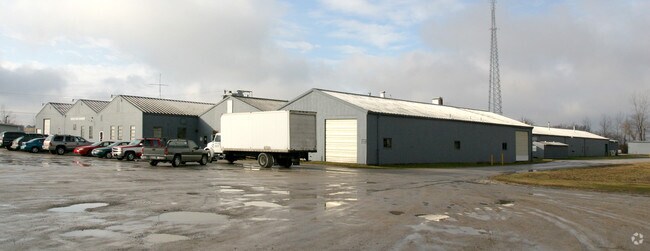
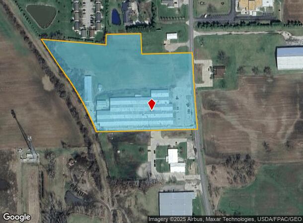
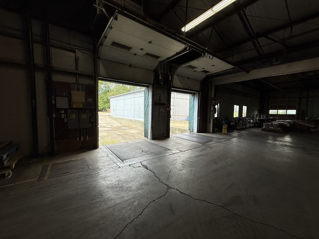
1151 N Ottokee St
06-015584-00.000
6E-7N-14 N PT M PT S3/4 S1/2 SW W OF ROAD EX PAR 8.91A
Commercialnec
Fulton
X
Ohio
39051C0200D
8.91 AC
2024
Fulton County
2024
Toledo
040701
Toledo, OH
61,462 SF
DEMOGRAPHICS near 1151 N Ottokee St
1 Mile
3 Mile
5 Mile
2024 Total Population
3,277
9,712
12,374
2029 Population
3,264
9,678
12,252
Pop Growth 2024-2029
(0.40%)
(0.35%)
(0.99%)
Average Age
38
40
40
2024 Total Households
1,328
3,898
4,908
HH Growth 2024-2029
(0.45%)
(0.36%)
(0.98%)
Median Household Inc
$60,880
$62,425
$64,623
Avg Household Size
2.40
2.40
2.40
2024 Avg HH Vehicles
2.00
2.00
2.00
Median Home Value
$160,988
$167,405
$170,988
Median Year Built
1973
1974
1973
Nearby Places
Map Layers
Map Styles
 Street
 Aerial
- Restaurants
- Banks
- Shops
- Fitness
- Groceries
PUBLIC TRANSPORTATION
AIRPORT
Eugene F Kranz Toledo Express
DRIVE
WALK
Distance
Eugene F Kranz Toledo Express
36 min
19.6 mi
SALE & LEASE HISTORY
LISTING DATE
SALE/LEASE

Oct 23, 2023
For Lease
Nov 11, 2024
For Sale
Feb 20, 2025
For Sale
Feb 20, 2025
For Lease
Nearby Properties
Address
Land Use
TOTAL SIZE
Lot Size
Zoning
Address
Land Use
TOTAL SIZE
Lot Size
Zoning
143,993 SF
8.32 AC
R4
Address
Land Use
TOTAL SIZE
Lot Size
Zoning
137,265 SF
40 AC
R1
Address
Land Use
TOTAL SIZE
Lot Size
Zoning
137,965 SF
43.86 AC
R1
Address
Land Use
TOTAL SIZE
Lot Size
Zoning
170,800 SF
39.11 AC
M2
Address
Land Use
TOTAL SIZE
Lot Size
Zoning
215,270 SF
23.63 AC
B2
Address
Land Use
TOTAL SIZE
Lot Size
Zoning
71,038 SF
20 AC
R2
Address
Land Use
TOTAL SIZE
Lot Size
Zoning
25,036 SF
11.40 AC
Address
Land Use
TOTAL SIZE
Lot Size
Zoning
36,080 SF
17.32 AC
Address
Land Use
TOTAL SIZE
Lot Size
Zoning
26,670 SF
6.50 AC
Address
Land Use
TOTAL SIZE
Lot Size
Zoning
33,180 SF
11.10 AC
Address
Land Use
TOTAL SIZE
Lot Size
Zoning
12,940 SF
3.62 AC
R1
Address
Land Use
TOTAL SIZE
Lot Size
Zoning
99,800 SF
3.30 AC
M2
Address
Land Use
TOTAL SIZE
Lot Size
Zoning
5.47 AC
Address
Land Use
TOTAL SIZE
Lot Size
Zoning
29,950 SF
1.21 AC
B3
Address
Land Use
TOTAL SIZE
Lot Size
Zoning
13,636 SF
1.93 AC
Address
Land Use
TOTAL SIZE
Lot Size
Zoning
30,956 SF
8.48 AC
R4
Address
Land Use
TOTAL SIZE
Lot Size
Zoning
24,168 SF
0.08 AC
Address
Land Use
TOTAL SIZE
Lot Size
Zoning
2,482 SF
11.49 AC
B4
Address
Land Use
TOTAL SIZE
Lot Size
Zoning
13,200 SF
1.67 AC
Address
Land Use
TOTAL SIZE
Lot Size
Zoning
1,632 SF
7.43 AC
R4
Address
Land Use
TOTAL SIZE
Lot Size
Zoning
16,126 SF
2.10 AC
B3
Address
Land Use
TOTAL SIZE
Lot Size
Zoning
58,392 SF
5.96 AC
B2
Address
Land Use
TOTAL SIZE
Lot Size
Zoning
1,404 SF
28.98 AC
Address
Land Use
TOTAL SIZE
Lot Size
Zoning
50.79 AC
Address
Land Use
TOTAL SIZE
Lot Size
Zoning
1,286 SF
219.30 AC
Address
Land Use
TOTAL SIZE
Lot Size
Zoning
5,665 SF
8.18 AC
Address
Land Use
TOTAL SIZE
Lot Size
Zoning
12,000 SF
3.49 AC
M2
Address
Land Use
TOTAL SIZE
Lot Size
Zoning
2,144 SF
230 AC
Address
Land Use
TOTAL SIZE
Lot Size
Zoning
12,874 SF
1.64 AC
B1
Address
Land Use
TOTAL SIZE
Lot Size
Zoning
3,456 SF
5 AC
R4
The World's #1 Commercial Real Estate Marketplace
Connect with us
© 2025 CoStar Group
The information above has been obtained from sources believed reliable. While we do not doubt its accuracy we have not verified it and make no guarantee, warranty or representation about it. It is your responsibility to independently confirm its accuracy and completeness. Any projections, opinions, assumptions, or estimates used are for example only and do not represent the current or future performance of the property. The value of this transaction to you depends on tax and other factors which should be evaluated by your tax, financial, and legal advisors. You and your advisors should conduct a careful, independent investigation of the property to determine to your satisfaction the suitability of the property for your needs.