Property Record
11510 38Th St S, Horace, ND 58047


NEARBY LISTINGS FOR SALE OR LEASE
Property Detail
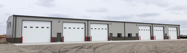
11510 38Th St S
Fargo, ND-MN
Sunny Valley Acres
64-0000-02960-030
LOT: 0 BLOCK: 35 ADDITION: ADDITIONAL: 35-138-49 45.87 AC PT NE1/4 OF NW1/4 WHICH LIES W OF THE INTERSTATE HWY #29 R/W AND THAT PT OF THE S1/2 OF NW1/4 WHICH LIES W OF INT HWY #29 R/W, LESS AUDITOR'S LOTS 1, 2 & 3 OF SD NW1/4 AND LESS COMM AT A PT WH
Realpropertynec
Cass
AE
North Dakota
27167C0025C
1-3
2024
45.87 AC
2024
Fargo
040509
Other Market Areas
DEMOGRAPHICS near 11510 38Th St S
1 Mile
3 Mile
5 Mile
2024 Total Population
43
300
11,928
2029 Population
48
322
13,115
Pop Growth 2024-2029
+ 11.63%
+ 7.33%
+ 9.95%
Average Age
33
37
35
2024 Total Households
18
108
4,212
HH Growth 2024-2029
+ 16.67%
+ 8.33%
+ 10.47%
Median Household Inc
$58,749
$97,726
$119,649
Avg Household Size
2.30
2.70
2.80
2024 Avg HH Vehicles
2.00
3.00
2.00
Median Home Value
$625,000
$383,823
$390,709
Median Year Built
2005
1996
2010
Nearby Places
Map Layers
Map Styles
 Street
 Aerial
- Restaurants
- Banks
- Shops
- Fitness
- Groceries
PUBLIC TRANSPORTATION
AIRPORT
Hector International
DRIVE
WALK
Distance
Hector International
25 min
16.1 mi
Freight Ports
Port Milwaukee
DRIVE
WALK
Distance
Port Milwaukee
639 min
581.5 mi
SALE & LEASE HISTORY
LISTING DATE
SALE/LEASE

Nov 11, 2022
For Lease
Jun 16, 2020
For Lease
Jul 17, 2019
For Lease
Nearby Properties
Address
Land Use
TOTAL SIZE
Lot Size
Zoning
Address
Land Use
TOTAL SIZE
Lot Size
Zoning
223,126 SF
Address
Land Use
TOTAL SIZE
Lot Size
Zoning
53,272 SF
9.34 AC
Address
Land Use
TOTAL SIZE
Lot Size
Zoning
19,840 SF
9.42 AC
Address
Land Use
TOTAL SIZE
Lot Size
Zoning
1.98 AC
Address
Land Use
TOTAL SIZE
Lot Size
Zoning
1.43 AC
Address
Land Use
TOTAL SIZE
Lot Size
Zoning
0.01 AC
Address
Land Use
TOTAL SIZE
Lot Size
Zoning
15,000 SF
32.53 AC
Address
Land Use
TOTAL SIZE
Lot Size
Zoning
1.84 AC
Address
Land Use
TOTAL SIZE
Lot Size
Zoning
21.52 AC
Address
Land Use
TOTAL SIZE
Lot Size
Zoning
21,664 SF
3.24 AC
Address
Land Use
TOTAL SIZE
Lot Size
Zoning
3.25 AC
Address
Land Use
TOTAL SIZE
Lot Size
Zoning
Address
Land Use
TOTAL SIZE
Lot Size
Zoning
14,596 SF
14.73 AC
Address
Land Use
TOTAL SIZE
Lot Size
Zoning
7.52 AC
Address
Land Use
TOTAL SIZE
Lot Size
Zoning
4,694 SF
4.12 AC
Address
Land Use
TOTAL SIZE
Lot Size
Zoning
67.25 AC
Address
Land Use
TOTAL SIZE
Lot Size
Zoning
111.57 AC
Address
Land Use
TOTAL SIZE
Lot Size
Zoning
4,945 SF
19.38 AC
Address
Land Use
TOTAL SIZE
Lot Size
Zoning
3,400 SF
52.21 AC
Address
Land Use
TOTAL SIZE
Lot Size
Zoning
5,278 SF
Address
Land Use
TOTAL SIZE
Lot Size
Zoning
7,180 SF
30.33 AC
Address
Land Use
TOTAL SIZE
Lot Size
Zoning
78.73 AC
Address
Land Use
TOTAL SIZE
Lot Size
Zoning
17,500 SF
2.96 AC
Address
Land Use
TOTAL SIZE
Lot Size
Zoning
78.54 AC
Address
Land Use
TOTAL SIZE
Lot Size
Zoning
7,680 SF
1.08 AC
Address
Land Use
TOTAL SIZE
Lot Size
Zoning
Address
Land Use
TOTAL SIZE
Lot Size
Zoning
37.48 AC
Address
Land Use
TOTAL SIZE
Lot Size
Zoning
4,942 SF
16 AC
Address
Land Use
TOTAL SIZE
Lot Size
Zoning
46.88 AC
The World's #1 Commercial Real Estate Marketplace
Connect with us
© 2025 CoStar Group
The information above has been obtained from sources believed reliable. While we do not doubt its accuracy we have not verified it and make no guarantee, warranty or representation about it. It is your responsibility to independently confirm its accuracy and completeness. Any projections, opinions, assumptions, or estimates used are for example only and do not represent the current or future performance of the property. The value of this transaction to you depends on tax and other factors which should be evaluated by your tax, financial, and legal advisors. You and your advisors should conduct a careful, independent investigation of the property to determine to your satisfaction the suitability of the property for your needs.