Property Record
11511 Canterwood Blvd, Gig Harbor, WA 98332
Current Lease Availabilities
NEARBY LISTINGS FOR SALE OR LEASE
-
-
View all Gig Harbor listings for lease on LoopNet.com
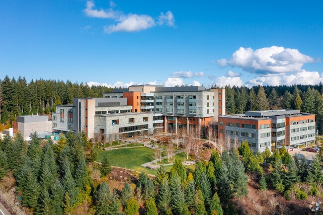
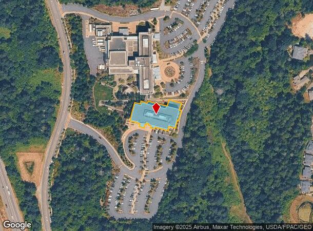
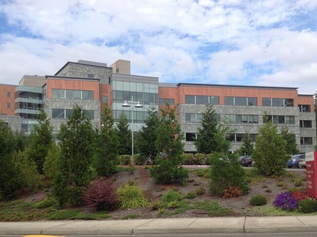
Property Detail
11511 Canterwood Blvd
Seattle-Tacoma-Bellevue, WA
St Anthony Hospital Bsp (A)
300114-0030
SECTION 25 TOWNSHIP 22 RANGE 01 QUARTER 44 BINDING SITE PLAN ST ANTHONY HOSPITAL BSP (A) LOT 3 EASE OF RECORD OUT OF 01-22-25-4-083 SEG 2008-0966 JU 5/20/08JU
Medicalbuilding
Pierce
X
Washington
53033C1200G
3
2024
0.69 AC
2025
Gig Harbor/W Pierce Co
072509
Seattle/Puget Sound
92,797 SF
DEMOGRAPHICS near 11511 Canterwood Blvd
1 Mile
3 Mile
5 Mile
2024 Total Population
6,165
25,900
49,791
2029 Population
6,418
26,796
51,268
Pop Growth 2024-2029
+ 4.10%
+ 3.46%
+ 2.97%
Average Age
42
44
44
2024 Total Households
2,165
9,790
19,089
HH Growth 2024-2029
+ 4.25%
+ 3.52%
+ 3.03%
Median Household Inc
$133,412
$121,602
$118,735
Avg Household Size
2.60
2.50
2.50
2024 Avg HH Vehicles
2.00
2.00
2.00
Median Home Value
$767,263
$714,233
$696,653
Median Year Built
2003
1993
1991
Nearby Places
Map Layers
Map Styles
 Street
 Aerial
- Restaurants
- Banks
- Shops
- Fitness
- Groceries
PUBLIC TRANSPORTATION
AIRPORT
Seattle-Tacoma International
DRIVE
WALK
Distance
Seattle-Tacoma International
52 min
35.7 mi
Freight Ports
Port of Tacoma
DRIVE
WALK
Distance
Port of Tacoma
25 min
17.3 mi
Nearby Properties
Address
Land Use
TOTAL SIZE
Lot Size
Zoning
Address
Land Use
TOTAL SIZE
Lot Size
Zoning
308,000 SF
23.44 AC
PCD-BP
Address
Land Use
TOTAL SIZE
Lot Size
Zoning
427,880 SF
17.97 AC
GIGH
Address
Land Use
TOTAL SIZE
Lot Size
Zoning
318,450 SF
36.63 AC
ED
Address
Land Use
TOTAL SIZE
Lot Size
Zoning
192,969 SF
11.52 AC
PRD
Address
Land Use
TOTAL SIZE
Lot Size
Zoning
321,717 SF
75.30 AC
PI
Address
Land Use
TOTAL SIZE
Lot Size
Zoning
297,754 SF
59.70 AC
PI
Address
Land Use
TOTAL SIZE
Lot Size
Zoning
115,222 SF
27.53 AC
Address
Land Use
TOTAL SIZE
Lot Size
Zoning
87,475 SF
11 AC
Address
Land Use
TOTAL SIZE
Lot Size
Zoning
71,494 SF
14.14 AC
Address
Land Use
TOTAL SIZE
Lot Size
Zoning
117,424 SF
24.84 AC
R-1
Address
Land Use
TOTAL SIZE
Lot Size
Zoning
151,391 SF
17.49 AC
PCD-C
Address
Land Use
TOTAL SIZE
Lot Size
Zoning
295,242 SF
62 AC
PI
Address
Land Use
TOTAL SIZE
Lot Size
Zoning
122,520 SF
10.76 AC
PCD-C
Address
Land Use
TOTAL SIZE
Lot Size
Zoning
77,906 SF
5 AC
R-1
Address
Land Use
TOTAL SIZE
Lot Size
Zoning
122,080 SF
16 AC
PCD-C
Address
Land Use
TOTAL SIZE
Lot Size
Zoning
76,925 SF
11.63 AC
PI
Address
Land Use
TOTAL SIZE
Lot Size
Zoning
2,312 SF
10.39 AC
RB-2
Address
Land Use
TOTAL SIZE
Lot Size
Zoning
55,066 SF
3.49 AC
R-3
Address
Land Use
TOTAL SIZE
Lot Size
Zoning
32,400 SF
1.12 AC
WC
Address
Land Use
TOTAL SIZE
Lot Size
Zoning
57,560 SF
5.43 AC
PCD-C
Address
Land Use
TOTAL SIZE
Lot Size
Zoning
78,180 SF
3.74 AC
ED
Address
Land Use
TOTAL SIZE
Lot Size
Zoning
5,000 SF
18.46 AC
R-2
Address
Land Use
TOTAL SIZE
Lot Size
Zoning
29,470 SF
3.46 AC
PCD-C
Address
Land Use
TOTAL SIZE
Lot Size
Zoning
56,504 SF
12.44 AC
Address
Land Use
TOTAL SIZE
Lot Size
Zoning
18.56 AC
PCD-BP
Address
Land Use
TOTAL SIZE
Lot Size
Zoning
78,478 SF
2.18 AC
ED
Address
Land Use
TOTAL SIZE
Lot Size
Zoning
14,039 SF
162.18 AC
MPC
Address
Land Use
TOTAL SIZE
Lot Size
Zoning
24,460 SF
19.80 AC
SF
Address
Land Use
TOTAL SIZE
Lot Size
Zoning
32,487 SF
2.70 AC
PCD-C
The World's #1 Commercial Real Estate Marketplace
Connect with us
© 2025 CoStar Group
The information above has been obtained from sources believed reliable. While we do not doubt its accuracy we have not verified it and make no guarantee, warranty or representation about it. It is your responsibility to independently confirm its accuracy and completeness. Any projections, opinions, assumptions, or estimates used are for example only and do not represent the current or future performance of the property. The value of this transaction to you depends on tax and other factors which should be evaluated by your tax, financial, and legal advisors. You and your advisors should conduct a careful, independent investigation of the property to determine to your satisfaction the suitability of the property for your needs.