Property Record
11511 Springfield Rd, North Lima, OH 44452
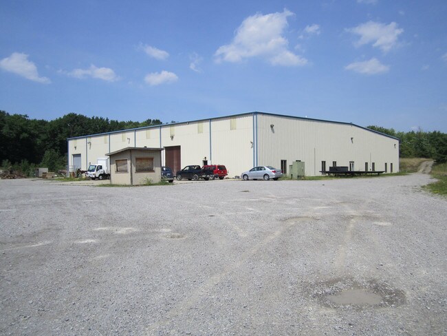

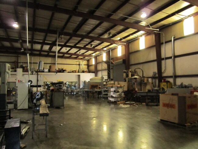
Property Detail
11511 Springfield Rd
Youngstown-Warren, OH
SEC 17
01-173-0-006.00-0
Mahoning
Warehouse
Ohio
2025
64.69 AC
2025
Mahoning County
813601
Youngstown/Warren/Boardman
25,500 SF
NEARBY LISTINGS FOR SALE OR LEASE
-
-
View all North Lima listings for lease on LoopNet.com
DEMOGRAPHICS near 11511 Springfield Rd
1 mile
3 mile
5 mile
2025 Total Population
446
7,486
28,503
2030 Population
435
7,406
28,262
Pop Growth 2025-2030
(2.47%)
(1.07%)
(0.85%)
Average Age
47
47
46
2025 Total Households
187
3,264
12,135
HH Growth 2025-2030
(2.14%)
(1.04%)
(0.83%)
Median Household Inc
$62,452
$61,809
$75,433
Avg Household Size
2.30
2.30
2.30
2025 Avg HH Vehicles
3.00
2.00
2.00
Median Home Value
$209,259
$241,077
$236,107
Median Year Built
1974
1977
1977
Nearby Places
Map Layers
Map Styles
 Street
 Aerial
Layers
 Traffic
 Biking
Places
Listings with unknown addresses are not visible on the map
- Restaurants
- Banks
- Shops
- Fitness
- Groceries
SALE & LEASE HISTORY
LISTING DATE
SALE/LEASE

Sep 06, 2017
For Lease
Nearby Properties
Address
Land Use
TOTAL SIZE
Lot Size
Zoning
Address
Land Use
TOTAL SIZE
Lot Size
Zoning
29,073 SF
7.77 AC
Address
Land Use
TOTAL SIZE
Lot Size
Zoning
105,326 SF
6.75 AC
Address
Land Use
TOTAL SIZE
Lot Size
Zoning
49,014 SF
8.63 AC
C
Address
Land Use
TOTAL SIZE
Lot Size
Zoning
73,489 SF
14.40 AC
Address
Land Use
TOTAL SIZE
Lot Size
Zoning
178,486 SF
18.79 AC
GI
Address
Land Use
TOTAL SIZE
Lot Size
Zoning
50,336 SF
10.09 AC
Address
Land Use
TOTAL SIZE
Lot Size
Zoning
18,736 SF
15.29 AC
GI
Address
Land Use
TOTAL SIZE
Lot Size
Zoning
43,445 SF
3.82 AC
E
Address
Land Use
TOTAL SIZE
Lot Size
Zoning
22,584 SF
9.71 AC
Address
Land Use
TOTAL SIZE
Lot Size
Zoning
19,688 SF
98.45 AC
SR
Address
Land Use
TOTAL SIZE
Lot Size
Zoning
17,477 SF
4.74 AC
GC
Address
Land Use
TOTAL SIZE
Lot Size
Zoning
16,521 SF
3.90 AC
OI
Address
Land Use
TOTAL SIZE
Lot Size
Zoning
29,392 SF
1.89 AC
GC
Address
Land Use
TOTAL SIZE
Lot Size
Zoning
8,530 SF
8.42 AC
Address
Land Use
TOTAL SIZE
Lot Size
Zoning
30,400 SF
23.61 AC
GI
Address
Land Use
TOTAL SIZE
Lot Size
Zoning
32,418 SF
14.36 AC
OI
Address
Land Use
TOTAL SIZE
Lot Size
Zoning
27,125 SF
8.60 AC
Address
Land Use
TOTAL SIZE
Lot Size
Zoning
48,000 SF
19.02 AC
GI
Address
Land Use
TOTAL SIZE
Lot Size
Zoning
15,383 SF
0.60 AC
Address
Land Use
TOTAL SIZE
Lot Size
Zoning
14,631 SF
90.71 AC
A
Address
Land Use
TOTAL SIZE
Lot Size
Zoning
5,074 SF
88.09 AC
GC
Address
Land Use
TOTAL SIZE
Lot Size
Zoning
36.89 AC
GC
Address
Land Use
TOTAL SIZE
Lot Size
Zoning
5,418 SF
10.46 AC
SR
Address
Land Use
TOTAL SIZE
Lot Size
Zoning
3,341 SF
1.40 AC
GC
Address
Land Use
TOTAL SIZE
Lot Size
Zoning
28,550 SF
8.64 AC
GI
Address
Land Use
TOTAL SIZE
Lot Size
Zoning
30,888 SF
27.53 AC
OI
Address
Land Use
TOTAL SIZE
Lot Size
Zoning
12,976 SF
1.43 AC
C
Address
Land Use
TOTAL SIZE
Lot Size
Zoning
4,608 SF
5.62 AC
GI
Address
Land Use
TOTAL SIZE
Lot Size
Zoning
12,500 SF
2 AC
Address
Land Use
TOTAL SIZE
Lot Size
Zoning
16,566 SF
1.47 AC
The World's #1 Commercial Real Estate Marketplace
Connect with us
© 2026 CoStar Group
The information above has been obtained from sources believed reliable. While we do not doubt its accuracy we have not verified it and make no guarantee, warranty or representation about it. It is your responsibility to independently confirm its accuracy and completeness. Any projections, opinions, assumptions, or estimates used are for example only and do not represent the current or future performance of the property. The value of this transaction to you depends on tax and other factors which should be evaluated by your tax, financial, and legal advisors. You and your advisors should conduct a careful, independent investigation of the property to determine to your satisfaction the suitability of the property for your needs.