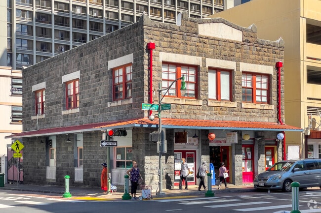
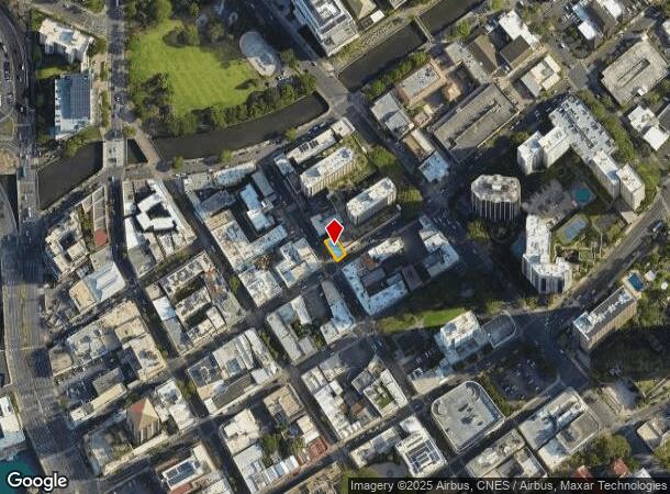
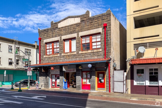
Property Record
1152 Maunakea St, Honolulu, HI 96817
NEARBY LISTINGS FOR SALE OR LEASE
Property Detail
1152 Maunakea St
1-1-7-004-028-0000
PARCEL D-A-7 POR R P 5597 LCAW 70 AP TO WAIAHA 2,527 SF DES
Commercialnec
Honolulu
X
Hawaii
15003C0354G
0.06 AC
2024
CBD
2025
Hawaii
005200
Urban Honolulu, HI
6,300 SF
DEMOGRAPHICS near 1152 Maunakea St
1 Mile
3 Mile
5 Mile
2024 Total Population
51,454
223,151
355,992
2029 Population
50,832
220,228
351,276
Pop Growth 2024-2029
(1.21%)
(1.31%)
(1.32%)
Average Age
44
44
43
2024 Total Households
22,222
91,549
141,639
HH Growth 2024-2029
(1.41%)
(1.19%)
(1.25%)
Median Household Inc
$61,633
$70,916
$74,595
Avg Household Size
2.10
2.30
2.30
2024 Avg HH Vehicles
1.00
1.00
1.00
Median Home Value
$640,278
$714,784
$758,064
Median Year Built
1979
1974
1973
Nearby Places
Map Layers
Map Styles
 Street
 Aerial
- Restaurants
- Banks
- Shops
- Fitness
- Groceries
PUBLIC TRANSPORTATION
AIRPORT
Daniel K Inouye International
DRIVE
WALK
Distance
Daniel K Inouye International
11 min
5.7 mi
Freight Ports
Honolulu Harbor, Oahu
DRIVE
WALK
Distance
Honolulu Harbor, Oahu
12 min
4.7 mi
SALE & LEASE HISTORY
LISTING DATE
SALE/LEASE

May 24, 2024
For Sale
Nearby Properties
Address
Land Use
TOTAL SIZE
Lot Size
Zoning
Address
Land Use
TOTAL SIZE
Lot Size
Zoning
7,944,732 SF
34.93 AC
BMX-3
Address
Land Use
TOTAL SIZE
Lot Size
Zoning
119.90 AC
U/X7/60
Address
Land Use
TOTAL SIZE
Lot Size
Zoning
492,607 SF
9.06 AC
ResMix
Address
Land Use
TOTAL SIZE
Lot Size
Zoning
1,675.63 AC
C/61/60
Address
Land Use
TOTAL SIZE
Lot Size
Zoning
13,088 SF
75.21 AC
P-2
Address
Land Use
TOTAL SIZE
Lot Size
Zoning
1,100,000 SF
9.65 AC
BMX-3
Address
Land Use
TOTAL SIZE
Lot Size
Zoning
55.93 AC
WI
Address
Land Use
TOTAL SIZE
Lot Size
Zoning
1,153,381 SF
425.42 AC
R-5
Address
Land Use
TOTAL SIZE
Lot Size
Zoning
45.65 AC
Kak
Address
Land Use
TOTAL SIZE
Lot Size
Zoning
42.67 AC
P-2
Address
Land Use
TOTAL SIZE
Lot Size
Zoning
1,599,500 SF
7.27 AC
BMX-3
Address
Land Use
TOTAL SIZE
Lot Size
Zoning
2.32 AC
Kak
Address
Land Use
TOTAL SIZE
Lot Size
Zoning
254,832 SF
2.92 AC
BMX-4
Address
Land Use
TOTAL SIZE
Lot Size
Zoning
64,300 SF
0.77 AC
ResMix
Address
Land Use
TOTAL SIZE
Lot Size
Zoning
104,386 SF
1.04 AC
ResMix
Address
Land Use
TOTAL SIZE
Lot Size
Zoning
172,305 SF
2.54 AC
ResMix
Address
Land Use
TOTAL SIZE
Lot Size
Zoning
12,430 SF
86.69 AC
P-1
Address
Land Use
TOTAL SIZE
Lot Size
Zoning
9,272 SF
141.38 AC
P-2
Address
Land Use
TOTAL SIZE
Lot Size
Zoning
1,618,933 SF
1.77 AC
ResMix
Address
Land Use
TOTAL SIZE
Lot Size
Zoning
142,306 SF
3.02 AC
ResMix
Address
Land Use
TOTAL SIZE
Lot Size
Zoning
273,214 SF
1.64 AC
ResMix
Address
Land Use
TOTAL SIZE
Lot Size
Zoning
446,464 SF
9.90 AC
Kak
Address
Land Use
TOTAL SIZE
Lot Size
Zoning
919,972 SF
14.45 AC
I-2
Address
Land Use
TOTAL SIZE
Lot Size
Zoning
22.36 AC
Pub
Address
Land Use
TOTAL SIZE
Lot Size
Zoning
66,180 SF
1.61 AC
ResMix
Address
Land Use
TOTAL SIZE
Lot Size
Zoning
14.38 AC
Kak
Address
Land Use
TOTAL SIZE
Lot Size
Zoning
936,400 SF
6.88 AC
Kak
Address
Land Use
TOTAL SIZE
Lot Size
Zoning
2.88 AC
ResMix
Address
Land Use
TOTAL SIZE
Lot Size
Zoning
386,846 SF
8.76 AC
A-1
Address
Land Use
TOTAL SIZE
Lot Size
Zoning
960 SF
71.97 AC
P-2
The World's #1 Commercial Real Estate Marketplace
Connect with us
© 2025 CoStar Group
The information above has been obtained from sources believed reliable. While we do not doubt its accuracy we have not verified it and make no guarantee, warranty or representation about it. It is your responsibility to independently confirm its accuracy and completeness. Any projections, opinions, assumptions, or estimates used are for example only and do not represent the current or future performance of the property. The value of this transaction to you depends on tax and other factors which should be evaluated by your tax, financial, and legal advisors. You and your advisors should conduct a careful, independent investigation of the property to determine to your satisfaction the suitability of the property for your needs.