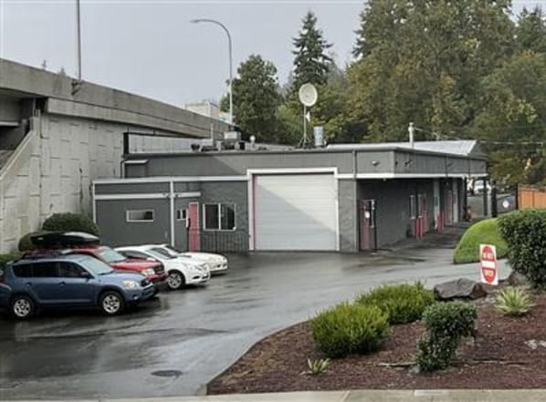
Property Record
11520 Northup Way, Bellevue, WA 98004

NEARBY LISTINGS FOR SALE OR LEASE
Property Detail
11520 Northup Way
Seattle-Tacoma-Bellevue, WA
Kirkland Syndicates 2Nd-Kirkland
389950-0320
KIRKLAND SYNDICATE 2ND-KIRKLAND LESS NP R/W & ALL OF VAC NE 26TH ST N OF BLKS 8-9 SD ADD LESS NP R/W LESS ST HWY ALSO VAC POR 115TH NE ADJ
Commercialnec
King
X
Washington
53033C0368G
2-10
2025
0.53 AC
2024
520 Corridor
023701
Seattle/Puget Sound
3,620 SF
DEMOGRAPHICS near 11520 Northup Way
1 Mile
3 Mile
5 Mile
2024 Total Population
10,067
116,954
267,752
2029 Population
10,136
119,379
271,681
Pop Growth 2024-2029
+ 0.69%
+ 2.07%
+ 1.47%
Average Age
38
39
39
2024 Total Households
4,155
51,543
111,982
HH Growth 2024-2029
+ 0.55%
+ 2.17%
+ 1.54%
Median Household Inc
$171,444
$150,984
$153,064
Avg Household Size
2.30
2.20
2.30
2024 Avg HH Vehicles
2.00
1.00
2.00
Median Home Value
$1,116,334
$1,081,190
$1,062,018
Median Year Built
1983
1989
1984
Nearby Places
Map Layers
Map Styles
 Street
 Aerial
- Restaurants
- Banks
- Shops
- Fitness
- Groceries
PUBLIC TRANSPORTATION
AIRPORT
Seattle Paine Field International
DRIVE
WALK
Distance
Seattle Paine Field International
31 min
21.7 mi
Seattle-Tacoma International
DRIVE
WALK
Distance
Seattle-Tacoma International
34 min
23.3 mi
SALE & LEASE HISTORY
LISTING DATE
SALE/LEASE

Apr 18, 2025
For Lease
Apr 06, 2020
For Lease
Nearby Properties
Address
Land Use
TOTAL SIZE
Lot Size
Zoning
Address
Land Use
TOTAL SIZE
Lot Size
Zoning
223,745 SF
98.45 AC
OBAT
Address
Land Use
TOTAL SIZE
Lot Size
Zoning
6,575 SF
2.03 AC
DNTNO-1
Address
Land Use
TOTAL SIZE
Lot Size
Zoning
629,600 SF
2.62 AC
DNTN-MU
Address
Land Use
TOTAL SIZE
Lot Size
Zoning
482,658 SF
5.78 AC
BR-CR
Address
Land Use
TOTAL SIZE
Lot Size
Zoning
300,118 SF
29.12 AC
OBAT
Address
Land Use
TOTAL SIZE
Lot Size
Zoning
218,371 SF
16.41 AC
DNTN-MU
Address
Land Use
TOTAL SIZE
Lot Size
Zoning
521,058 SF
2.46 AC
DT-O-2-S
Address
Land Use
TOTAL SIZE
Lot Size
Zoning
5,500 SF
1.77 AC
DT-O-2-N
Address
Land Use
TOTAL SIZE
Lot Size
Zoning
397,428 SF
2.48 AC
DT-O-2-N
Address
Land Use
TOTAL SIZE
Lot Size
Zoning
786,424 SF
1.54 AC
DT-O-2-N
Address
Land Use
TOTAL SIZE
Lot Size
Zoning
574,970 SF
1.72 AC
DNTNO-1
Address
Land Use
TOTAL SIZE
Lot Size
Zoning
215,279 SF
14.92 AC
OBAT
Address
Land Use
TOTAL SIZE
Lot Size
Zoning
781,977 SF
1.32 AC
DT-O-2-S
Address
Land Use
TOTAL SIZE
Lot Size
Zoning
723,028 SF
1.73 AC
DNTNO-1
Address
Land Use
TOTAL SIZE
Lot Size
Zoning
331,098 SF
1.50 AC
DNTN-MU
Address
Land Use
TOTAL SIZE
Lot Size
Zoning
538,017 SF
0.91 AC
DNTNO-1
Address
Land Use
TOTAL SIZE
Lot Size
Zoning
105,056 SF
15.92 AC
PLA 15A
Address
Land Use
TOTAL SIZE
Lot Size
Zoning
372,228 SF
1.04 AC
DT-O-2-S
Address
Land Use
TOTAL SIZE
Lot Size
Zoning
134,200 SF
4.04 AC
DT-OLB-N
Address
Land Use
TOTAL SIZE
Lot Size
Zoning
976,392 SF
0.88 AC
DNTNO-1
Address
Land Use
TOTAL SIZE
Lot Size
Zoning
146,798 SF
19.63 AC
OBAT
Address
Land Use
TOTAL SIZE
Lot Size
Zoning
171,186 SF
16.45 AC
OBAT
Address
Land Use
TOTAL SIZE
Lot Size
Zoning
783,546 SF
0.92 AC
DNTNO-1
Address
Land Use
TOTAL SIZE
Lot Size
Zoning
353,024 SF
3.19 AC
OV
Address
Land Use
TOTAL SIZE
Lot Size
Zoning
265,300 SF
1.91 AC
DNTN-OB
Address
Land Use
TOTAL SIZE
Lot Size
Zoning
424,532 SF
30.49 AC
OUMF
Address
Land Use
TOTAL SIZE
Lot Size
Zoning
672,713 SF
1.31 AC
DNTNO-1
Address
Land Use
TOTAL SIZE
Lot Size
Zoning
18,398 SF
1.45 AC
DNTNO-1
Address
Land Use
TOTAL SIZE
Lot Size
Zoning
695,328 SF
4.81 AC
DT-O-2-E
Address
Land Use
TOTAL SIZE
Lot Size
Zoning
10,500 SF
2.33 AC
BR-RC-2
The World's #1 Commercial Real Estate Marketplace
Connect with us
© 2025 CoStar Group
The information above has been obtained from sources believed reliable. While we do not doubt its accuracy we have not verified it and make no guarantee, warranty or representation about it. It is your responsibility to independently confirm its accuracy and completeness. Any projections, opinions, assumptions, or estimates used are for example only and do not represent the current or future performance of the property. The value of this transaction to you depends on tax and other factors which should be evaluated by your tax, financial, and legal advisors. You and your advisors should conduct a careful, independent investigation of the property to determine to your satisfaction the suitability of the property for your needs.