Property Record
1153 State Route 86, Ray Brook, NY 12977


NEARBY LISTINGS FOR SALE OR LEASE
-
-
View all Ray Brook listings for sale on LoopNet.com
Property Detail
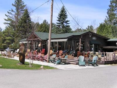
1153 State Route 86
Other Market Areas
76 TWP 11 OMT RS
154089-041-007-0001-014-000-0000
Essex
Restaurantbuilding
New York
2025
14.000
2024
0.56 AC
960401
Upstate New York Area
3,799 SF
DEMOGRAPHICS near 1153 State Route 86
1 Mile
3 Mile
5 Mile
2024 Total Population
0
1,869
12,245
2029 Population
0
1,898
12,478
Pop Growth 2024-2029
0.00%
+ 1.55%
+ 1.90%
Average Age
0
45
44
2024 Total Households
0
778
5,672
HH Growth 2024-2029
0.00%
+ 1.80%
+ 2.12%
Median Household Inc
$0
$73,196
$65,404
Avg Household Size
.00
2.00
1.90
2024 Avg HH Vehicles
.00
2.00
1.00
Median Home Value
$0
$220,370
$268,446
Median Year Built
0
1973
1969
Nearby Places
Map Layers
Map Styles
 Street
 Aerial
- Restaurants
- Banks
- Shops
- Fitness
- Groceries
SALE & LEASE HISTORY
LISTING DATE
SALE/LEASE

Sep 24, 2016
For Sale
Apr 03, 2017
For Sale
Nearby Properties
Address
Land Use
TOTAL SIZE
Lot Size
Zoning
Address
Land Use
TOTAL SIZE
Lot Size
Zoning
17,342 SF
161.99 AC
08 - GOVER
Address
Land Use
TOTAL SIZE
Lot Size
Zoning
25,000 SF
52.42 AC
08 - GOVER
Address
Land Use
TOTAL SIZE
Lot Size
Zoning
52,932 SF
140 AC
07 - MIXED
Address
Land Use
TOTAL SIZE
Lot Size
Zoning
30,991 SF
14.50 AC
07 - MIXED
Address
Land Use
TOTAL SIZE
Lot Size
Zoning
50,000 SF
4.41 AC
08 - GOVER
Address
Land Use
TOTAL SIZE
Lot Size
Zoning
68,292 SF
2.80 AC
07 - MIXED
Address
Land Use
TOTAL SIZE
Lot Size
Zoning
17,163 SF
10.70 AC
07 - MIXED
Address
Land Use
TOTAL SIZE
Lot Size
Zoning
8,960 SF
4.13 AC
07 - MIXED
Address
Land Use
TOTAL SIZE
Lot Size
Zoning
10,000 SF
98.90 AC
08 - GOVER
Address
Land Use
TOTAL SIZE
Lot Size
Zoning
66,504 SF
6.90 AC
07 - MIXED
Address
Land Use
TOTAL SIZE
Lot Size
Zoning
33,494 SF
2.91 AC
05 - COMME
Address
Land Use
TOTAL SIZE
Lot Size
Zoning
9,024 SF
9.96 AC
02 - SINGL
Address
Land Use
TOTAL SIZE
Lot Size
Zoning
19,000 SF
4.35 AC
07 - MIXED
Address
Land Use
TOTAL SIZE
Lot Size
Zoning
19,695 SF
3 AC
07 - MIXED
Address
Land Use
TOTAL SIZE
Lot Size
Zoning
Address
Land Use
TOTAL SIZE
Lot Size
Zoning
2,337 SF
123.65 AC
02 - SINGL
Address
Land Use
TOTAL SIZE
Lot Size
Zoning
1,480 SF
13.72 AC
07 - MIXED
Address
Land Use
TOTAL SIZE
Lot Size
Zoning
5,550 SF
1.30 AC
07 - MIXED
Address
Land Use
TOTAL SIZE
Lot Size
Zoning
160 AC
02 - SINGL
Address
Land Use
TOTAL SIZE
Lot Size
Zoning
160 AC
01 - NOT Z
Address
Land Use
TOTAL SIZE
Lot Size
Zoning
2,970 SF
3.94 AC
02 - SINGL
Address
Land Use
TOTAL SIZE
Lot Size
Zoning
4,096 SF
1.20 AC
07 - MIXED
Address
Land Use
TOTAL SIZE
Lot Size
Zoning
3,680 SF
6.70 AC
03 - MULTI
Address
Land Use
TOTAL SIZE
Lot Size
Zoning
6,828 SF
1.13 AC
07 - MIXED
Address
Land Use
TOTAL SIZE
Lot Size
Zoning
6,458 SF
4.66 AC
07 - MIXED
Address
Land Use
TOTAL SIZE
Lot Size
Zoning
38,718 SF
4.10 AC
07 - MIXED
Address
Land Use
TOTAL SIZE
Lot Size
Zoning
3,456 SF
1.36 AC
05 - COMME
Address
Land Use
TOTAL SIZE
Lot Size
Zoning
10.55 AC
07 - MIXED
Address
Land Use
TOTAL SIZE
Lot Size
Zoning
6,000 SF
15.50 AC
07 - MIXED
Address
Land Use
TOTAL SIZE
Lot Size
Zoning
6,593 SF
0.43 AC
07 - MIXED
The World's #1 Commercial Real Estate Marketplace
Connect with us
© 2026 CoStar Group
The information above has been obtained from sources believed reliable. While we do not doubt its accuracy we have not verified it and make no guarantee, warranty or representation about it. It is your responsibility to independently confirm its accuracy and completeness. Any projections, opinions, assumptions, or estimates used are for example only and do not represent the current or future performance of the property. The value of this transaction to you depends on tax and other factors which should be evaluated by your tax, financial, and legal advisors. You and your advisors should conduct a careful, independent investigation of the property to determine to your satisfaction the suitability of the property for your needs.