Property Record
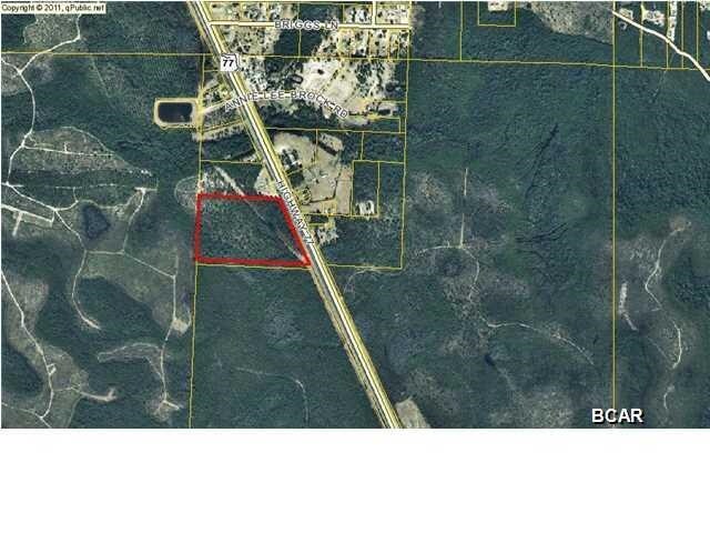
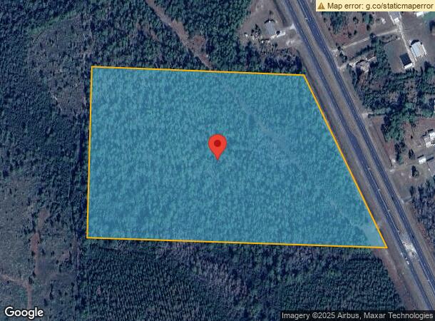
11530 Highway 77, Panama City, FL 32409
NEARBY LISTINGS FOR SALE OR LEASE
-
-
View all Panama City listings for sale on LoopNet.com
Property Detail
11530 Highway 77
07575-000-000
32 1S 14W -6.2- 85D BEG 1775 S OF NW COR OF SEC TH S 805 E 1549.4 TO R/W NLY ON HWY 77 TO PT W 1122.95 TO POB LESS HWY 77 R/W ORB 3020 P 711 ORB 4382 P 966
Vacantlandnec
Bay
A
Florida
12005C0210J
22.30 AC
2024
Panama City
2025
Other Market Areas
000201
Panama City-Panama City Beach, FL
DEMOGRAPHICS near 11530 Highway 77
1 mile
3 mile
5 mile
2024 Total Population
310
1,309
5,413
2029 Population
334
1,409
5,865
Pop Growth 2024-2029
+ 7.74%
+ 7.64%
+ 8.35%
Average Age
37
38
39
2024 Total Households
110
441
1,880
HH Growth 2024-2029
+ 9.09%
+ 8.16%
+ 8.94%
Median Household Inc
$83,654
$70,781
$58,903
Avg Household Size
2.80
2.80
2.80
2024 Avg HH Vehicles
2.00
2.00
2.00
Median Home Value
$246,153
$174,725
$175,353
Median Year Built
2002
2000
1999
Nearby Places
Map Layers
Map Styles
 Street
 Aerial
Transit
 Traffic
 Biking
Places
Listings with unknown addresses are not visible on the map
- Restaurants
- Banks
- Shops
- Fitness
- Groceries
PUBLIC TRANSPORTATION
AIRPORT
Northwest Florida Beaches International
Drive
Walk
Distance
Northwest Florida Beaches International
19 min
13.4 mi
Freight Ports
Port of Panama City
Drive
Walk
Distance
Port of Panama City
29 min
16.4 mi
SALE & LEASE HISTORY
LISTING DATE
SALE/LEASE

Sep 24, 2016
For Sale
Nearby Properties
Address
Land Use
TOTAL SIZE
Lot Size
Zoning
Address
Land Use
TOTAL SIZE
Lot Size
Zoning
202,784 SF
33.55 AC
BC14
Address
Land Use
TOTAL SIZE
Lot Size
Zoning
457.25 AC
BC15
Address
Land Use
TOTAL SIZE
Lot Size
Zoning
856.30 AC
BC02
Address
Land Use
TOTAL SIZE
Lot Size
Zoning
27,350 SF
10.31 AC
C3
Address
Land Use
TOTAL SIZE
Lot Size
Zoning
2,016 SF
112.21 AC
BC15
Address
Land Use
TOTAL SIZE
Lot Size
Zoning
297.89 AC
BC15
Address
Land Use
TOTAL SIZE
Lot Size
Zoning
644.70 AC
BC02
Address
Land Use
TOTAL SIZE
Lot Size
Zoning
243.80 AC
BC15
Address
Land Use
TOTAL SIZE
Lot Size
Zoning
5,672 SF
0.43 AC
R1
Address
Land Use
TOTAL SIZE
Lot Size
Zoning
29,009 SF
3.43 AC
BC05
Address
Land Use
TOTAL SIZE
Lot Size
Zoning
1,380 SF
270.44 AC
BC02
Address
Land Use
TOTAL SIZE
Lot Size
Zoning
3,990 SF
12 AC
BC02
Address
Land Use
TOTAL SIZE
Lot Size
Zoning
8,468 SF
1.70 AC
BC15
Address
Land Use
TOTAL SIZE
Lot Size
Zoning
24,175 SF
2.81 AC
BC05
Address
Land Use
TOTAL SIZE
Lot Size
Zoning
5,688 SF
0.52 AC
R1
Address
Land Use
TOTAL SIZE
Lot Size
Zoning
110.03 AC
BC02
Address
Land Use
TOTAL SIZE
Lot Size
Zoning
92.64 AC
BC15
Address
Land Use
TOTAL SIZE
Lot Size
Zoning
12,610 SF
2.35 AC
BC14
Address
Land Use
TOTAL SIZE
Lot Size
Zoning
6,951 SF
1.97 AC
R1
Address
Land Use
TOTAL SIZE
Lot Size
Zoning
2,560 SF
56.20 AC
BC02
Address
Land Use
TOTAL SIZE
Lot Size
Zoning
1,518 SF
26.74 AC
BC15
Address
Land Use
TOTAL SIZE
Lot Size
Zoning
2,802 SF
29.54 AC
BC08
Address
Land Use
TOTAL SIZE
Lot Size
Zoning
1,856 SF
10.01 AC
BC02
Address
Land Use
TOTAL SIZE
Lot Size
Zoning
102.14 AC
BC15
Address
Land Use
TOTAL SIZE
Lot Size
Zoning
5,070 SF
12.99 AC
Address
Land Use
TOTAL SIZE
Lot Size
Zoning
3,898 SF
0.89 AC
R1
Address
Land Use
TOTAL SIZE
Lot Size
Zoning
4,689 SF
11.67 AC
Address
Land Use
TOTAL SIZE
Lot Size
Zoning
3,988 SF
0.95 AC
BC15
Address
Land Use
TOTAL SIZE
Lot Size
Zoning
4,792 SF
139.67 AC
BC14
Address
Land Use
TOTAL SIZE
Lot Size
Zoning
3,271 SF
0.79 AC
R1
The World's #1 Commercial Real Estate Marketplace
Connect with us
© 2026 CoStar Group
The information above has been obtained from sources believed reliable. While we do not doubt its accuracy we have not verified it and make no guarantee, warranty or representation about it. It is your responsibility to independently confirm its accuracy and completeness. Any projections, opinions, assumptions, or estimates used are for example only and do not represent the current or future performance of the property. The value of this transaction to you depends on tax and other factors which should be evaluated by your tax, financial, and legal advisors. You and your advisors should conduct a careful, independent investigation of the property to determine to your satisfaction the suitability of the property for your needs.