Property Record
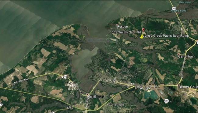
11535 Smiths Neck Rd, Carrollton, VA 23314

NEARBY LISTINGS FOR SALE OR LEASE
-
-
View all Carrollton listings for sale on LoopNet.com
Property Detail
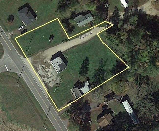
11535 Smiths Neck Rd
Virginia Beach-Norfolk-Newport News, VA-NC
C Murphy Estate
23-01-077B
STORE LOT-G C MURPHY EST PLAT 2-48-4
Commercialnec
Isle of Wight
X
Virginia
51093C0156E
c
2025
0.96 AC
2025
Smithfield
280108
Hampton Roads
1,176 SF
DEMOGRAPHICS near 11535 Smiths Neck Rd
1 Mile
3 Mile
5 Mile
2024 Total Population
1,148
11,401
22,539
2029 Population
1,237
12,306
24,608
Pop Growth 2024-2029
+ 7.75%
+ 7.94%
+ 9.18%
Average Age
40
41
42
2024 Total Households
470
4,415
8,744
HH Growth 2024-2029
+ 7.45%
+ 7.84%
+ 9.06%
Median Household Inc
$93,115
$105,020
$99,732
Avg Household Size
2.40
2.60
2.60
2024 Avg HH Vehicles
2.00
2.00
2.00
Median Home Value
$384,210
$365,404
$358,362
Median Year Built
2000
1996
1994
Nearby Places
Map Layers
Map Styles
 Street
 Aerial
- Restaurants
- Banks
- Shops
- Fitness
- Groceries
PUBLIC TRANSPORTATION
COMMUTER RAIL
Newport News (Northeast Regional - Amtrak)
DRIVE
WALK
Distance
Newport News (Northeast Regional - Amtrak)
16 min
9.2 mi
AIRPORT
Newport News/Williamsburg International
DRIVE
WALK
Distance
Newport News/Williamsburg International
34 min
18.3 mi
Norfolk International
DRIVE
WALK
Distance
Norfolk International
48 min
27.9 mi
Freight Ports
Virginia Port Authority - Newport News
DRIVE
WALK
Distance
Virginia Port Authority - Newport News
21 min
11.7 mi
SALE & LEASE HISTORY
LISTING DATE
SALE/LEASE

Sep 23, 2016
For Sale
Mar 03, 2017
For Sale
Aug 08, 2019
For Sale
Nearby Properties
Address
Land Use
TOTAL SIZE
Lot Size
Zoning
Address
Land Use
TOTAL SIZE
Lot Size
Zoning
9,600 SF
17.35 AC
PDR
Address
Land Use
TOTAL SIZE
Lot Size
Zoning
3,998 SF
15.79 AC
01
Address
Land Use
TOTAL SIZE
Lot Size
Zoning
13,368 SF
19.96 AC
PDR
Address
Land Use
TOTAL SIZE
Lot Size
Zoning
51,086 SF
43.12 AC
01
Address
Land Use
TOTAL SIZE
Lot Size
Zoning
99,606 SF
34.89 AC
RAC
Address
Land Use
TOTAL SIZE
Lot Size
Zoning
77,001 SF
13.97 AC
01
Address
Land Use
TOTAL SIZE
Lot Size
Zoning
57,513 SF
11.37 AC
Address
Land Use
TOTAL SIZE
Lot Size
Zoning
58,368 SF
2.51 AC
TOWN
Address
Land Use
TOTAL SIZE
Lot Size
Zoning
22,750 SF
19.51 AC
RAC
Address
Land Use
TOTAL SIZE
Lot Size
Zoning
99.89 AC
01
Address
Land Use
TOTAL SIZE
Lot Size
Zoning
13,512 SF
8.07 AC
TOWN
Address
Land Use
TOTAL SIZE
Lot Size
Zoning
4,900 SF
1.17 AC
Address
Land Use
TOTAL SIZE
Lot Size
Zoning
3,236 SF
55.59 AC
01
Address
Land Use
TOTAL SIZE
Lot Size
Zoning
25,200 SF
4.71 AC
01
Address
Land Use
TOTAL SIZE
Lot Size
Zoning
11,187 SF
2.74 AC
01
Address
Land Use
TOTAL SIZE
Lot Size
Zoning
7,127 SF
22.64 AC
TOWN
Address
Land Use
TOTAL SIZE
Lot Size
Zoning
13,460 SF
3.47 AC
TOWN
Address
Land Use
TOTAL SIZE
Lot Size
Zoning
4,744 SF
5.11 AC
Address
Land Use
TOTAL SIZE
Lot Size
Zoning
110 AC
RAC
Address
Land Use
TOTAL SIZE
Lot Size
Zoning
183.37 AC
RAC
Address
Land Use
TOTAL SIZE
Lot Size
Zoning
13,512 SF
9.75 AC
TOWN
Address
Land Use
TOTAL SIZE
Lot Size
Zoning
150.60 AC
TOWN
Address
Land Use
TOTAL SIZE
Lot Size
Zoning
11,114 SF
2.42 AC
TOWN
Address
Land Use
TOTAL SIZE
Lot Size
Zoning
17,500 SF
2.58 AC
TOWN
Address
Land Use
TOTAL SIZE
Lot Size
Zoning
5,723 SF
25.06 AC
TOWN
Address
Land Use
TOTAL SIZE
Lot Size
Zoning
247.99 AC
RAC
Address
Land Use
TOTAL SIZE
Lot Size
Zoning
26,922 SF
4.33 AC
01
Address
Land Use
TOTAL SIZE
Lot Size
Zoning
36,840 SF
3.44 AC
TOWN
Address
Land Use
TOTAL SIZE
Lot Size
Zoning
3,050 SF
2.48 AC
01
Address
Land Use
TOTAL SIZE
Lot Size
Zoning
3,340 SF
2.23 AC
01
The World's #1 Commercial Real Estate Marketplace
Connect with us
© 2025 CoStar Group
The information above has been obtained from sources believed reliable. While we do not doubt its accuracy we have not verified it and make no guarantee, warranty or representation about it. It is your responsibility to independently confirm its accuracy and completeness. Any projections, opinions, assumptions, or estimates used are for example only and do not represent the current or future performance of the property. The value of this transaction to you depends on tax and other factors which should be evaluated by your tax, financial, and legal advisors. You and your advisors should conduct a careful, independent investigation of the property to determine to your satisfaction the suitability of the property for your needs.