Property Record
11540 Dunkirk St, Saint Albans, NY 11412

NEARBY LISTINGS FOR SALE OR LEASE
Property Detail
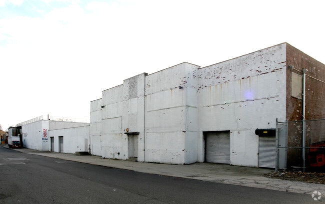
11540 Dunkirk St
10315-0135
Map Terrace At St Albans
Warehouse
Queens
X
New York
3604970234F
135
2024
1.39 AC
2025
South Queens
042400
Long Island (New York)
57,201 SF
New York-Jersey City-White Plains, NY-NJ
DEMOGRAPHICS near 11540 Dunkirk St
1 mile
3 mile
5 mile
2024 Total Population
55,907
507,805
1,128,986
2029 Population
51,142
470,959
1,054,075
Pop Growth 2024-2029
(8.52%)
(7.26%)
(6.64%)
Average Age
42
41
42
2024 Total Households
16,944
156,050
369,238
HH Growth 2024-2029
(9.13%)
(7.56%)
(6.86%)
Median Household Inc
$83,590
$78,804
$85,299
Avg Household Size
3.10
3.10
2.90
2024 Avg HH Vehicles
1.00
1.00
1.00
Median Home Value
$606,258
$639,149
$661,103
Median Year Built
1948
1951
1951
Nearby Places
Map Layers
Map Styles
 Street
 Aerial
Transit
 Traffic
 Biking
Places
Listings with unknown addresses are not visible on the map
- Restaurants
- Banks
- Shops
- Fitness
- Groceries
PUBLIC TRANSPORTATION
COMMUTER RAIL
Saint Albans Station (West Hempstead Branch - Long Island Rail Road)
Drive
Walk
Distance
Saint Albans Station (West Hempstead Branch - Long Island Rail Road)
2 min
3 min
0.2 mi
Hillside Facility (Hempstead Branch - Long Island Rail Road, Montauk Branch - Long Island Rail Road, Oyster Bay Branch - Long Island Rail Road, Port Jefferson Branch - Long Island Rail Road, Ronkonkoma Branch - Long Island Rail Road)
Drive
Walk
Distance
Hillside Facility (Hempstead Branch - Long Island Rail Road, Montauk Branch - Long Island Rail Road, Oyster Bay Branch - Long Island Rail Road, Port Jefferson Branch - Long Island Rail Road, Ronkonkoma Branch - Long Island Rail Road)
2 min
1.1 mi
AIRPORT
John F Kennedy International
Drive
Walk
Distance
John F Kennedy International
11 min
6.6 mi
LaGuardia
Drive
Walk
Distance
LaGuardia
17 min
10.2 mi
Newark Liberty International
Drive
Walk
Distance
Newark Liberty International
44 min
29.9 mi
Freight Ports
NY - Red Hook Container Terminal
Drive
Walk
Distance
NY - Red Hook Container Terminal
29 min
18.7 mi
Nearby Properties
Address
Land Use
TOTAL SIZE
Lot Size
Zoning
Address
Land Use
TOTAL SIZE
Lot Size
Zoning
107.28 AC
R6
Address
Land Use
TOTAL SIZE
Lot Size
Zoning
107.28 AC
R6
Address
Land Use
TOTAL SIZE
Lot Size
Zoning
107.28 AC
R6
Address
Land Use
TOTAL SIZE
Lot Size
Zoning
4,528,000 SF
94.27 AC
R4
Address
Land Use
TOTAL SIZE
Lot Size
Zoning
6,940,450 SF
107.28 AC
R6
Address
Land Use
TOTAL SIZE
Lot Size
Zoning
1,069,367 SF
14.65 AC
R4
Address
Land Use
TOTAL SIZE
Lot Size
Zoning
532,011 SF
2.48 AC
R6
Address
Land Use
TOTAL SIZE
Lot Size
Zoning
294.47 AC
PARK
Address
Land Use
TOTAL SIZE
Lot Size
Zoning
13,500 SF
104 AC
PARK
Address
Land Use
TOTAL SIZE
Lot Size
Zoning
731,247 SF
56.09 AC
R3-2
Address
Land Use
TOTAL SIZE
Lot Size
Zoning
738,000 SF
1.92 AC
C6-3
Address
Land Use
TOTAL SIZE
Lot Size
Zoning
291,589 SF
1.55 AC
C6-3
Address
Land Use
TOTAL SIZE
Lot Size
Zoning
82.92 AC
PARK
Address
Land Use
TOTAL SIZE
Lot Size
Zoning
704,500 SF
36.37 AC
R4
Address
Land Use
TOTAL SIZE
Lot Size
Zoning
704,500 SF
36.37 AC
R4
Address
Land Use
TOTAL SIZE
Lot Size
Zoning
704,500 SF
36.37 AC
R4
Address
Land Use
TOTAL SIZE
Lot Size
Zoning
704,500 SF
36.37 AC
R4
Address
Land Use
TOTAL SIZE
Lot Size
Zoning
704,500 SF
36.37 AC
R4
Address
Land Use
TOTAL SIZE
Lot Size
Zoning
704,500 SF
36.37 AC
R4
Address
Land Use
TOTAL SIZE
Lot Size
Zoning
704,500 SF
36.37 AC
R4
Address
Land Use
TOTAL SIZE
Lot Size
Zoning
704,500 SF
36.37 AC
R4
Address
Land Use
TOTAL SIZE
Lot Size
Zoning
704,500 SF
36.37 AC
R4
Address
Land Use
TOTAL SIZE
Lot Size
Zoning
704,500 SF
36.37 AC
R4
Address
Land Use
TOTAL SIZE
Lot Size
Zoning
704,500 SF
36.37 AC
R4
Address
Land Use
TOTAL SIZE
Lot Size
Zoning
704,500 SF
36.37 AC
R4
Address
Land Use
TOTAL SIZE
Lot Size
Zoning
704,500 SF
36.37 AC
R4
Address
Land Use
TOTAL SIZE
Lot Size
Zoning
704,500 SF
36.37 AC
R4
Address
Land Use
TOTAL SIZE
Lot Size
Zoning
704,500 SF
36.37 AC
R4
Address
Land Use
TOTAL SIZE
Lot Size
Zoning
704,500 SF
36.37 AC
R4
Address
Land Use
TOTAL SIZE
Lot Size
Zoning
704,500 SF
36.37 AC
R4
The World's #1 Commercial Real Estate Marketplace
Connect with us
© 2026 CoStar Group
The information above has been obtained from sources believed reliable. While we do not doubt its accuracy we have not verified it and make no guarantee, warranty or representation about it. It is your responsibility to independently confirm its accuracy and completeness. Any projections, opinions, assumptions, or estimates used are for example only and do not represent the current or future performance of the property. The value of this transaction to you depends on tax and other factors which should be evaluated by your tax, financial, and legal advisors. You and your advisors should conduct a careful, independent investigation of the property to determine to your satisfaction the suitability of the property for your needs.