Property Record
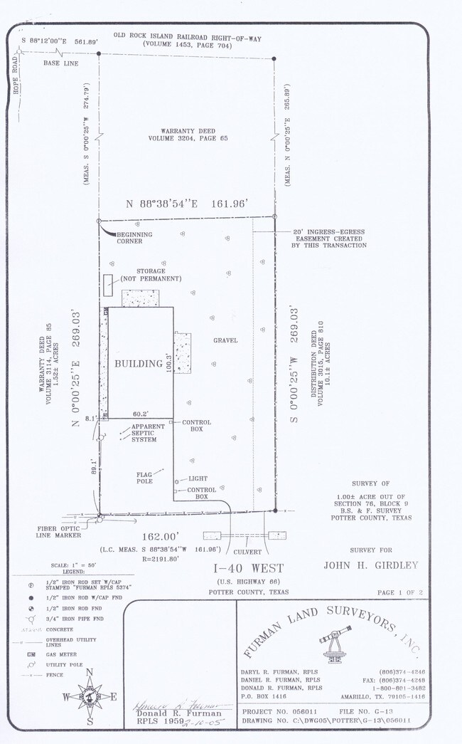
11540 W Interstate 40, Amarillo, TX 79124

Property Detail
11540 W Interstate 40
R-370-0760-7810-0
SECT 76 B S & F BLK 0009, 1 AC TR BEG 561 FT E OF INTERSECTION OF E ROW OF HOPE RD & S RR ROW, 1.0000 ACRES
Warehouse
Potter
B and X Area of moderate flood hazard, usually the area between the limits of the 100-year and 500-year floods.
Texas
2024
1 AC
2025
Amarillo
014300
Other Market Areas
6,000 SF
Amarillo, TX
NEARBY LISTINGS FOR SALE OR LEASE
DEMOGRAPHICS near 11540 W Interstate 40
1 mile
3 mile
5 mile
2024 Total Population
435
8,145
62,691
2029 Population
448
8,445
64,541
Pop Growth 2024-2029
+ 2.99%
+ 3.68%
+ 2.95%
Average Age
39
43
41
2024 Total Households
146
3,480
26,145
HH Growth 2024-2029
+ 2.74%
+ 3.71%
+ 2.90%
Median Household Inc
$134,895
$78,762
$81,863
Avg Household Size
2.90
2.20
2.30
2024 Avg HH Vehicles
3.00
2.00
2.00
Median Home Value
$396,153
$284,062
$265,275
Median Year Built
2009
1986
1983
Nearby Places
Map Layers
Map Styles
 Street
 Aerial
Transit
 Traffic
 Biking
Places
Listings with unknown addresses are not visible on the map
- Restaurants
- Banks
- Shops
- Fitness
- Groceries
PUBLIC TRANSPORTATION
AIRPORT
Rick Husband Amarillo International
Drive
Walk
Distance
Rick Husband Amarillo International
27 min
17.3 mi
Nearby Properties
Address
Land Use
TOTAL SIZE
Lot Size
Zoning
Address
Land Use
TOTAL SIZE
Lot Size
Zoning
343,998 SF
19.99 AC
PD
Address
Land Use
TOTAL SIZE
Lot Size
Zoning
202,800 SF
6.57 AC
Address
Land Use
TOTAL SIZE
Lot Size
Zoning
270,379 SF
12.12 AC
Address
Land Use
TOTAL SIZE
Lot Size
Zoning
485,065 SF
38.89 AC
Address
Land Use
TOTAL SIZE
Lot Size
Zoning
485,065 SF
38.89 AC
Address
Land Use
TOTAL SIZE
Lot Size
Zoning
145,819 SF
12.89 AC
PD
Address
Land Use
TOTAL SIZE
Lot Size
Zoning
52,473 SF
5.67 AC
Address
Land Use
TOTAL SIZE
Lot Size
Zoning
100,099 SF
3 AC
HC
Address
Land Use
TOTAL SIZE
Lot Size
Zoning
54,653 SF
5.45 AC
Address
Land Use
TOTAL SIZE
Lot Size
Zoning
49,647 SF
3.67 AC
Address
Land Use
TOTAL SIZE
Lot Size
Zoning
200,117 SF
7.96 AC
GR
Address
Land Use
TOTAL SIZE
Lot Size
Zoning
89,173 SF
9.55 AC
PD
Address
Land Use
TOTAL SIZE
Lot Size
Zoning
69,009 SF
37.97 AC
Address
Land Use
TOTAL SIZE
Lot Size
Zoning
96,538 SF
11.33 AC
PD
Address
Land Use
TOTAL SIZE
Lot Size
Zoning
204,310 SF
12.50 AC
A
Address
Land Use
TOTAL SIZE
Lot Size
Zoning
49,709 SF
2.71 AC
PD
Address
Land Use
TOTAL SIZE
Lot Size
Zoning
73,558 SF
3.09 AC
Address
Land Use
TOTAL SIZE
Lot Size
Zoning
139,360 SF
77.61 AC
Address
Land Use
TOTAL SIZE
Lot Size
Zoning
70,837 SF
10 AC
R2
Address
Land Use
TOTAL SIZE
Lot Size
Zoning
78,465 SF
14.42 AC
GR
Address
Land Use
TOTAL SIZE
Lot Size
Zoning
69,100 SF
11.93 AC
Address
Land Use
TOTAL SIZE
Lot Size
Zoning
160,224 SF
11.32 AC
PD
Address
Land Use
TOTAL SIZE
Lot Size
Zoning
41,600 SF
10.39 AC
Address
Land Use
TOTAL SIZE
Lot Size
Zoning
64,862 SF
5.92 AC
Address
Land Use
TOTAL SIZE
Lot Size
Zoning
64,129 SF
1.79 AC
HC
Address
Land Use
TOTAL SIZE
Lot Size
Zoning
67,930 SF
4.20 AC
Address
Land Use
TOTAL SIZE
Lot Size
Zoning
89,713 SF
11.20 AC
PO
Address
Land Use
TOTAL SIZE
Lot Size
Zoning
138,512 SF
17.38 AC
Address
Land Use
TOTAL SIZE
Lot Size
Zoning
33,664 SF
5.30 AC
O
The World's #1 Commercial Real Estate Marketplace
Connect with us
© 2026 CoStar Group
The information above has been obtained from sources believed reliable. While we do not doubt its accuracy we have not verified it and make no guarantee, warranty or representation about it. It is your responsibility to independently confirm its accuracy and completeness. Any projections, opinions, assumptions, or estimates used are for example only and do not represent the current or future performance of the property. The value of this transaction to you depends on tax and other factors which should be evaluated by your tax, financial, and legal advisors. You and your advisors should conduct a careful, independent investigation of the property to determine to your satisfaction the suitability of the property for your needs.