Property Record
11544 Highway 280, Sterrett, AL 35147
NEARBY LISTINGS FOR SALE OR LEASE
-
-
View all Sterrett listings for sale on LoopNet.com
Property Detail
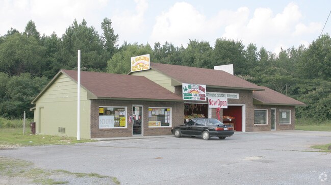
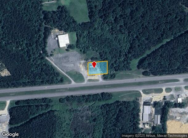
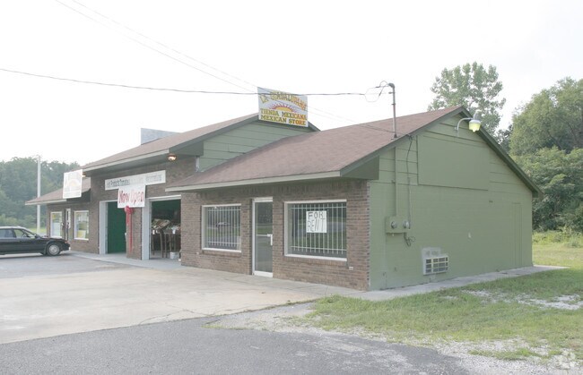
11544 Highway 280
08-8-28-0-001-024-003
COM INT N ROW U S HWY 280 & W LN NE1/4 W 475 TO POB CONT W 221 N 150 E 221 S 150 TO POB S28 T19S R1E
Autorepair
Shelby
A
Alabama
01117C0256E
0.76 AC
2024
Chelsea/Harpersville
2024
Birmingham
030215
Birmingham-Hoover, AL
2,352 SF
DEMOGRAPHICS near 11544 Highway 280
1 Mile
3 Mile
5 Mile
2024 Total Population
469
6,324
10,987
2029 Population
513
7,005
12,127
Pop Growth 2024-2029
+ 9.38%
+ 10.77%
+ 10.38%
Average Age
41
39
39
2024 Total Households
178
2,343
4,066
HH Growth 2024-2029
+ 9.55%
+ 10.93%
+ 10.53%
Median Household Inc
$79,934
$93,642
$91,993
Avg Household Size
2.60
2.70
2.70
2024 Avg HH Vehicles
2.00
2.00
2.00
Median Home Value
$267,499
$303,598
$293,835
Median Year Built
2002
2006
2005
Nearby Places
Map Layers
Map Styles
 Street
 Aerial
- Restaurants
- Banks
- Shops
- Fitness
- Groceries
PUBLIC TRANSPORTATION
AIRPORT
Birmingham-Shuttlesworth International
DRIVE
WALK
Distance
Birmingham-Shuttlesworth International
38 min
26.8 mi
Freight Ports
Port of Mobile
DRIVE
WALK
Distance
Port of Mobile
284 min
254.6 mi
Nearby Properties
Address
Land Use
TOTAL SIZE
Lot Size
Zoning
Address
Land Use
TOTAL SIZE
Lot Size
Zoning
109,954 SF
16 AC
Address
Land Use
TOTAL SIZE
Lot Size
Zoning
15,366 SF
15 AC
Address
Land Use
TOTAL SIZE
Lot Size
Zoning
17,199 SF
10 AC
Address
Land Use
TOTAL SIZE
Lot Size
Zoning
6,930 SF
2.42 AC
Address
Land Use
TOTAL SIZE
Lot Size
Zoning
720 SF
88 AC
Address
Land Use
TOTAL SIZE
Lot Size
Zoning
14,216 SF
4.60 AC
Address
Land Use
TOTAL SIZE
Lot Size
Zoning
4,000 SF
5.03 AC
Address
Land Use
TOTAL SIZE
Lot Size
Zoning
16,450 SF
10 AC
Address
Land Use
TOTAL SIZE
Lot Size
Zoning
Address
Land Use
TOTAL SIZE
Lot Size
Zoning
3,120 SF
2.97 AC
Address
Land Use
TOTAL SIZE
Lot Size
Zoning
Address
Land Use
TOTAL SIZE
Lot Size
Zoning
5,000 SF
3.27 AC
Address
Land Use
TOTAL SIZE
Lot Size
Zoning
2,475 SF
1.82 AC
Address
Land Use
TOTAL SIZE
Lot Size
Zoning
9,037 SF
1.21 AC
Address
Land Use
TOTAL SIZE
Lot Size
Zoning
12,100 SF
2.50 AC
Address
Land Use
TOTAL SIZE
Lot Size
Zoning
3,200 SF
1.96 AC
Address
Land Use
TOTAL SIZE
Lot Size
Zoning
2,254 SF
8.60 AC
Address
Land Use
TOTAL SIZE
Lot Size
Zoning
7,000 SF
5.10 AC
Address
Land Use
TOTAL SIZE
Lot Size
Zoning
5,440 SF
4.70 AC
Address
Land Use
TOTAL SIZE
Lot Size
Zoning
1,988 SF
5 AC
Address
Land Use
TOTAL SIZE
Lot Size
Zoning
3,092 SF
3 AC
Address
Land Use
TOTAL SIZE
Lot Size
Zoning
Address
Land Use
TOTAL SIZE
Lot Size
Zoning
6,000 SF
2.54 AC
Address
Land Use
TOTAL SIZE
Lot Size
Zoning
2,500 SF
2.40 AC
Address
Land Use
TOTAL SIZE
Lot Size
Zoning
600 SF
1.42 AC
Address
Land Use
TOTAL SIZE
Lot Size
Zoning
6,385 SF
0.93 AC
Address
Land Use
TOTAL SIZE
Lot Size
Zoning
6,161 SF
1.04 AC
Address
Land Use
TOTAL SIZE
Lot Size
Zoning
1,752 SF
2 AC
Address
Land Use
TOTAL SIZE
Lot Size
Zoning
The World's #1 Commercial Real Estate Marketplace
Connect with us
© 2025 CoStar Group
The information above has been obtained from sources believed reliable. While we do not doubt its accuracy we have not verified it and make no guarantee, warranty or representation about it. It is your responsibility to independently confirm its accuracy and completeness. Any projections, opinions, assumptions, or estimates used are for example only and do not represent the current or future performance of the property. The value of this transaction to you depends on tax and other factors which should be evaluated by your tax, financial, and legal advisors. You and your advisors should conduct a careful, independent investigation of the property to determine to your satisfaction the suitability of the property for your needs.