Property Record
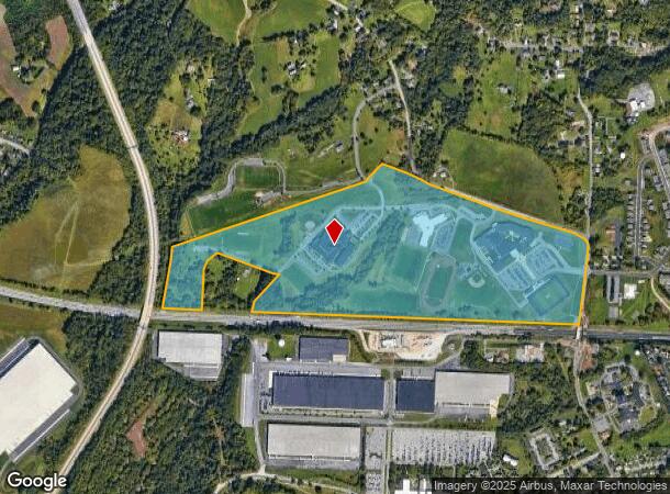
1155 N Union St, Middletown, PA 17057
NEARBY LISTINGS FOR SALE OR LEASE
Property Detail
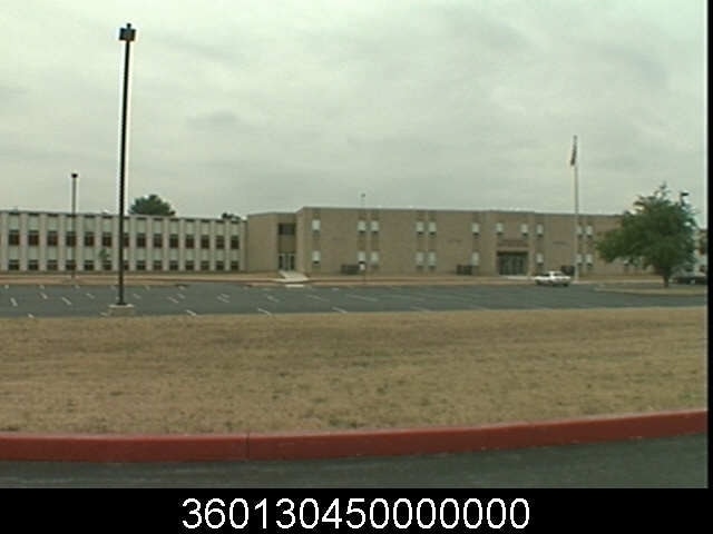
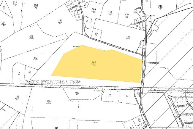
1155 N Union St
36-013-045
Middletown Area Sch District
University
Dauphin
X
Pennsylvania
42043C0453D
117.61 AC
2025
Harrisburg Area East
2025
Philadelphia
023602
Harrisburg-Carlisle, PA
72,186 SF
DEMOGRAPHICS near 1155 N Union St
1 Mile
3 Mile
5 Mile
2024 Total Population
5,545
28,358
70,258
2029 Population
5,685
28,780
71,484
Pop Growth 2024-2029
+ 2.52%
+ 1.49%
+ 1.74%
Average Age
41
40
40
2024 Total Households
2,162
11,476
28,205
HH Growth 2024-2029
+ 2.68%
+ 1.52%
+ 1.82%
Median Household Inc
$68,697
$69,378
$75,074
Avg Household Size
2.20
2.30
2.40
2024 Avg HH Vehicles
2.00
2.00
2.00
Median Home Value
$147,823
$176,220
$194,742
Median Year Built
1959
1973
1975
Nearby Places
Map Layers
Map Styles
 Street
 Aerial
- Restaurants
- Banks
- Shops
- Fitness
- Groceries
PUBLIC TRANSPORTATION
COMMUTER RAIL
Middletown (Keystone Service - Amtrak)
DRIVE
WALK
Distance
Middletown (Keystone Service - Amtrak)
7 min
2.6 mi
Harrisburg (Keystone Service - Amtrak, Pennsylvanian - Amtrak)
DRIVE
WALK
Distance
Harrisburg (Keystone Service - Amtrak, Pennsylvanian - Amtrak)
18 min
9.9 mi
AIRPORT
Harrisburg International
DRIVE
WALK
Distance
Harrisburg International
11 min
4.1 mi
Freight Ports
Port of Baltimore
DRIVE
WALK
Distance
Port of Baltimore
120 min
85.8 mi
Nearby Properties
Address
Land Use
TOTAL SIZE
Lot Size
Zoning
Address
Land Use
TOTAL SIZE
Lot Size
Zoning
5,737 SF
592.08 AC
Address
Land Use
TOTAL SIZE
Lot Size
Zoning
185,784 SF
173.81 AC
Address
Land Use
TOTAL SIZE
Lot Size
Zoning
240,000 SF
68.73 AC
Address
Land Use
TOTAL SIZE
Lot Size
Zoning
29,440 SF
82.92 AC
Address
Land Use
TOTAL SIZE
Lot Size
Zoning
3,029 SF
54.26 AC
Address
Land Use
TOTAL SIZE
Lot Size
Zoning
142,010 SF
53.46 AC
Address
Land Use
TOTAL SIZE
Lot Size
Zoning
50,963 SF
46.61 AC
Address
Land Use
TOTAL SIZE
Lot Size
Zoning
5,396 SF
49.35 AC
Address
Land Use
TOTAL SIZE
Lot Size
Zoning
651,250 SF
47.13 AC
Address
Land Use
TOTAL SIZE
Lot Size
Zoning
40,000 SF
48.30 AC
Address
Land Use
TOTAL SIZE
Lot Size
Zoning
1,196 SF
50.34 AC
Address
Land Use
TOTAL SIZE
Lot Size
Zoning
507,000 SF
32.82 AC
Address
Land Use
TOTAL SIZE
Lot Size
Zoning
2,068 SF
19.26 AC
Address
Land Use
TOTAL SIZE
Lot Size
Zoning
348,615 SF
38.98 AC
Address
Land Use
TOTAL SIZE
Lot Size
Zoning
Address
Land Use
TOTAL SIZE
Lot Size
Zoning
165,549 SF
65.10 AC
Address
Land Use
TOTAL SIZE
Lot Size
Zoning
2,400 SF
9.11 AC
Address
Land Use
TOTAL SIZE
Lot Size
Zoning
320,000 SF
16.71 AC
Address
Land Use
TOTAL SIZE
Lot Size
Zoning
83,505 SF
11.50 AC
Address
Land Use
TOTAL SIZE
Lot Size
Zoning
18.43 AC
Address
Land Use
TOTAL SIZE
Lot Size
Zoning
249,112 SF
24.01 AC
Address
Land Use
TOTAL SIZE
Lot Size
Zoning
132,588 SF
18.49 AC
Address
Land Use
TOTAL SIZE
Lot Size
Zoning
59,760 SF
61.67 AC
Address
Land Use
TOTAL SIZE
Lot Size
Zoning
137,640 SF
12.87 AC
Address
Land Use
TOTAL SIZE
Lot Size
Zoning
3,698 SF
250.35 AC
Address
Land Use
TOTAL SIZE
Lot Size
Zoning
56.58 AC
Address
Land Use
TOTAL SIZE
Lot Size
Zoning
186,000 SF
10.58 AC
Address
Land Use
TOTAL SIZE
Lot Size
Zoning
37,224 SF
12.57 AC
Address
Land Use
TOTAL SIZE
Lot Size
Zoning
214,400 SF
14.74 AC
The World's #1 Commercial Real Estate Marketplace
Connect with us
© 2026 CoStar Group
The information above has been obtained from sources believed reliable. While we do not doubt its accuracy we have not verified it and make no guarantee, warranty or representation about it. It is your responsibility to independently confirm its accuracy and completeness. Any projections, opinions, assumptions, or estimates used are for example only and do not represent the current or future performance of the property. The value of this transaction to you depends on tax and other factors which should be evaluated by your tax, financial, and legal advisors. You and your advisors should conduct a careful, independent investigation of the property to determine to your satisfaction the suitability of the property for your needs.