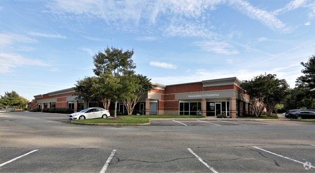
Property Record
11551 Nuckols Rd, Glen Allen, VA 23059

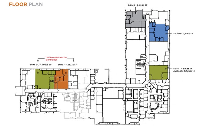

Current Lease Availabilities
NEARBY LISTINGS FOR SALE OR LEASE
Property Detail
11551 Nuckols Rd
744-775-3543
00100A0000 0023A; NUCKOLS RD AC 6.213 76 A1 43
Officebuilding
Henrico
X
Virginia
51085C0278C
6.21 AC
2025
Innsbrook
2025
Richmond VA
200148
Richmond, VA
67,667 SF
DEMOGRAPHICS near 11551 Nuckols Rd
1 Mile
3 Mile
5 Mile
2024 Total Population
8,176
39,970
109,578
2029 Population
8,122
39,998
109,794
Pop Growth 2024-2029
(0.66%)
+ 0.07%
+ 0.20%
Average Age
37
37
40
2024 Total Households
2,769
13,918
41,636
HH Growth 2024-2029
(0.72%)
+ 0.11%
+ 0.20%
Median Household Inc
$165,511
$161,543
$118,559
Avg Household Size
2.90
2.80
2.60
2024 Avg HH Vehicles
2.00
2.00
2.00
Median Home Value
$590,513
$533,993
$441,933
Median Year Built
2001
2003
1994
Nearby Places
- Restaurants
- Banks
- Shops
- Fitness
- Groceries
PUBLIC TRANSPORTATION
COMMUTER RAIL
DRIVE
WALK
Distance
15 min
9.4 mi
AIRPORT
Richmond International
DRIVE
WALK
Distance
Richmond International
36 min
27.0 mi
Nearby Properties
Address
Land Use
TOTAL SIZE
Lot Size
Zoning
Address
Land Use
TOTAL SIZE
Lot Size
Zoning
10,290 SF
56.53 AC
B-3C
Address
Land Use
TOTAL SIZE
Lot Size
Zoning
37.36 AC
R-5C
Address
Land Use
TOTAL SIZE
Lot Size
Zoning
112,224 SF
20.53 AC
MIXE
Address
Land Use
TOTAL SIZE
Lot Size
Zoning
57,104 SF
0.02 AC
UMUC
Address
Land Use
TOTAL SIZE
Lot Size
Zoning
403,784 SF
40.74 AC
MIXE
Address
Land Use
TOTAL SIZE
Lot Size
Zoning
417,042 SF
49.96 AC
O-3C
Address
Land Use
TOTAL SIZE
Lot Size
Zoning
254,325 SF
60.28 AC
A-1
Address
Land Use
TOTAL SIZE
Lot Size
Zoning
340 SF
23.32 AC
MIXE
Address
Land Use
TOTAL SIZE
Lot Size
Zoning
278,084 SF
21.70 AC
R-6C
Address
Land Use
TOTAL SIZE
Lot Size
Zoning
309,156 SF
17.13 AC
R-6
Address
Land Use
TOTAL SIZE
Lot Size
Zoning
282,400 SF
18.71 AC
MIXE
Address
Land Use
TOTAL SIZE
Lot Size
Zoning
138,713 SF
46.53 AC
A-1
Address
Land Use
TOTAL SIZE
Lot Size
Zoning
326,755 SF
36.20 AC
O-3C
Address
Land Use
TOTAL SIZE
Lot Size
Zoning
5,590 SF
11.54 AC
B-2C
Address
Land Use
TOTAL SIZE
Lot Size
Zoning
358,228 SF
3.30 AC
UMUC
Address
Land Use
TOTAL SIZE
Lot Size
Zoning
55,769 SF
14.13 AC
MIXE
Address
Land Use
TOTAL SIZE
Lot Size
Zoning
111,487 SF
2.92 AC
B-2C
Address
Land Use
TOTAL SIZE
Lot Size
Zoning
23,378 SF
0.02 AC
UMUC
Address
Land Use
TOTAL SIZE
Lot Size
Zoning
164,680 SF
33.86 AC
MIXE
Address
Land Use
TOTAL SIZE
Lot Size
Zoning
20,864 SF
15.28 AC
MIXE
Address
Land Use
TOTAL SIZE
Lot Size
Zoning
133,179 SF
26.01 AC
M-1
Address
Land Use
TOTAL SIZE
Lot Size
Zoning
117,605 SF
29.24 AC
A-1
Address
Land Use
TOTAL SIZE
Lot Size
Zoning
58,446 SF
12.71 AC
B-3C
Address
Land Use
TOTAL SIZE
Lot Size
Zoning
187,283 SF
5.22 AC
B-2C
Address
Land Use
TOTAL SIZE
Lot Size
Zoning
10,354 SF
14.83 AC
B-2C
Address
Land Use
TOTAL SIZE
Lot Size
Zoning
1.92 AC
UMUC
Address
Land Use
TOTAL SIZE
Lot Size
Zoning
200,559 SF
17.99 AC
M-1
Address
Land Use
TOTAL SIZE
Lot Size
Zoning
154,014 SF
6.66 AC
MIXE
Address
Land Use
TOTAL SIZE
Lot Size
Zoning
2,198 SF
48.46 AC
A-1
Address
Land Use
TOTAL SIZE
Lot Size
Zoning
78,400 SF
29.68 AC
A-1
The World's #1 Commercial Real Estate Marketplace
Connect with us
© 2025 CoStar Group
The information above has been obtained from sources believed reliable. While we do not doubt its accuracy we have not verified it and make no guarantee, warranty or representation about it. It is your responsibility to independently confirm its accuracy and completeness. Any projections, opinions, assumptions, or estimates used are for example only and do not represent the current or future performance of the property. The value of this transaction to you depends on tax and other factors which should be evaluated by your tax, financial, and legal advisors. You and your advisors should conduct a careful, independent investigation of the property to determine to your satisfaction the suitability of the property for your needs.