Property Record
11560 S Coulter St, Amarillo, TX 79119
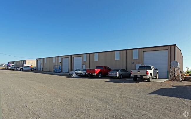

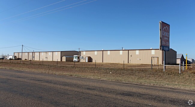
Property Detail
11560 S Coulter St
R-370-0360-3000-0
SECT 36 B S & F BLK 0009, 400 FT E X 830 FT N BEG 1320.06FT N & 50FT W OF SE COR OF SECT, 7.6200 ACRES
Autorepair
RANDALL
A Areas with a 1% annual chance of flooding and a 26% chance of flooding over the life of a 30-year mortgage.
Texas
2024
7.62 AC
2025
Other Market Areas
021707
Amarillo, TX
44,504 SF
NEARBY LISTINGS FOR SALE OR LEASE
DEMOGRAPHICS near 11560 S Coulter St
1 mile
3 mile
5 mile
2024 Total Population
287
17,696
60,354
2029 Population
308
18,784
63,977
Pop Growth 2024-2029
+ 7.32%
+ 6.15%
+ 6.00%
Average Age
38
40
39
2024 Total Households
113
6,679
23,762
HH Growth 2024-2029
+ 7.08%
+ 5.97%
+ 5.84%
Median Household Inc
$86,931
$87,784
$90,725
Avg Household Size
2.50
2.60
2.50
2024 Avg HH Vehicles
2.00
2.00
2.00
Median Home Value
$399,999
$280,981
$272,288
Median Year Built
2009
2002
2000
Nearby Places
Map Layers
Map Styles
 Street
 Aerial
Transit
 Traffic
 Biking
Places
Listings with unknown addresses are not visible on the map
- Restaurants
- Banks
- Shops
- Fitness
- Groceries
Nearby Properties
Address
Land Use
TOTAL SIZE
Lot Size
Zoning
Address
Land Use
TOTAL SIZE
Lot Size
Zoning
362,796 SF
49.98 AC
A
Address
Land Use
TOTAL SIZE
Lot Size
Zoning
258,757 SF
22.78 AC
A
Address
Land Use
TOTAL SIZE
Lot Size
Zoning
148,486 SF
20.66 AC
Address
Land Use
TOTAL SIZE
Lot Size
Zoning
88,841 SF
10.97 AC
R3
Address
Land Use
TOTAL SIZE
Lot Size
Zoning
251,520 SF
9.84 AC
GR
Address
Land Use
TOTAL SIZE
Lot Size
Zoning
190,074 SF
12.07 AC
Address
Land Use
TOTAL SIZE
Lot Size
Zoning
161,321 SF
31 AC
A
Address
Land Use
TOTAL SIZE
Lot Size
Zoning
119,618 SF
11.70 AC
R2
Address
Land Use
TOTAL SIZE
Lot Size
Zoning
161,221 SF
11.78 AC
MF1
Address
Land Use
TOTAL SIZE
Lot Size
Zoning
84,200 SF
7.99 AC
Address
Land Use
TOTAL SIZE
Lot Size
Zoning
42,306 SF
8 AC
Address
Land Use
TOTAL SIZE
Lot Size
Zoning
70,253 SF
8.78 AC
A
Address
Land Use
TOTAL SIZE
Lot Size
Zoning
243,210 SF
20.11 AC
Address
Land Use
TOTAL SIZE
Lot Size
Zoning
60,620 SF
16.33 AC
LC
Address
Land Use
TOTAL SIZE
Lot Size
Zoning
59,625 SF
12 AC
Address
Land Use
TOTAL SIZE
Lot Size
Zoning
266,593 SF
26.42 AC
Address
Land Use
TOTAL SIZE
Lot Size
Zoning
58,937 SF
9.99 AC
R2
Address
Land Use
TOTAL SIZE
Lot Size
Zoning
74,809 SF
12.56 AC
LC
Address
Land Use
TOTAL SIZE
Lot Size
Zoning
57,451 SF
7.55 AC
R2
Address
Land Use
TOTAL SIZE
Lot Size
Zoning
39,284 SF
7.12 AC
MD1
Address
Land Use
TOTAL SIZE
Lot Size
Zoning
42,690 SF
4.91 AC
Address
Land Use
TOTAL SIZE
Lot Size
Zoning
23,451 SF
4.80 AC
A
Address
Land Use
TOTAL SIZE
Lot Size
Zoning
92,348 SF
4.40 AC
Address
Land Use
TOTAL SIZE
Lot Size
Zoning
138,151 SF
7 AC
Address
Land Use
TOTAL SIZE
Lot Size
Zoning
18,112 SF
7.98 AC
Address
Land Use
TOTAL SIZE
Lot Size
Zoning
49,025 SF
4.37 AC
Address
Land Use
TOTAL SIZE
Lot Size
Zoning
42,349 SF
1.72 AC
LC
Address
Land Use
TOTAL SIZE
Lot Size
Zoning
42,597 SF
1.94 AC
LC
Address
Land Use
TOTAL SIZE
Lot Size
Zoning
73,025 SF
5.36 AC
HC
Address
Land Use
TOTAL SIZE
Lot Size
Zoning
44,591 SF
4.24 AC
The World's #1 Commercial Real Estate Marketplace
Connect with us
© 2026 CoStar Group
The information above has been obtained from sources believed reliable. While we do not doubt its accuracy we have not verified it and make no guarantee, warranty or representation about it. It is your responsibility to independently confirm its accuracy and completeness. Any projections, opinions, assumptions, or estimates used are for example only and do not represent the current or future performance of the property. The value of this transaction to you depends on tax and other factors which should be evaluated by your tax, financial, and legal advisors. You and your advisors should conduct a careful, independent investigation of the property to determine to your satisfaction the suitability of the property for your needs.