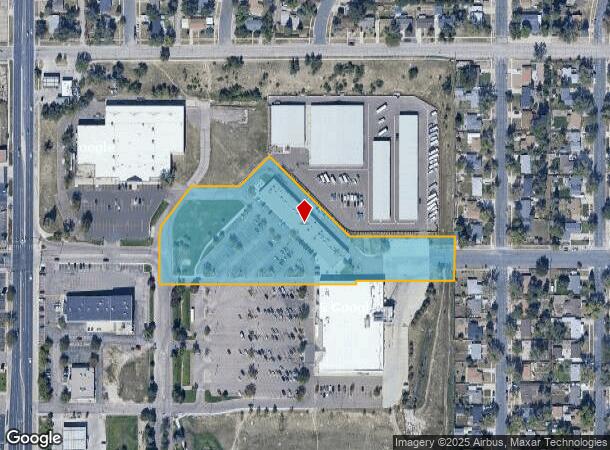
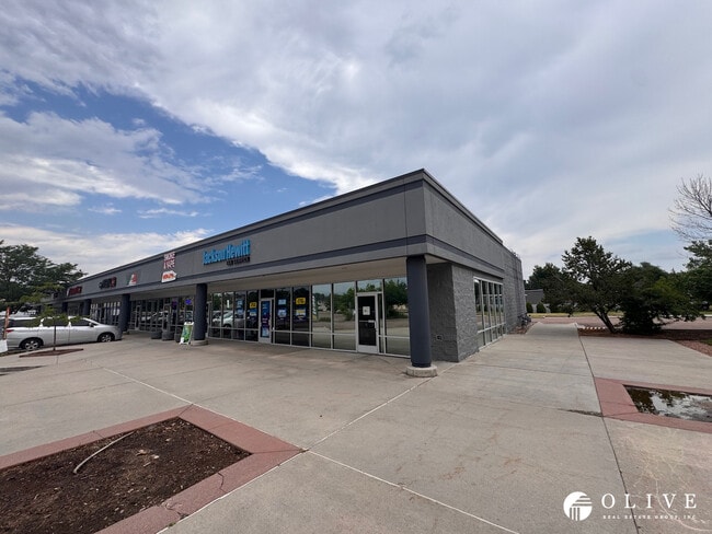
Property Record
1157 N Circle Dr, Colorado Springs, CO 80909


Current Lease Availabilities
NEARBY LISTINGS FOR SALE OR LEASE
Property Detail
1157 N Circle Dr
Colorado Springs, CO
Safeway Marketplace Fil No 2
64102-13-039
LOT 2 SAFEWAY MARKETPLACE FIL NO 2 AS AMENDED BY PROPERTY BOUNDARY ADJ REC MAY 7, 2003 REC #203099197
Commercialbuilding
El Paso
X
Colorado
08041C0732G
2
2024
4.74 AC
2025
East
002000
Colorado Springs
19,200 SF
DEMOGRAPHICS near 1157 N Circle Dr
1 Mile
3 Mile
5 Mile
2024 Total Population
15,849
127,213
291,468
2029 Population
16,475
133,092
304,376
Pop Growth 2024-2029
+ 3.95%
+ 4.62%
+ 4.43%
Average Age
40
38
38
2024 Total Households
7,028
54,203
120,601
HH Growth 2024-2029
+ 4.18%
+ 4.88%
+ 4.69%
Median Household Inc
$47,487
$55,904
$61,488
Avg Household Size
2.20
2.20
2.30
2024 Avg HH Vehicles
2.00
2.00
2.00
Median Home Value
$289,542
$328,041
$336,686
Median Year Built
1966
1971
1977
Nearby Places
Map Layers
Map Styles
 Street
 Aerial
- Restaurants
- Banks
- Shops
- Fitness
- Groceries
PUBLIC TRANSPORTATION
AIRPORT
City of Colorado Springs Municipal
DRIVE
WALK
Distance
City of Colorado Springs Municipal
15 min
6.7 mi
Nearby Properties
Address
Land Use
TOTAL SIZE
Lot Size
Zoning
Address
Land Use
TOTAL SIZE
Lot Size
Zoning
1,072,186 SF
15.14 AC
MX-N HR CU
Address
Land Use
TOTAL SIZE
Lot Size
Zoning
586,419 SF
17.77 AC
R-5 CU
Address
Land Use
TOTAL SIZE
Lot Size
Zoning
604,992 SF
28.95 AC
MX-T CU
Address
Land Use
TOTAL SIZE
Lot Size
Zoning
326,035 SF
33.75 AC
PCR UV
Address
Land Use
TOTAL SIZE
Lot Size
Zoning
229,081 SF
9.87 AC
MX-N CU SS
Address
Land Use
TOTAL SIZE
Lot Size
Zoning
271,048 SF
3.67 AC
FBZ-T2A
Address
Land Use
TOTAL SIZE
Lot Size
Zoning
200,642 SF
6.65 AC
MX-M HR AO
Address
Land Use
TOTAL SIZE
Lot Size
Zoning
167,120 SF
10.59 AC
MX-L/CR CU
Address
Land Use
TOTAL SIZE
Lot Size
Zoning
197,578 SF
7.98 AC
PDZ
Address
Land Use
TOTAL SIZE
Lot Size
Zoning
168,835 SF
33 AC
PF SS
Address
Land Use
TOTAL SIZE
Lot Size
Zoning
75,831 SF
3.37 AC
R-5 P
Address
Land Use
TOTAL SIZE
Lot Size
Zoning
131,545 SF
12.46 AC
R-5/CR CU
Address
Land Use
TOTAL SIZE
Lot Size
Zoning
130,451 SF
0.66 AC
FBZ-CEN
Address
Land Use
TOTAL SIZE
Lot Size
Zoning
138,773 SF
4.45 AC
R-5
Address
Land Use
TOTAL SIZE
Lot Size
Zoning
109,739 SF
18.61 AC
BP/CR CU
Address
Land Use
TOTAL SIZE
Lot Size
Zoning
420,063 SF
2.31 AC
FBZ-CEN
Address
Land Use
TOTAL SIZE
Lot Size
Zoning
70,985 SF
0.65 AC
FBZ-CEN
Address
Land Use
TOTAL SIZE
Lot Size
Zoning
113,594 SF
1.65 AC
R-5 HR
Address
Land Use
TOTAL SIZE
Lot Size
Zoning
184,595 SF
3.67 AC
R-1 6
Address
Land Use
TOTAL SIZE
Lot Size
Zoning
1,223 SF
725.94 AC
PF PK SS
Address
Land Use
TOTAL SIZE
Lot Size
Zoning
53,652 SF
0.52 AC
FBZ-T2A
Address
Land Use
TOTAL SIZE
Lot Size
Zoning
74,258 SF
4.60 AC
MX-T CU
Address
Land Use
TOTAL SIZE
Lot Size
Zoning
33,830 SF
1.09 AC
FBZ-T2A
Address
Land Use
TOTAL SIZE
Lot Size
Zoning
65,400 SF
13.65 AC
PF CU
Address
Land Use
TOTAL SIZE
Lot Size
Zoning
98,638 SF
7.22 AC
MX-M AO
Address
Land Use
TOTAL SIZE
Lot Size
Zoning
125,685 SF
1.28 AC
FBZ-T1
Address
Land Use
TOTAL SIZE
Lot Size
Zoning
75,958 SF
0.96 AC
PK R-5 HR
Address
Land Use
TOTAL SIZE
Lot Size
Zoning
58,105 SF
3.67 AC
PK
Address
Land Use
TOTAL SIZE
Lot Size
Zoning
152,517 SF
12.17 AC
MX-L
Address
Land Use
TOTAL SIZE
Lot Size
Zoning
23,535 SF
15.91 AC
BP/CR AO
The World's #1 Commercial Real Estate Marketplace
Connect with us
© 2025 CoStar Group
The information above has been obtained from sources believed reliable. While we do not doubt its accuracy we have not verified it and make no guarantee, warranty or representation about it. It is your responsibility to independently confirm its accuracy and completeness. Any projections, opinions, assumptions, or estimates used are for example only and do not represent the current or future performance of the property. The value of this transaction to you depends on tax and other factors which should be evaluated by your tax, financial, and legal advisors. You and your advisors should conduct a careful, independent investigation of the property to determine to your satisfaction the suitability of the property for your needs.