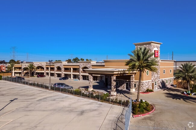
Property Record
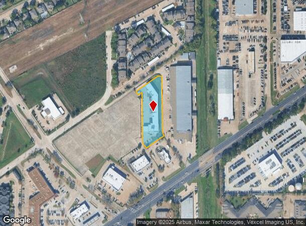
11570 Fm 1960 Rd W, Houston, TX 77065
NEARBY LISTINGS FOR SALE OR LEASE
-
-
View all Houston listings for sale on LoopNet.com
Property Detail
11570 Fm 1960 Rd W
1153800000023
Hastings Green Sec 5
Hotel
RES G7 HASTINGS GREEN SEC 5
X
Harris
48201C0440N
Texas
2024
1.34 AC
2025
Houston Northwest
552401
Houston
24,796 SF
Houston-The Woodlands-Sugar Land, TX
DEMOGRAPHICS near 11570 Fm 1960 Rd W
1 Mile
3 Mile
5 Mile
2024 Total Population
13,360
113,106
255,740
2029 Population
13,423
114,436
258,721
Pop Growth 2024-2029
+ 0.47%
+ 1.18%
+ 1.17%
Average Age
39
37
38
2024 Total Households
4,848
41,671
92,751
HH Growth 2024-2029
+ 0.37%
+ 1.11%
+ 1.12%
Median Household Inc
$62,538
$69,324
$76,691
Avg Household Size
2.60
2.70
2.70
2024 Avg HH Vehicles
2.00
2.00
2.00
Median Home Value
$231,103
$224,128
$244,920
Median Year Built
1994
1992
1993
Nearby Places
- Restaurants
- Banks
- Shops
- Fitness
- Groceries
PUBLIC TRANSPORTATION
AIRPORT
George Bush Intcntl/Houston
DRIVE
WALK
Distance
George Bush Intcntl/Houston
27 min
19.5 mi
William P Hobby
DRIVE
WALK
Distance
William P Hobby
53 min
34.8 mi
Freight Ports
Port of Houston
DRIVE
WALK
Distance
Port of Houston
44 min
30.5 mi
SALE & LEASE HISTORY
LISTING DATE
SALE/LEASE

Jun 23, 2022
For Sale
Nearby Properties
Address
Land Use
TOTAL SIZE
Lot Size
Zoning
Address
Land Use
TOTAL SIZE
Lot Size
Zoning
311,285 SF
14.47 AC
Address
Land Use
TOTAL SIZE
Lot Size
Zoning
660,000 SF
104.88 AC
Address
Land Use
TOTAL SIZE
Lot Size
Zoning
682,700 SF
37 AC
Address
Land Use
TOTAL SIZE
Lot Size
Zoning
625,701 SF
52.20 AC
Address
Land Use
TOTAL SIZE
Lot Size
Zoning
697,158 SF
Address
Land Use
TOTAL SIZE
Lot Size
Zoning
664,361 SF
39.18 AC
Address
Land Use
TOTAL SIZE
Lot Size
Zoning
466,299 SF
23.82 AC
Address
Land Use
TOTAL SIZE
Lot Size
Zoning
560,725 SF
31.41 AC
Address
Land Use
TOTAL SIZE
Lot Size
Zoning
373,516 SF
18.63 AC
Address
Land Use
TOTAL SIZE
Lot Size
Zoning
266,802 SF
3.14 AC
Address
Land Use
TOTAL SIZE
Lot Size
Zoning
408,710 SF
4.49 AC
Address
Land Use
TOTAL SIZE
Lot Size
Zoning
426,203 SF
23.88 AC
Address
Land Use
TOTAL SIZE
Lot Size
Zoning
301,119 SF
9.92 AC
Address
Land Use
TOTAL SIZE
Lot Size
Zoning
471,800 SF
27.03 AC
Address
Land Use
TOTAL SIZE
Lot Size
Zoning
307,698 SF
13.12 AC
Address
Land Use
TOTAL SIZE
Lot Size
Zoning
449,032 SF
23.46 AC
Address
Land Use
TOTAL SIZE
Lot Size
Zoning
387,245 SF
18.18 AC
Address
Land Use
TOTAL SIZE
Lot Size
Zoning
151,314 SF
3.88 AC
Address
Land Use
TOTAL SIZE
Lot Size
Zoning
402,712 SF
25.64 AC
Address
Land Use
TOTAL SIZE
Lot Size
Zoning
375,251 SF
14.85 AC
Address
Land Use
TOTAL SIZE
Lot Size
Zoning
401,107 SF
33.90 AC
Address
Land Use
TOTAL SIZE
Lot Size
Zoning
463,932 SF
26.62 AC
Address
Land Use
TOTAL SIZE
Lot Size
Zoning
384,280 SF
27.19 AC
Address
Land Use
TOTAL SIZE
Lot Size
Zoning
461,430 SF
22.46 AC
Address
Land Use
TOTAL SIZE
Lot Size
Zoning
275,561 SF
19.78 AC
Address
Land Use
TOTAL SIZE
Lot Size
Zoning
371,729 SF
18.73 AC
Address
Land Use
TOTAL SIZE
Lot Size
Zoning
237,742 SF
13.80 AC
Address
Land Use
TOTAL SIZE
Lot Size
Zoning
364,057 SF
22.03 AC
Address
Land Use
TOTAL SIZE
Lot Size
Zoning
221,214 SF
8.33 AC
Address
Land Use
TOTAL SIZE
Lot Size
Zoning
320,985 SF
14.88 AC
The World's #1 Commercial Real Estate Marketplace
Connect with us
© 2025 CoStar Group
The information above has been obtained from sources believed reliable. While we do not doubt its accuracy we have not verified it and make no guarantee, warranty or representation about it. It is your responsibility to independently confirm its accuracy and completeness. Any projections, opinions, assumptions, or estimates used are for example only and do not represent the current or future performance of the property. The value of this transaction to you depends on tax and other factors which should be evaluated by your tax, financial, and legal advisors. You and your advisors should conduct a careful, independent investigation of the property to determine to your satisfaction the suitability of the property for your needs.