Property Record
11571 Clark Rd, Davisburg, MI 48350

NEARBY LISTINGS FOR SALE OR LEASE
-
-
View all Davisburg listings for sale on LoopNet.com
Property Detail
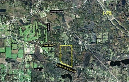
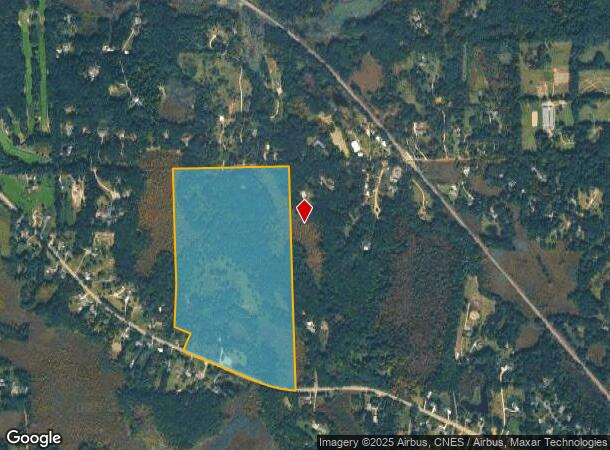
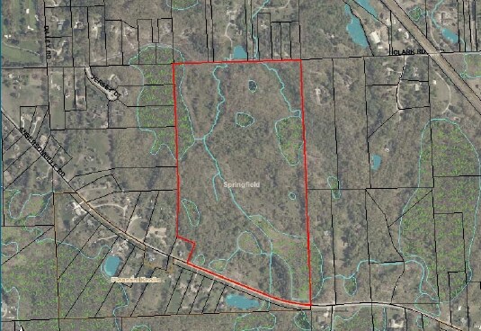
11571 Clark Rd
07-21-101-008
T4N, R8E, SEC 21 PART OF NW 1/4 BEG AT N 1/4 COR, TH S 00-50-37 W 2579 FT, TH ALG CURVE CONCAVE NLY, RAD 1432.11 FT, CHORD
Residentialacreage
Oakland
X
Michigan
26125C0310F
71.62 AC
0
St Clair & Lapeer Counties
2024
Detroit
126400
Detroit-Warren-Dearborn, MI
DEMOGRAPHICS near 11571 Clark Rd
1 Mile
3 Mile
5 Mile
2024 Total Population
1,243
9,899
30,206
2029 Population
1,240
9,809
30,002
Pop Growth 2024-2029
(0.24%)
(0.91%)
(0.68%)
Average Age
43
43
43
2024 Total Households
449
3,679
11,251
HH Growth 2024-2029
(0.22%)
(0.98%)
(0.71%)
Median Household Inc
$102,254
$103,918
$102,121
Avg Household Size
2.70
2.70
2.60
2024 Avg HH Vehicles
2.00
2.00
2.00
Median Home Value
$340,178
$347,931
$333,254
Median Year Built
1988
1987
1987
Nearby Places
Map Layers
Map Styles
 Street
 Aerial
- Restaurants
- Banks
- Shops
- Fitness
- Groceries
PUBLIC TRANSPORTATION
AIRPORT
Bishop International
DRIVE
WALK
Distance
Bishop International
47 min
27.5 mi
Freight Ports
Port of Toledo
DRIVE
WALK
Distance
Port of Toledo
117 min
88.8 mi
Nearby Properties
Address
Land Use
TOTAL SIZE
Lot Size
Zoning
Address
Land Use
TOTAL SIZE
Lot Size
Zoning
34,111 SF
20.14 AC
Address
Land Use
TOTAL SIZE
Lot Size
Zoning
6,981 SF
88.04 AC
Address
Land Use
TOTAL SIZE
Lot Size
Zoning
261,633 SF
1,321.20 AC
C2GEN
Address
Land Use
TOTAL SIZE
Lot Size
Zoning
26,221 SF
15.76 AC
C2
Address
Land Use
TOTAL SIZE
Lot Size
Zoning
44,258 SF
8.86 AC
C2GEN
Address
Land Use
TOTAL SIZE
Lot Size
Zoning
59,491 SF
6.94 AC
C2GEN
Address
Land Use
TOTAL SIZE
Lot Size
Zoning
26,331 SF
6 AC
C2GEN
Address
Land Use
TOTAL SIZE
Lot Size
Zoning
74,592 SF
8.05 AC
RMMULT
Address
Land Use
TOTAL SIZE
Lot Size
Zoning
57,600 SF
15.72 AC
M1LITE
Address
Land Use
TOTAL SIZE
Lot Size
Zoning
77,403 SF
4.58 AC
M1LITE
Address
Land Use
TOTAL SIZE
Lot Size
Zoning
14,218 SF
16.94 AC
Address
Land Use
TOTAL SIZE
Lot Size
Zoning
64,195 SF
5.01 AC
M1LITE
Address
Land Use
TOTAL SIZE
Lot Size
Zoning
20,135 SF
4.54 AC
C2
Address
Land Use
TOTAL SIZE
Lot Size
Zoning
13,667 SF
2.33 AC
R1
Address
Land Use
TOTAL SIZE
Lot Size
Zoning
19.27 AC
C2
Address
Land Use
TOTAL SIZE
Lot Size
Zoning
4,068 SF
1.44 AC
C2
Address
Land Use
TOTAL SIZE
Lot Size
Zoning
31,378 SF
2.42 AC
M1LITE
Address
Land Use
TOTAL SIZE
Lot Size
Zoning
18,791 SF
30 AC
OSOFF
Address
Land Use
TOTAL SIZE
Lot Size
Zoning
6,268 SF
4.33 AC
OS
Address
Land Use
TOTAL SIZE
Lot Size
Zoning
26,701 SF
2.78 AC
M1LITE
Address
Land Use
TOTAL SIZE
Lot Size
Zoning
25,060 SF
3.85 AC
RMMULT
Address
Land Use
TOTAL SIZE
Lot Size
Zoning
8,534 SF
3 AC
C2GEN
Address
Land Use
TOTAL SIZE
Lot Size
Zoning
19,080 SF
40.01 AC
M1LITE
Address
Land Use
TOTAL SIZE
Lot Size
Zoning
4,428 SF
1.66 AC
PUD
Address
Land Use
TOTAL SIZE
Lot Size
Zoning
35,810 SF
2.01 AC
M1
Address
Land Use
TOTAL SIZE
Lot Size
Zoning
15,475 SF
3.50 AC
M1LITE
Address
Land Use
TOTAL SIZE
Lot Size
Zoning
3,996 SF
1.74 AC
C2GEN
Address
Land Use
TOTAL SIZE
Lot Size
Zoning
32,640 SF
2.67 AC
M1LITE
Address
Land Use
TOTAL SIZE
Lot Size
Zoning
20,955 SF
169.94 AC
RCRCON
Address
Land Use
TOTAL SIZE
Lot Size
Zoning
20,011 SF
2.30 AC
M1LITE
The World's #1 Commercial Real Estate Marketplace
Connect with us
© 2025 CoStar Group
The information above has been obtained from sources believed reliable. While we do not doubt its accuracy we have not verified it and make no guarantee, warranty or representation about it. It is your responsibility to independently confirm its accuracy and completeness. Any projections, opinions, assumptions, or estimates used are for example only and do not represent the current or future performance of the property. The value of this transaction to you depends on tax and other factors which should be evaluated by your tax, financial, and legal advisors. You and your advisors should conduct a careful, independent investigation of the property to determine to your satisfaction the suitability of the property for your needs.