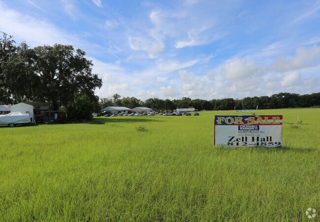
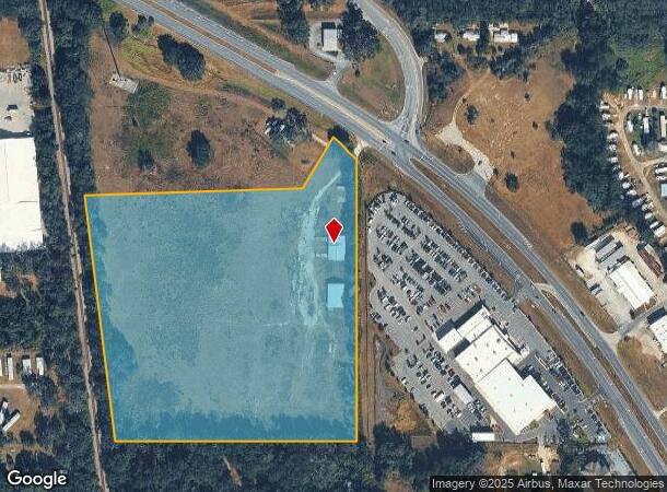
Property Record
11580 Se Us Highway 441, Belleview, FL 34420

NEARBY LISTINGS FOR SALE OR LEASE
Property Detail
11580 Se Us Highway 441
39158-000-00
SEC 31 TWP 16 RGE 23 A PORTION OF NW 1/4 OF SE 1/4 MORE PART DESC AS: COM AT THE INTERSECTION OF THE ELY ROW LINE OF THE SEABOARD RR (CSX RR) WITH THE N LINE OF THE NW 1/4 OF THE SE 1/4 OF SEC 31 TH S 09-12-51 E ALONG SAID ELY ROW LINE 554.51 FT TO T
Vacantlandnec
Marion
X
Florida
12083C0741D
15.04 AC
2024
Outlying Marion County
2024
Ocala
000803
Ocala, FL
7,350 SF
DEMOGRAPHICS near 11580 Se Us Highway 441
1 Mile
3 Mile
5 Mile
2024 Total Population
4,715
23,373
64,393
2029 Population
5,328
26,497
73,420
Pop Growth 2024-2029
+ 13.00%
+ 13.37%
+ 14.02%
Average Age
41
45
43
2024 Total Households
1,853
9,773
26,046
HH Growth 2024-2029
+ 12.95%
+ 13.20%
+ 13.95%
Median Household Inc
$43,352
$54,167
$55,862
Avg Household Size
2.50
2.40
2.40
2024 Avg HH Vehicles
2.00
2.00
2.00
Median Home Value
$142,829
$194,420
$173,929
Median Year Built
1985
1996
1994
Nearby Places
Map Layers
Map Styles
 Street
 Aerial
- Restaurants
- Banks
- Shops
- Fitness
- Groceries
SALE & LEASE HISTORY
LISTING DATE
SALE/LEASE

Jul 17, 2017
For Sale
Nearby Properties
Address
Land Use
TOTAL SIZE
Lot Size
Zoning
Address
Land Use
TOTAL SIZE
Lot Size
Zoning
11,692 SF
503.98 AC
GU
Address
Land Use
TOTAL SIZE
Lot Size
Zoning
1,800 SF
954.07 AC
A1
Address
Land Use
TOTAL SIZE
Lot Size
Zoning
78,133 SF
20.10 AC
GU
Address
Land Use
TOTAL SIZE
Lot Size
Zoning
76,351 SF
14.60 AC
GU
Address
Land Use
TOTAL SIZE
Lot Size
Zoning
54,297 SF
6.32 AC
B2
Address
Land Use
TOTAL SIZE
Lot Size
Zoning
52,400 SF
6.50 AC
R3
Address
Land Use
TOTAL SIZE
Lot Size
Zoning
97,449 SF
13.29 AC
B2
Address
Land Use
TOTAL SIZE
Lot Size
Zoning
28,457 SF
3.30 AC
B4
Address
Land Use
TOTAL SIZE
Lot Size
Zoning
13,969 SF
72.48 AC
B2
Address
Land Use
TOTAL SIZE
Lot Size
Zoning
30,862 SF
8.09 AC
B2
Address
Land Use
TOTAL SIZE
Lot Size
Zoning
22,960 SF
3.09 AC
B4
Address
Land Use
TOTAL SIZE
Lot Size
Zoning
43,281 SF
21.36 AC
B2
Address
Land Use
TOTAL SIZE
Lot Size
Zoning
66,190 SF
6.41 AC
B5
Address
Land Use
TOTAL SIZE
Lot Size
Zoning
50,776 SF
12.05 AC
B2
Address
Land Use
TOTAL SIZE
Lot Size
Zoning
13,858 SF
1.83 AC
B4
Address
Land Use
TOTAL SIZE
Lot Size
Zoning
18,213 SF
6.88 AC
GU
Address
Land Use
TOTAL SIZE
Lot Size
Zoning
43,882 SF
3.93 AC
B4
Address
Land Use
TOTAL SIZE
Lot Size
Zoning
40,000 SF
4.06 AC
M1
Address
Land Use
TOTAL SIZE
Lot Size
Zoning
67,198 SF
9 AC
B5
Address
Land Use
TOTAL SIZE
Lot Size
Zoning
13,920 SF
2.09 AC
B2
Address
Land Use
TOTAL SIZE
Lot Size
Zoning
13,347 SF
5.21 AC
GU
Address
Land Use
TOTAL SIZE
Lot Size
Zoning
51,694 SF
3.80 AC
B5
Address
Land Use
TOTAL SIZE
Lot Size
Zoning
24,816 SF
3.34 AC
R3
Address
Land Use
TOTAL SIZE
Lot Size
Zoning
43,924 SF
3.20 AC
B5
Address
Land Use
TOTAL SIZE
Lot Size
Zoning
16,129 SF
5 AC
GU
Address
Land Use
TOTAL SIZE
Lot Size
Zoning
23,065 SF
2.77 AC
R3
Address
Land Use
TOTAL SIZE
Lot Size
Zoning
38,398 SF
9.88 AC
R1
Address
Land Use
TOTAL SIZE
Lot Size
Zoning
21,062 SF
6.75 AC
A1
Address
Land Use
TOTAL SIZE
Lot Size
Zoning
16,944 SF
26 AC
A1
Address
Land Use
TOTAL SIZE
Lot Size
Zoning
14,996 SF
2.42 AC
B4
The World's #1 Commercial Real Estate Marketplace
Connect with us
© 2025 CoStar Group
The information above has been obtained from sources believed reliable. While we do not doubt its accuracy we have not verified it and make no guarantee, warranty or representation about it. It is your responsibility to independently confirm its accuracy and completeness. Any projections, opinions, assumptions, or estimates used are for example only and do not represent the current or future performance of the property. The value of this transaction to you depends on tax and other factors which should be evaluated by your tax, financial, and legal advisors. You and your advisors should conduct a careful, independent investigation of the property to determine to your satisfaction the suitability of the property for your needs.