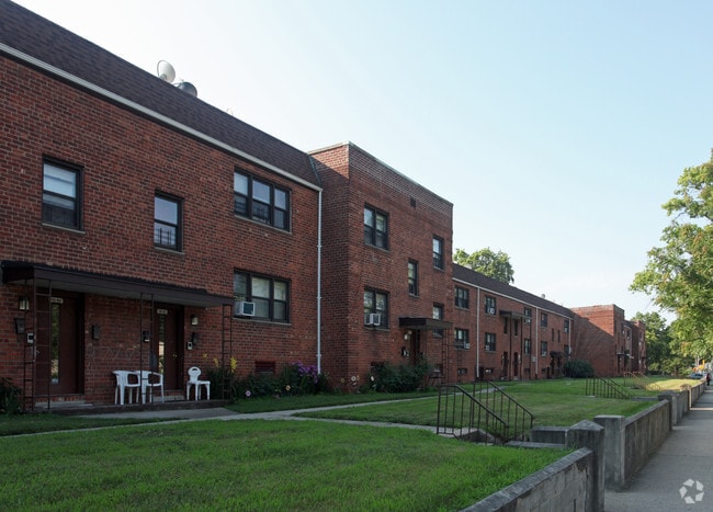
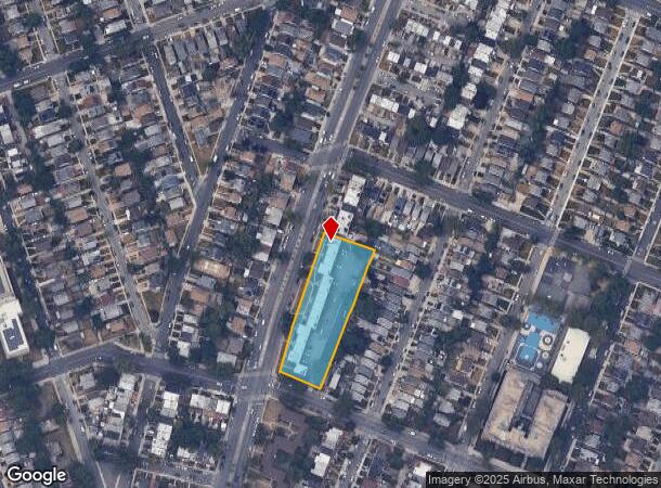
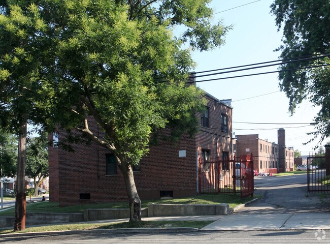
Property Record
11585 Springfield Blvd, Cambria Heights, NY 11411
NEARBY LISTINGS FOR SALE OR LEASE
-
-
-
No Photo
-
-
-
-
-
-
View all Cambria Heights listings for sale on LoopNet.com
Property Detail
11585 Springfield Blvd
11298-0008
Queens
Apartment
New York
X
8
36059C0205G
1.25 AC
2024
Cambria Heights
2025
Long Island (New York)
059800
New York-Jersey City-White Plains, NY-NJ
23,420 SF
DEMOGRAPHICS near 11585 Springfield Blvd
1 Mile
3 Mile
5 Mile
2024 Total Population
52,969
434,715
1,038,146
2029 Population
48,702
405,114
974,748
Pop Growth 2024-2029
(8.06%)
(6.81%)
(6.11%)
Average Age
43
42
42
2024 Total Households
15,984
134,965
334,097
HH Growth 2024-2029
(8.63%)
(7.16%)
(6.36%)
Median Household Inc
$96,257
$85,934
$89,810
Avg Household Size
3.20
3.10
3.00
2024 Avg HH Vehicles
1.00
1.00
1.00
Median Home Value
$595,400
$625,955
$667,178
Median Year Built
1947
1951
1952
Nearby Places
- Restaurants
- Banks
- Shops
- Fitness
- Groceries
PUBLIC TRANSPORTATION
COMMUTER RAIL
Queens Village Station (Hempstead Branch - Long Island Rail Road)
DRIVE
WALK
Distance
Queens Village Station (Hempstead Branch - Long Island Rail Road)
4 min
1.7 mi
Saint Albans Station (West Hempstead Branch - Long Island Rail Road)
DRIVE
WALK
Distance
Saint Albans Station (West Hempstead Branch - Long Island Rail Road)
6 min
1.8 mi
AIRPORT
John F Kennedy International
DRIVE
WALK
Distance
John F Kennedy International
13 min
6.4 mi
LaGuardia
DRIVE
WALK
Distance
LaGuardia
20 min
11.7 mi
Newark Liberty International
DRIVE
WALK
Distance
Newark Liberty International
46 min
31.0 mi
Freight Ports
NY - Red Hook Container Terminal
DRIVE
WALK
Distance
NY - Red Hook Container Terminal
31 min
19.8 mi
Nearby Properties
Address
Land Use
TOTAL SIZE
Lot Size
Zoning
Address
Land Use
TOTAL SIZE
Lot Size
Zoning
986,724 SF
89.79 AC
R3-2
Address
Land Use
TOTAL SIZE
Lot Size
Zoning
800 SF
104.61 AC
PARK
Address
Land Use
TOTAL SIZE
Lot Size
Zoning
294.47 AC
PARK
Address
Land Use
TOTAL SIZE
Lot Size
Zoning
13,500 SF
104 AC
PARK
Address
Land Use
TOTAL SIZE
Lot Size
Zoning
731,247 SF
56.09 AC
R3-2
Address
Land Use
TOTAL SIZE
Lot Size
Zoning
448,500 SF
22.59 AC
R3-2
Address
Land Use
TOTAL SIZE
Lot Size
Zoning
636,219 SF
11.39 AC
R3-2
Address
Land Use
TOTAL SIZE
Lot Size
Zoning
82.92 AC
PARK
Address
Land Use
TOTAL SIZE
Lot Size
Zoning
900 SF
86.35 AC
PARK
Address
Land Use
TOTAL SIZE
Lot Size
Zoning
478,384 SF
1.23 AC
C6-3
Address
Land Use
TOTAL SIZE
Lot Size
Zoning
360,000 SF
8.78 AC
R6
Address
Land Use
TOTAL SIZE
Lot Size
Zoning
569,583 SF
2.28 AC
C4-5X
Address
Land Use
TOTAL SIZE
Lot Size
Zoning
1,400 SF
42.67 AC
PARK
Address
Land Use
TOTAL SIZE
Lot Size
Zoning
295,904 SF
0.63 AC
C6-3
Address
Land Use
TOTAL SIZE
Lot Size
Zoning
7,030 SF
12.43 AC
R3-2
Address
Land Use
TOTAL SIZE
Lot Size
Zoning
285,170 SF
12.63 AC
R3-1
Address
Land Use
TOTAL SIZE
Lot Size
Zoning
471,648 SF
1.46 AC
C6-3
Address
Land Use
TOTAL SIZE
Lot Size
Zoning
50,000 SF
52.45 AC
PARK
Address
Land Use
TOTAL SIZE
Lot Size
Zoning
175,040 SF
10.19 AC
R3X
Address
Land Use
TOTAL SIZE
Lot Size
Zoning
199,864 SF
1.76 AC
C4-5X
Address
Land Use
TOTAL SIZE
Lot Size
Zoning
129,378 SF
4.86 AC
R2A
Address
Land Use
TOTAL SIZE
Lot Size
Zoning
187,000 SF
3.24 AC
R4-1
Address
Land Use
TOTAL SIZE
Lot Size
Zoning
304,128 SF
3.70 AC
R6
Address
Land Use
TOTAL SIZE
Lot Size
Zoning
260,000 SF
3.10 AC
M1-4
Address
Land Use
TOTAL SIZE
Lot Size
Zoning
41,756 SF
1.02 AC
R5D
Address
Land Use
TOTAL SIZE
Lot Size
Zoning
160,000 SF
4.02 AC
R3-2
Address
Land Use
TOTAL SIZE
Lot Size
Zoning
189,693 SF
2.11 AC
R3-2
Address
Land Use
TOTAL SIZE
Lot Size
Zoning
165,600 SF
2.11 AC
R6
Address
Land Use
TOTAL SIZE
Lot Size
Zoning
99,814 SF
1.31 AC
R3-2
Address
Land Use
TOTAL SIZE
Lot Size
Zoning
185,328 SF
2.69 AC
R5
The World's #1 Commercial Real Estate Marketplace
Connect with us
© 2025 CoStar Group
The information above has been obtained from sources believed reliable. While we do not doubt its accuracy we have not verified it and make no guarantee, warranty or representation about it. It is your responsibility to independently confirm its accuracy and completeness. Any projections, opinions, assumptions, or estimates used are for example only and do not represent the current or future performance of the property. The value of this transaction to you depends on tax and other factors which should be evaluated by your tax, financial, and legal advisors. You and your advisors should conduct a careful, independent investigation of the property to determine to your satisfaction the suitability of the property for your needs.