Property Record
116 Braxton Rd, Washington, GA 30673
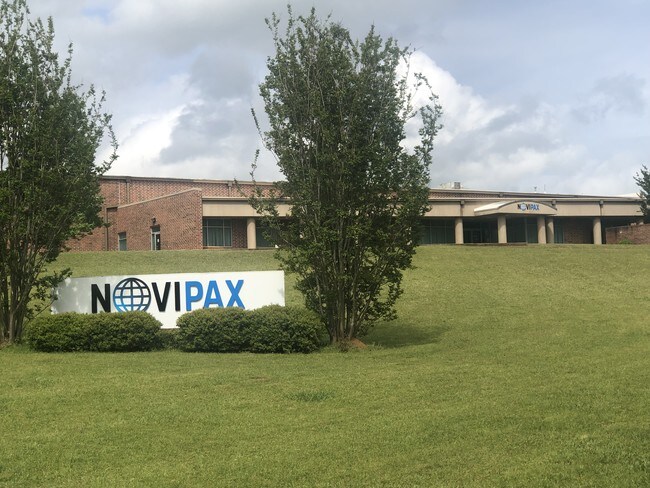
Property Detail
116 Braxton Rd
Industrialgeneral
164 GMD PB 14:192 TRACT A
001
WILKES
B and X Area of moderate flood hazard, usually the area between the limits of the 100-year and 500-year floods.
Georgia
2025
14.81 AC
2025
Georgia Northeast
010302
Other Market Areas
14,976 SF
064-006A
NEARBY LISTINGS FOR SALE OR LEASE
DEMOGRAPHICS near 116 Braxton Rd
1 mile
3 mile
5 mile
2025 Total Population
38
3,161
5,057
2030 Population
38
3,155
5,044
Pop Growth 2025-2030
0.00%
(0.19%)
(0.26%)
Average Age
42
44
44
2025 Total Households
14
1,362
2,165
HH Growth 2025-2030
0.00%
(0.22%)
(0.28%)
Median Household Inc
$22,500
$49,999
$48,042
Avg Household Size
2.40
2.30
2.30
2025 Avg HH Vehicles
1.00
2.00
2.00
Median Home Value
$199,999
$104,913
$113,333
Median Year Built
1980
1975
1975
Nearby Places
Map Layers
Map Styles
 Street
 Aerial
Transit
 Traffic
 Biking
Places
Listings with unknown addresses are not visible on the map
- Restaurants
- Banks
- Shops
- Fitness
- Groceries
SALE & LEASE HISTORY
LISTING DATE
SALE/LEASE

Aug 06, 2019
For Sale
Nearby Properties
Address
Land Use
TOTAL SIZE
Lot Size
Zoning
Address
Land Use
TOTAL SIZE
Lot Size
Zoning
4,288 SF
30.03 AC
002
Address
Land Use
TOTAL SIZE
Lot Size
Zoning
48,894 SF
10.10 AC
002
Address
Land Use
TOTAL SIZE
Lot Size
Zoning
196,212 SF
86.82 AC
003
Address
Land Use
TOTAL SIZE
Lot Size
Zoning
27,552 SF
1.36 AC
001
Address
Land Use
TOTAL SIZE
Lot Size
Zoning
166,772 SF
14.69 AC
003
Address
Land Use
TOTAL SIZE
Lot Size
Zoning
35,236 SF
10.78 AC
002
Address
Land Use
TOTAL SIZE
Lot Size
Zoning
44,693 SF
20.23 AC
001
Address
Land Use
TOTAL SIZE
Lot Size
Zoning
51,863 SF
7.34 AC
001
Address
Land Use
TOTAL SIZE
Lot Size
Zoning
19,702 SF
4 AC
M-2
Address
Land Use
TOTAL SIZE
Lot Size
Zoning
17,285 SF
1.61 AC
001
Address
Land Use
TOTAL SIZE
Lot Size
Zoning
4,472 SF
23.82 AC
001
Address
Land Use
TOTAL SIZE
Lot Size
Zoning
1,344 SF
27.37 AC
001
Address
Land Use
TOTAL SIZE
Lot Size
Zoning
696 SF
20.96 AC
RMH
Address
Land Use
TOTAL SIZE
Lot Size
Zoning
30,196 SF
16.44 AC
001
Address
Land Use
TOTAL SIZE
Lot Size
Zoning
42,831 SF
7.42 AC
002
Address
Land Use
TOTAL SIZE
Lot Size
Zoning
76,645 SF
36.09 AC
003
Address
Land Use
TOTAL SIZE
Lot Size
Zoning
11,624 SF
0.95 AC
001
Address
Land Use
TOTAL SIZE
Lot Size
Zoning
118,010 SF
19.40 AC
003
Address
Land Use
TOTAL SIZE
Lot Size
Zoning
9,300 SF
1.80 AC
002
Address
Land Use
TOTAL SIZE
Lot Size
Zoning
1,242 SF
7 AC
001
Address
Land Use
TOTAL SIZE
Lot Size
Zoning
11,041 SF
0.58 AC
001
Address
Land Use
TOTAL SIZE
Lot Size
Zoning
14,029 SF
1.30 AC
C3
Address
Land Use
TOTAL SIZE
Lot Size
Zoning
15,876 SF
3.71 AC
001
Address
Land Use
TOTAL SIZE
Lot Size
Zoning
161,676 SF
16 AC
001
Address
Land Use
TOTAL SIZE
Lot Size
Zoning
70,692 SF
6.34 AC
001
Address
Land Use
TOTAL SIZE
Lot Size
Zoning
1,690 SF
10.88 AC
001
Address
Land Use
TOTAL SIZE
Lot Size
Zoning
1,560 SF
7.60 AC
001
Address
Land Use
TOTAL SIZE
Lot Size
Zoning
9,020 SF
1.67 AC
001
Address
Land Use
TOTAL SIZE
Lot Size
Zoning
89,980 SF
5.78 AC
001
The World's #1 Commercial Real Estate Marketplace
Connect with us
© 2026 CoStar Group
The information above has been obtained from sources believed reliable. While we do not doubt its accuracy we have not verified it and make no guarantee, warranty or representation about it. It is your responsibility to independently confirm its accuracy and completeness. Any projections, opinions, assumptions, or estimates used are for example only and do not represent the current or future performance of the property. The value of this transaction to you depends on tax and other factors which should be evaluated by your tax, financial, and legal advisors. You and your advisors should conduct a careful, independent investigation of the property to determine to your satisfaction the suitability of the property for your needs.