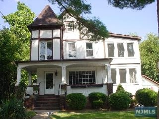
Property Record
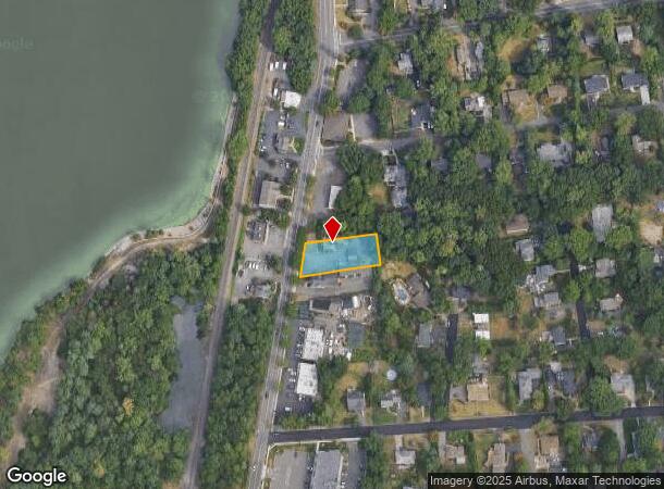
116 Broadway, Norwood, NJ 07648

NEARBY LISTINGS FOR SALE OR LEASE
Property Detail
116 Broadway
68-02703-0000-00023
.394
Commercialnec
Bergen
X
New Jersey
34003C0093H
23
2024
0.39 AC
2025
Upper Parkway
035200
Northern New Jersey
2,476 SF
New York-Jersey City-White Plains, NY-NJ
DEMOGRAPHICS near 116 Broadway
1 mile
3 mile
5 mile
2024 Total Population
8,530
76,406
208,121
2029 Population
8,512
76,423
208,099
Pop Growth 2024-2029
(0.21%)
+ 0.02%
(0.01%)
Average Age
42
43
42
2024 Total Households
3,007
27,394
70,750
HH Growth 2024-2029
(0.17%)
(0.01%)
(0.06%)
Median Household Inc
$159,243
$148,985
$147,932
Avg Household Size
2.80
2.70
2.90
2024 Avg HH Vehicles
2.00
2.00
2.00
Median Home Value
$711,334
$698,367
$708,379
Median Year Built
1961
1963
1961
Nearby Places
Map Layers
Map Styles
 Street
 Aerial
Transit
 Traffic
 Biking
Places
Listings with unknown addresses are not visible on the map
- Restaurants
- Banks
- Shops
- Fitness
- Groceries
PUBLIC TRANSPORTATION
TRANSIT/SUBWAY
Woodcliff Lake (Pascack Valley Line - NJ Transit Commuter Rail (NJ Transit))
Drive
Walk
Distance
Woodcliff Lake (Pascack Valley Line - NJ Transit Commuter Rail (NJ Transit))
1 min
5 min
0.2 mi
COMMUTER RAIL
Woodcliff Lake (Pascack Valley Line - NJ Transit Commuter Rail (NJ Transit))
Drive
Walk
Distance
Woodcliff Lake (Pascack Valley Line - NJ Transit Commuter Rail (NJ Transit))
1 min
5 min
0.2 mi
Hillsdale (Pascack Valley Line - NJ Transit Commuter Rail (NJ Transit))
Drive
Walk
Distance
Hillsdale (Pascack Valley Line - NJ Transit Commuter Rail (NJ Transit))
3 min
1.1 mi
AIRPORT
LaGuardia
Drive
Walk
Distance
LaGuardia
41 min
25.7 mi
Westchester County
Drive
Walk
Distance
Westchester County
42 min
28.3 mi
Newark Liberty International
Drive
Walk
Distance
Newark Liberty International
37 min
28.4 mi
Freight Ports
NY - Red Hook Container Terminal
Drive
Walk
Distance
NY - Red Hook Container Terminal
51 min
29.6 mi
Nearby Properties
Address
Land Use
TOTAL SIZE
Lot Size
Zoning
Address
Land Use
TOTAL SIZE
Lot Size
Zoning
19.96 AC
HSO
Address
Land Use
TOTAL SIZE
Lot Size
Zoning
131,384 SF
65 AC
EO
Address
Land Use
TOTAL SIZE
Lot Size
Zoning
Address
Land Use
TOTAL SIZE
Lot Size
Zoning
205,580 SF
21.18 AC
EO
Address
Land Use
TOTAL SIZE
Lot Size
Zoning
8.78 AC
HSO
Address
Land Use
TOTAL SIZE
Lot Size
Zoning
59 AC
AA
Address
Land Use
TOTAL SIZE
Lot Size
Zoning
Address
Land Use
TOTAL SIZE
Lot Size
Zoning
7.04 AC
SED
Address
Land Use
TOTAL SIZE
Lot Size
Zoning
Address
Land Use
TOTAL SIZE
Lot Size
Zoning
Address
Land Use
TOTAL SIZE
Lot Size
Zoning
13 AC
EAO
Address
Land Use
TOTAL SIZE
Lot Size
Zoning
22.75 AC
Address
Land Use
TOTAL SIZE
Lot Size
Zoning
11.48 AC
OR-3
Address
Land Use
TOTAL SIZE
Lot Size
Zoning
9.29 AC
SED
Address
Land Use
TOTAL SIZE
Lot Size
Zoning
21.74 AC
SC
Address
Land Use
TOTAL SIZE
Lot Size
Zoning
Address
Land Use
TOTAL SIZE
Lot Size
Zoning
36.49 AC
OR-2
Address
Land Use
TOTAL SIZE
Lot Size
Zoning
31.79 AC
OR2
Address
Land Use
TOTAL SIZE
Lot Size
Zoning
Address
Land Use
TOTAL SIZE
Lot Size
Zoning
2,374 SF
1.80 AC
SOII
Address
Land Use
TOTAL SIZE
Lot Size
Zoning
71,166 SF
7.26 AC
B3
Address
Land Use
TOTAL SIZE
Lot Size
Zoning
845.02 AC
Address
Land Use
TOTAL SIZE
Lot Size
Zoning
3.33 AC
R3
Address
Land Use
TOTAL SIZE
Lot Size
Zoning
Address
Land Use
TOTAL SIZE
Lot Size
Zoning
15,065 SF
9.30 AC
RC
Address
Land Use
TOTAL SIZE
Lot Size
Zoning
24.45 AC
R40
Address
Land Use
TOTAL SIZE
Lot Size
Zoning
62,728 SF
14.49 AC
RA15
Address
Land Use
TOTAL SIZE
Lot Size
Zoning
1,295,615 SF
93.54 AC
OP
Address
Land Use
TOTAL SIZE
Lot Size
Zoning
4 AC
HSO
Address
Land Use
TOTAL SIZE
Lot Size
Zoning
10.94 AC
AA
The World's #1 Commercial Real Estate Marketplace
Connect with us
© 2026 CoStar Group
The information above has been obtained from sources believed reliable. While we do not doubt its accuracy we have not verified it and make no guarantee, warranty or representation about it. It is your responsibility to independently confirm its accuracy and completeness. Any projections, opinions, assumptions, or estimates used are for example only and do not represent the current or future performance of the property. The value of this transaction to you depends on tax and other factors which should be evaluated by your tax, financial, and legal advisors. You and your advisors should conduct a careful, independent investigation of the property to determine to your satisfaction the suitability of the property for your needs.