Property Record
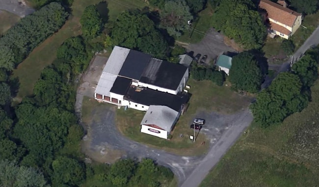
116 Costa Rd, Highland, NY 12528


This Property Is For Sale
NEARBY LISTINGS FOR SALE OR LEASE
Property Detail
116 Costa Rd
3200-087.003-0006-004.100-0000
Subdivision Map For Frank Ligotino
Distributionwarehouseregional
Ulster
X
New York
36111C0760E
4.100
2025
1.24 AC
2024
Newburgh/Kingston
953700
Other Market Areas
4,175 SF
Kingston, NY
DEMOGRAPHICS near 116 Costa Rd
1 Mile
3 Mile
5 Mile
2024 Total Population
673
14,867
30,883
2029 Population
671
14,753
30,686
Pop Growth 2024-2029
(0.30%)
(0.77%)
(0.64%)
Average Age
43
38
41
2024 Total Households
258
5,085
11,373
HH Growth 2024-2029
0.00%
(1.18%)
(0.83%)
Median Household Inc
$121,295
$80,783
$87,926
Avg Household Size
2.50
2.30
2.30
2024 Avg HH Vehicles
2.00
2.00
2.00
Median Home Value
$391,860
$352,214
$356,595
Median Year Built
1977
1974
1977
Nearby Places
Map Layers
Map Styles
 Street
 Aerial
- Restaurants
- Banks
- Shops
- Fitness
- Groceries
PUBLIC TRANSPORTATION
COMMUTER RAIL
Poughkeepsie Station (Hudson Line - Metro-North Commuter Railroad Company (Metro-North))
DRIVE
WALK
Distance
Poughkeepsie Station (Hudson Line - Metro-North Commuter Railroad Company (Metro-North))
21 min
9.8 mi
AIRPORT
New York Stewart International
DRIVE
WALK
Distance
New York Stewart International
39 min
24.9 mi
Freight Ports
Albany, NY Port
DRIVE
WALK
Distance
Albany, NY Port
87 min
69.3 mi
Nearby Properties
Address
Land Use
TOTAL SIZE
Lot Size
Zoning
Address
Land Use
TOTAL SIZE
Lot Size
Zoning
53,355 SF
189.30 AC
16
Address
Land Use
TOTAL SIZE
Lot Size
Zoning
31.40 AC
R1
Address
Land Use
TOTAL SIZE
Lot Size
Zoning
124,321 SF
25.17 AC
LB
Address
Land Use
TOTAL SIZE
Lot Size
Zoning
80,863 SF
17.30 AC
R2
Address
Land Use
TOTAL SIZE
Lot Size
Zoning
94,258 SF
55 AC
I1
Address
Land Use
TOTAL SIZE
Lot Size
Zoning
68,100 SF
14.20 AC
B2
Address
Land Use
TOTAL SIZE
Lot Size
Zoning
55,616 SF
10.90 AC
R3
Address
Land Use
TOTAL SIZE
Lot Size
Zoning
96,600 SF
58.30 AC
A15
Address
Land Use
TOTAL SIZE
Lot Size
Zoning
14,400 SF
11.50 AC
R2
Address
Land Use
TOTAL SIZE
Lot Size
Zoning
Address
Land Use
TOTAL SIZE
Lot Size
Zoning
8,932 SF
6.72 AC
R2
Address
Land Use
TOTAL SIZE
Lot Size
Zoning
1,568 SF
74.50 AC
RR1.5
Address
Land Use
TOTAL SIZE
Lot Size
Zoning
9,672 SF
8.58 AC
RV
Address
Land Use
TOTAL SIZE
Lot Size
Zoning
10,206 SF
10.60 AC
I1
Address
Land Use
TOTAL SIZE
Lot Size
Zoning
2,276 SF
10.60 AC
I1
Address
Land Use
TOTAL SIZE
Lot Size
Zoning
2,450 SF
15.70 AC
DB
Address
Land Use
TOTAL SIZE
Lot Size
Zoning
32,296 SF
16.30 AC
B2
Address
Land Use
TOTAL SIZE
Lot Size
Zoning
54,884 SF
2.40 AC
I1
Address
Land Use
TOTAL SIZE
Lot Size
Zoning
5,882 SF
33.70 AC
LI
Address
Land Use
TOTAL SIZE
Lot Size
Zoning
80,656 SF
34.63 AC
I1
Address
Land Use
TOTAL SIZE
Lot Size
Zoning
43,372 SF
138 AC
M3
Address
Land Use
TOTAL SIZE
Lot Size
Zoning
9,162 SF
5.40 AC
R3
Address
Land Use
TOTAL SIZE
Lot Size
Zoning
11,168 SF
1.67 AC
R2
Address
Land Use
TOTAL SIZE
Lot Size
Zoning
4,608 SF
41.10 AC
TR1
Address
Land Use
TOTAL SIZE
Lot Size
Zoning
48,520 SF
5.40 AC
B2
Address
Land Use
TOTAL SIZE
Lot Size
Zoning
15,000 SF
5.60 AC
Address
Land Use
TOTAL SIZE
Lot Size
Zoning
1,715 SF
170.40 AC
A15
Address
Land Use
TOTAL SIZE
Lot Size
Zoning
8,155 SF
4.90 AC
R1
Address
Land Use
TOTAL SIZE
Lot Size
Zoning
37,434 SF
2.60 AC
R2
Address
Land Use
TOTAL SIZE
Lot Size
Zoning
62,220 SF
7.30 AC
B2
The World's #1 Commercial Real Estate Marketplace
Connect with us
© 2025 CoStar Group
The information above has been obtained from sources believed reliable. While we do not doubt its accuracy we have not verified it and make no guarantee, warranty or representation about it. It is your responsibility to independently confirm its accuracy and completeness. Any projections, opinions, assumptions, or estimates used are for example only and do not represent the current or future performance of the property. The value of this transaction to you depends on tax and other factors which should be evaluated by your tax, financial, and legal advisors. You and your advisors should conduct a careful, independent investigation of the property to determine to your satisfaction the suitability of the property for your needs.