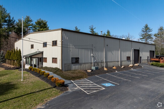
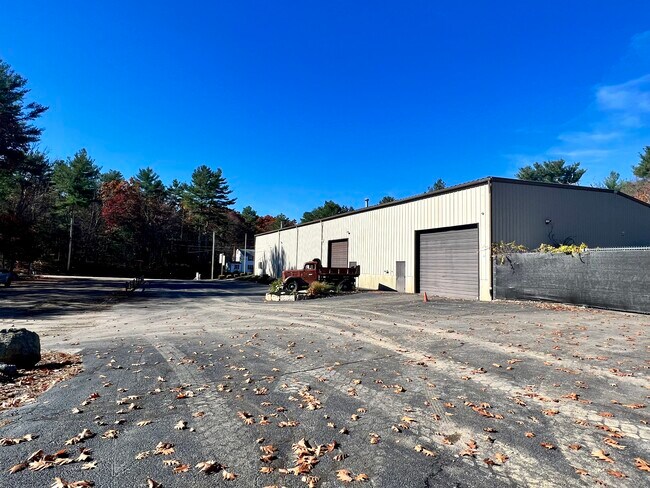
Property Record
116 Davis St, Douglas, MA 01516


Property Detail
116 Davis St
Warehouse
Worcester
IND
Massachusetts
B and X Area of moderate flood hazard, usually the area between the limits of the 100-year and 500-year floods.
1.48 AC
2025
Outlying Worcester
2025
Boston
752101
Worcester, MA
12,600 SF
DOUG-000191-000001
NEARBY LISTINGS FOR SALE OR LEASE
DEMOGRAPHICS near 116 Davis St
1 mile
3 mile
5 mile
2025 Total Population
901
11,461
36,036
2030 Population
920
11,752
37,142
Pop Growth 2025-2030
+ 2.11%
+ 2.54%
+ 3.07%
Average Age
43
43
43
2025 Total Households
339
4,317
13,840
HH Growth 2025-2030
+ 2.06%
+ 2.57%
+ 3.11%
Median Household Inc
$133,631
$134,230
$123,779
Avg Household Size
2.70
2.60
2.60
2025 Avg HH Vehicles
2.00
2.00
2.00
Median Home Value
$452,840
$466,351
$470,774
Median Year Built
1985
1983
1981
Nearby Places
Map Layers
Map Styles
 Street
 Aerial
Layers
 Traffic
 Biking
Places
Listings with unknown addresses are not visible on the map
- Restaurants
- Banks
- Shops
- Fitness
- Groceries
PUBLIC TRANSPORTATION
AIRPORT
Worcester Regional
Drive
Walk
Distance
Worcester Regional
34 min
22.0 mi
Rhode Island Tf Green International
Drive
Walk
Distance
Rhode Island Tf Green International
46 min
32.8 mi
Freight Ports
Port of Davisville, RI
Drive
Walk
Distance
Port of Davisville, RI
60 min
44.7 mi
SALE & LEASE HISTORY
LISTING DATE
SALE/LEASE

Nov 02, 2022
For Sale
Jan 31, 2024
For Sale
Jan 22, 2024
For Lease
Dec 06, 2022
For Lease
Aug 04, 2022
For Lease
Apr 17, 2023
For Sale
Nearby Properties
Address
Land Use
TOTAL SIZE
Lot Size
Zoning
Address
Land Use
TOTAL SIZE
Lot Size
Zoning
450,800 SF
56.41 AC
I
Address
Land Use
TOTAL SIZE
Lot Size
Zoning
607,486 SF
69.67 AC
AG
Address
Land Use
TOTAL SIZE
Lot Size
Zoning
134,096 SF
61.68 AC
C
Address
Land Use
TOTAL SIZE
Lot Size
Zoning
6,743 SF
7.12 AC
IND
Address
Land Use
TOTAL SIZE
Lot Size
Zoning
216,167 SF
26.06 AC
C
Address
Land Use
TOTAL SIZE
Lot Size
Zoning
607,486 SF
31.09 AC
OLI
Address
Land Use
TOTAL SIZE
Lot Size
Zoning
312,077 SF
13.66 AC
C
Address
Land Use
TOTAL SIZE
Lot Size
Zoning
116,864 SF
16.87 AC
OLI
Address
Land Use
TOTAL SIZE
Lot Size
Zoning
75,977 SF
12.90 AC
RB
Address
Land Use
TOTAL SIZE
Lot Size
Zoning
32,156 SF
3.59 AC
VR
Address
Land Use
TOTAL SIZE
Lot Size
Zoning
119,200 SF
16.15 AC
I
Address
Land Use
TOTAL SIZE
Lot Size
Zoning
93,424 SF
6.90 AC
I
Address
Land Use
TOTAL SIZE
Lot Size
Zoning
134,072 SF
8.27 AC
VB
Address
Land Use
TOTAL SIZE
Lot Size
Zoning
607,486 SF
3.84 AC
IND
Address
Land Use
TOTAL SIZE
Lot Size
Zoning
25,601 SF
9.26 AC
RB
Address
Land Use
TOTAL SIZE
Lot Size
Zoning
87.37 AC
IND
Address
Land Use
TOTAL SIZE
Lot Size
Zoning
30,742 SF
5.42 AC
CB
Address
Land Use
TOTAL SIZE
Lot Size
Zoning
70,000 SF
5.84 AC
I
Address
Land Use
TOTAL SIZE
Lot Size
Zoning
25,702 SF
7.04 AC
AG
Address
Land Use
TOTAL SIZE
Lot Size
Zoning
117,586 SF
18.85 AC
B
Address
Land Use
TOTAL SIZE
Lot Size
Zoning
13,704 SF
12.91 AC
RB
Address
Land Use
TOTAL SIZE
Lot Size
Zoning
44,740 SF
3.59 AC
I
Address
Land Use
TOTAL SIZE
Lot Size
Zoning
9,323 SF
6.21 AC
AG
Address
Land Use
TOTAL SIZE
Lot Size
Zoning
12,023 SF
10.31 AC
VB
Address
Land Use
TOTAL SIZE
Lot Size
Zoning
11,552 SF
73.09 AC
IND
Address
Land Use
TOTAL SIZE
Lot Size
Zoning
25,347 SF
30.72 AC
RA
Address
Land Use
TOTAL SIZE
Lot Size
Zoning
16,302 SF
1.85 AC
VR
Address
Land Use
TOTAL SIZE
Lot Size
Zoning
16,875 SF
1.90 AC
OLI
Address
Land Use
TOTAL SIZE
Lot Size
Zoning
10,634 SF
0.77 AC
VR
Address
Land Use
TOTAL SIZE
Lot Size
Zoning
10,333 SF
41.91 AC
IND
The World's #1 Commercial Real Estate Marketplace
Connect with us
© 2026 CoStar Group
The information above has been obtained from sources believed reliable. While we do not doubt its accuracy we have not verified it and make no guarantee, warranty or representation about it. It is your responsibility to independently confirm its accuracy and completeness. Any projections, opinions, assumptions, or estimates used are for example only and do not represent the current or future performance of the property. The value of this transaction to you depends on tax and other factors which should be evaluated by your tax, financial, and legal advisors. You and your advisors should conduct a careful, independent investigation of the property to determine to your satisfaction the suitability of the property for your needs.