Property Record
116 E King St, Martinsburg, WV 25401


Save to a Folder
{{folder.Name}}
{{folder.ListingIds.length}} Properties
{{folder.ListingIds.length}} Property
Create a New Folder
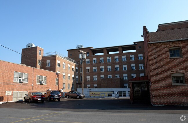
Property Detail
116 E King St
Hagerstown-Martinsburg, MD-WV
.93 AC LOTS 29 & 44 & ADD-ON KINGS DAUGHTERS
06-14-05000000
BERKELEY
Highriseapartments
West Virginia
B and X Area of moderate flood hazard, usually the area between the limits of the 100-year and 500-year floods.
29,44
0
0.93 AC
2025
Berkeley County
971500
Washington, DC
NEARBY LISTINGS FOR SALE OR LEASE
-
-
View all Martinsburg listings for sale on LoopNet.com
DEMOGRAPHICS near 116 E King St
1 mile
3 mile
5 mile
2025 Total Population
13,430
43,244
66,121
2030 Population
14,714
47,114
72,275
Pop Growth 2025-2030
+ 9.56%
+ 8.95%
+ 9.31%
Average Age
39
39
39
2025 Total Households
5,732
17,509
26,119
HH Growth 2025-2030
+ 9.68%
+ 9.05%
+ 9.35%
Median Household Inc
$50,316
$64,297
$71,239
Avg Household Size
2.20
2.40
2.40
2025 Avg HH Vehicles
1.00
2.00
2.00
Median Home Value
$197,963
$243,634
$261,526
Median Year Built
1955
1989
1994
Nearby Places
Map Layers
Map Styles
 Street
 Aerial
Layers
 Traffic
 Biking
Places
Listings with unknown addresses are not visible on the map
- Restaurants
- Banks
- Shops
- Fitness
- Groceries
PUBLIC TRANSPORTATION
COMMUTER RAIL
Martinsburg W Va Marc (BRUNSWICK - WASHINGTON - Maryland Transit Administration)
Drive
Walk
Distance
Martinsburg W Va Marc (BRUNSWICK - WASHINGTON - Maryland Transit Administration)
1 min
5 min
0.3 mi
Martinsburg (Brunswick Line - Maryland Area Regional Commuter Trains (The MARC))
Drive
Walk
Distance
Martinsburg (Brunswick Line - Maryland Area Regional Commuter Trains (The MARC))
1 min
6 min
0.3 mi
AIRPORT
Hagerstown Regional/Richard A Henson Field
Drive
Walk
Distance
Hagerstown Regional/Richard A Henson Field
32 min
24.1 mi
Freight Ports
Port of Baltimore
Drive
Walk
Distance
Port of Baltimore
110 min
93.4 mi
Nearby Properties
Address
Land Use
TOTAL SIZE
Lot Size
Zoning
Address
Land Use
TOTAL SIZE
Lot Size
Zoning
Address
Land Use
TOTAL SIZE
Lot Size
Zoning
18.46 AC
Address
Land Use
TOTAL SIZE
Lot Size
Zoning
849.14 AC
Address
Land Use
TOTAL SIZE
Lot Size
Zoning
Address
Land Use
TOTAL SIZE
Lot Size
Zoning
56.33 AC
Address
Land Use
TOTAL SIZE
Lot Size
Zoning
15.61 AC
Address
Land Use
TOTAL SIZE
Lot Size
Zoning
9.11 AC
Address
Land Use
TOTAL SIZE
Lot Size
Zoning
Address
Land Use
TOTAL SIZE
Lot Size
Zoning
17.02 AC
Address
Land Use
TOTAL SIZE
Lot Size
Zoning
Address
Land Use
TOTAL SIZE
Lot Size
Zoning
18.45 AC
Address
Land Use
TOTAL SIZE
Lot Size
Zoning
8.47 AC
Address
Land Use
TOTAL SIZE
Lot Size
Zoning
4.31 AC
Address
Land Use
TOTAL SIZE
Lot Size
Zoning
Address
Land Use
TOTAL SIZE
Lot Size
Zoning
Address
Land Use
TOTAL SIZE
Lot Size
Zoning
Address
Land Use
TOTAL SIZE
Lot Size
Zoning
5.35 AC
Address
Land Use
TOTAL SIZE
Lot Size
Zoning
Address
Land Use
TOTAL SIZE
Lot Size
Zoning
Address
Land Use
TOTAL SIZE
Lot Size
Zoning
4.40 AC
Address
Land Use
TOTAL SIZE
Lot Size
Zoning
2.46 AC
Address
Land Use
TOTAL SIZE
Lot Size
Zoning
10.74 AC
Address
Land Use
TOTAL SIZE
Lot Size
Zoning
4.40 AC
Address
Land Use
TOTAL SIZE
Lot Size
Zoning
Address
Land Use
TOTAL SIZE
Lot Size
Zoning
0.14 AC
Address
Land Use
TOTAL SIZE
Lot Size
Zoning
6.16 AC
Address
Land Use
TOTAL SIZE
Lot Size
Zoning
2.20 AC
Address
Land Use
TOTAL SIZE
Lot Size
Zoning
16.91 AC
Address
Land Use
TOTAL SIZE
Lot Size
Zoning
Address
Land Use
TOTAL SIZE
Lot Size
Zoning
The World's #1 Commercial Real Estate Marketplace
Connect with us
© 2026 CoStar Group
The information above has been obtained from sources believed reliable. While we do not doubt its accuracy we have not verified it and make no guarantee, warranty or representation about it. It is your responsibility to independently confirm its accuracy and completeness. Any projections, opinions, assumptions, or estimates used are for example only and do not represent the current or future performance of the property. The value of this transaction to you depends on tax and other factors which should be evaluated by your tax, financial, and legal advisors. You and your advisors should conduct a careful, independent investigation of the property to determine to your satisfaction the suitability of the property for your needs.