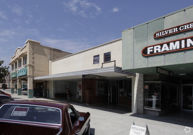
Property Record
116 E Main St, El Cajon, CA 92020


Property Detail
116 E Main St
488-083-09
BLK 1 LOT 2 /EXC HWY/ TR 001070
Storesoffices
San Diego
C-R
California
C and X Area of minimal flood hazard, usually depicted on FIRMs as above the 500-year flood level.
2
2024
0.11 AC
2025
El Cajon
015801
San Diego
5,000 SF
San Diego-Chula Vista-Carlsbad, CA
NEARBY LISTINGS FOR SALE OR LEASE
DEMOGRAPHICS near 116 E Main St
1 mile
3 mile
5 mile
2025 Total Population
40,207
160,018
349,073
2030 Population
40,295
159,932
348,853
Pop Growth 2025-2030
+ 0.22%
(0.05%)
(0.06%)
Average Age
37
39
40
2025 Total Households
13,346
54,704
123,744
HH Growth 2025-2030
+ 0.05%
(0.23%)
(0.20%)
Median Household Inc
$60,460
$81,160
$94,209
Avg Household Size
2.90
2.80
2.70
2025 Avg HH Vehicles
2.00
2.00
2.00
Median Home Value
$614,882
$740,389
$746,342
Median Year Built
1974
1972
1974
Nearby Places
Map Layers
Map Styles
 Street
 Aerial
Layers
 Traffic
 Biking
Places
Listings with unknown addresses are not visible on the map
- Restaurants
- Banks
- Shops
- Fitness
- Groceries
PUBLIC TRANSPORTATION
TRANSIT/SUBWAY
El Cajon Transit Center (Green Line - San Diego Metropolitan Transit System Trolley (San Diego Trolley), Orange Line - San Diego Metropolitan Transit System Trolley (San Diego Trolley))
Drive
Walk
Distance
El Cajon Transit Center (Green Line - San Diego Metropolitan Transit System Trolley (San Diego Trolley), Orange Line - San Diego Metropolitan Transit System Trolley (San Diego Trolley))
4 min
19 min
1.0 mi
AIRPORT
San Diego International
Drive
Walk
Distance
San Diego International
22 min
18.7 mi
Freight Ports
Port of San Diego
Drive
Walk
Distance
Port of San Diego
1 min
13.1 mi
SALE & LEASE HISTORY
LISTING DATE
SALE/LEASE

Jun 11, 2024
For Lease
Nearby Properties
Address
Land Use
TOTAL SIZE
Lot Size
Zoning
Address
Land Use
TOTAL SIZE
Lot Size
Zoning
30.38 AC
RB
Address
Land Use
TOTAL SIZE
Lot Size
Zoning
6.84 AC
M
Address
Land Use
TOTAL SIZE
Lot Size
Zoning
8.24 AC
RU
Address
Land Use
TOTAL SIZE
Lot Size
Zoning
7.46 AC
RM-2200
Address
Land Use
TOTAL SIZE
Lot Size
Zoning
5.90 AC
RM-2200
Address
Land Use
TOTAL SIZE
Lot Size
Zoning
39.17 AC
C-R
Address
Land Use
TOTAL SIZE
Lot Size
Zoning
8.82 AC
RM-2200
Address
Land Use
TOTAL SIZE
Lot Size
Zoning
13.48 AC
CC-1-3
Address
Land Use
TOTAL SIZE
Lot Size
Zoning
6.12 AC
RM-2200
Address
Land Use
TOTAL SIZE
Lot Size
Zoning
Address
Land Use
TOTAL SIZE
Lot Size
Zoning
5.83 AC
RM-2200
Address
Land Use
TOTAL SIZE
Lot Size
Zoning
92,988 SF
6.12 AC
RB
Address
Land Use
TOTAL SIZE
Lot Size
Zoning
9.38 AC
RU
Address
Land Use
TOTAL SIZE
Lot Size
Zoning
5.17 AC
R3
Address
Land Use
TOTAL SIZE
Lot Size
Zoning
85,848 SF
5.03 AC
GC
Address
Land Use
TOTAL SIZE
Lot Size
Zoning
5.77 AC
RM-2200
Address
Land Use
TOTAL SIZE
Lot Size
Zoning
64,900 SF
4.55 AC
RM-2200
Address
Land Use
TOTAL SIZE
Lot Size
Zoning
83,198 SF
5 AC
RM-2200
Address
Land Use
TOTAL SIZE
Lot Size
Zoning
5.45 AC
R14
Address
Land Use
TOTAL SIZE
Lot Size
Zoning
4.39 AC
RM-2200
Address
Land Use
TOTAL SIZE
Lot Size
Zoning
3.80 AC
NC/R14
Address
Land Use
TOTAL SIZE
Lot Size
Zoning
4.75 AC
C-6
Address
Land Use
TOTAL SIZE
Lot Size
Zoning
4.69 AC
RU
Address
Land Use
TOTAL SIZE
Lot Size
Zoning
81,896 SF
3.74 AC
RM-2200
Address
Land Use
TOTAL SIZE
Lot Size
Zoning
95,024 SF
2.89 AC
RM-2200
Address
Land Use
TOTAL SIZE
Lot Size
Zoning
3.51 AC
RM-2200
Address
Land Use
TOTAL SIZE
Lot Size
Zoning
3.33 AC
R22
Address
Land Use
TOTAL SIZE
Lot Size
Zoning
77,930 SF
2.34 AC
O-P
Address
Land Use
TOTAL SIZE
Lot Size
Zoning
16.33 AC
C-R
Address
Land Use
TOTAL SIZE
Lot Size
Zoning
1.89 AC
C-R
The World's #1 Commercial Real Estate Marketplace
Connect with us
© 2026 CoStar Group
The information above has been obtained from sources believed reliable. While we do not doubt its accuracy we have not verified it and make no guarantee, warranty or representation about it. It is your responsibility to independently confirm its accuracy and completeness. Any projections, opinions, assumptions, or estimates used are for example only and do not represent the current or future performance of the property. The value of this transaction to you depends on tax and other factors which should be evaluated by your tax, financial, and legal advisors. You and your advisors should conduct a careful, independent investigation of the property to determine to your satisfaction the suitability of the property for your needs.