Property Record
116 E Robert S Kerr Blvd, Wynnewood, OK 73098
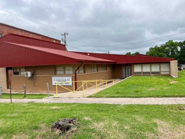


This Property Is For Sale
NEARBY LISTINGS FOR SALE OR LEASE
-
-
View all Wynnewood listings for sale on LoopNet.com
Property Detail
116 E Robert S Kerr Blvd
0145-00-207-001-0-000-00
Wynnewood City
Medicalbuilding
BLOCK 207 WW LOTS 1, 2, 3
X
Garvin
40099C0025C
Oklahoma
2025
1-3
2025
0.64 AC
681500
Oklahoma East Area
8,513 SF
Other Market Areas
DEMOGRAPHICS near 116 E Robert S Kerr Blvd
1 mile
3 mile
5 mile
2024 Total Population
2,051
2,884
3,564
2029 Population
2,102
2,939
3,618
Pop Growth 2024-2029
+ 2.49%
+ 1.91%
+ 1.52%
Average Age
41
41
42
2024 Total Households
833
1,175
1,448
HH Growth 2024-2029
+ 2.40%
+ 1.87%
+ 1.52%
Median Household Inc
$48,749
$49,221
$50,196
Avg Household Size
2.40
2.40
2.40
2024 Avg HH Vehicles
2.00
2.00
2.00
Median Home Value
$94,444
$113,053
$125,466
Median Year Built
1965
1970
1972
Nearby Places
Map Layers
Map Styles
 Street
 Aerial
Transit
 Traffic
 Biking
Places
Listings with unknown addresses are not visible on the map
- Restaurants
- Banks
- Shops
- Fitness
- Groceries
PUBLIC TRANSPORTATION
COMMUTER RAIL
Drive
Walk
Distance
13 min
8.7 mi
Nearby Properties
Address
Land Use
TOTAL SIZE
Lot Size
Zoning
Address
Land Use
TOTAL SIZE
Lot Size
Zoning
18,872 SF
1.98 AC
Address
Land Use
TOTAL SIZE
Lot Size
Zoning
10,904 SF
0.69 AC
C1
Address
Land Use
TOTAL SIZE
Lot Size
Zoning
12,440 SF
1.47 AC
Address
Land Use
TOTAL SIZE
Lot Size
Zoning
1,100 SF
8.96 AC
R1
Address
Land Use
TOTAL SIZE
Lot Size
Zoning
4,189 SF
4.94 AC
C1
Address
Land Use
TOTAL SIZE
Lot Size
Zoning
4,712 SF
1.72 AC
C1
Address
Land Use
TOTAL SIZE
Lot Size
Zoning
2,236 SF
335.13 AC
Address
Land Use
TOTAL SIZE
Lot Size
Zoning
1,650 SF
50 AC
R1
Address
Land Use
TOTAL SIZE
Lot Size
Zoning
2,250 SF
0.35 AC
C1
Address
Land Use
TOTAL SIZE
Lot Size
Zoning
1,260 SF
2.59 AC
Address
Land Use
TOTAL SIZE
Lot Size
Zoning
8,324 SF
0.32 AC
C1
Address
Land Use
TOTAL SIZE
Lot Size
Zoning
3,816 SF
9.90 AC
Address
Land Use
TOTAL SIZE
Lot Size
Zoning
1,225 SF
0.34 AC
C1
Address
Land Use
TOTAL SIZE
Lot Size
Zoning
4,365 SF
0.42 AC
C1
Address
Land Use
TOTAL SIZE
Lot Size
Zoning
9,900 SF
4.80 AC
Address
Land Use
TOTAL SIZE
Lot Size
Zoning
3,072 SF
20 AC
R1
Address
Land Use
TOTAL SIZE
Lot Size
Zoning
3,571 SF
42.50 AC
Address
Land Use
TOTAL SIZE
Lot Size
Zoning
4,672 SF
113.02 AC
NP
Address
Land Use
TOTAL SIZE
Lot Size
Zoning
0.79 AC
Address
Land Use
TOTAL SIZE
Lot Size
Zoning
6,616 SF
1.38 AC
C1
Address
Land Use
TOTAL SIZE
Lot Size
Zoning
4,803 SF
25 AC
NP
Address
Land Use
TOTAL SIZE
Lot Size
Zoning
3,073 SF
434.45 AC
CR
Address
Land Use
TOTAL SIZE
Lot Size
Zoning
8,006 SF
42.69 AC
TM
Address
Land Use
TOTAL SIZE
Lot Size
Zoning
2,045 SF
3.04 AC
R1
Address
Land Use
TOTAL SIZE
Lot Size
Zoning
3,341 SF
30.05 AC
R1
Address
Land Use
TOTAL SIZE
Lot Size
Zoning
3,663 SF
50 AC
NP
Address
Land Use
TOTAL SIZE
Lot Size
Zoning
2,488 SF
77.50 AC
R1
Address
Land Use
TOTAL SIZE
Lot Size
Zoning
2,239 SF
10 AC
Address
Land Use
TOTAL SIZE
Lot Size
Zoning
2,848 SF
2 AC
The World's #1 Commercial Real Estate Marketplace
Connect with us
© 2026 CoStar Group
The information above has been obtained from sources believed reliable. While we do not doubt its accuracy we have not verified it and make no guarantee, warranty or representation about it. It is your responsibility to independently confirm its accuracy and completeness. Any projections, opinions, assumptions, or estimates used are for example only and do not represent the current or future performance of the property. The value of this transaction to you depends on tax and other factors which should be evaluated by your tax, financial, and legal advisors. You and your advisors should conduct a careful, independent investigation of the property to determine to your satisfaction the suitability of the property for your needs.