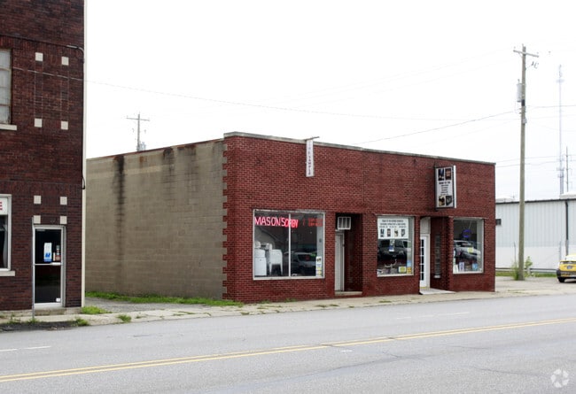
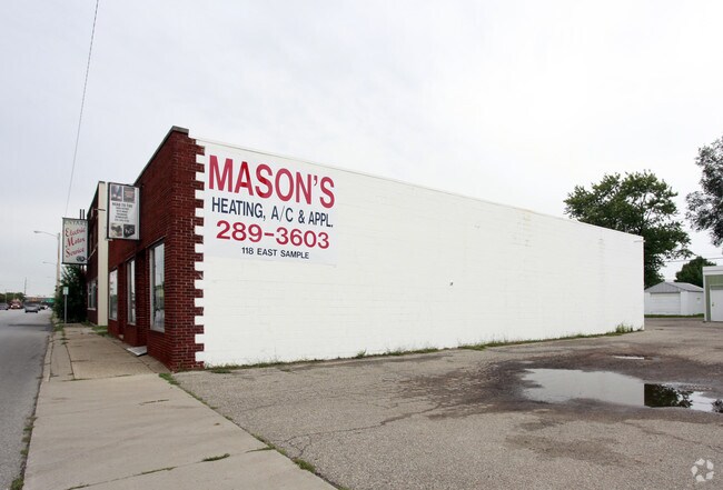
Property Record
116 E Sample St, South Bend, IN 46601

Property Detail
116 E Sample St
71-08-13-126-005.000-026
55 ON SAMPLE ST BEG 202 E MICHIGAN ST ADJ A S BAKERS 1ST ADD & N 1/2 VAC ALLEY S & ADJ SEC 13 37 2E 25/26 VAC ORD #11145-24 11/06/2024
Servicestation
ST JOSEPH
B and X Area of moderate flood hazard, usually the area between the limits of the 100-year and 500-year floods.
Indiana
2024
0.17 AC
2025
Greater South Bend
002900
South Bend/Mishawaka
3,840 SF
South Bend-Mishawaka, IN-MI
NEARBY LISTINGS FOR SALE OR LEASE
DEMOGRAPHICS near 116 E Sample St
1 mile
3 mile
5 mile
2025 Total Population
9,915
99,088
179,511
2030 Population
10,260
101,218
182,456
Pop Growth 2025-2030
+ 3.48%
+ 2.15%
+ 1.64%
Average Age
36
36
38
2025 Total Households
3,954
36,803
71,407
HH Growth 2025-2030
+ 3.54%
+ 2.24%
+ 1.73%
Median Household Inc
$35,024
$53,224
$56,493
Avg Household Size
2.30
2.40
2.30
2025 Avg HH Vehicles
1.00
1.00
2.00
Median Home Value
$136,629
$141,042
$160,125
Median Year Built
1950
1953
1961
Nearby Places
Map Layers
Map Styles
 Street
 Aerial
Transit
 Traffic
 Biking
Places
Listings with unknown addresses are not visible on the map
- Restaurants
- Banks
- Shops
- Fitness
- Groceries
PUBLIC TRANSPORTATION
COMMUTER RAIL
Drive
Walk
Distance
8 min
2.9 mi
South Bend Airport Station (South Shore Line - Northern Indiana Commuter Transportation District (South Shore Line))
Drive
Walk
Distance
South Bend Airport Station (South Shore Line - Northern Indiana Commuter Transportation District (South Shore Line))
13 min
4.7 mi
AIRPORT
South Bend International
Drive
Walk
Distance
South Bend International
22 min
6.9 mi
Nearby Properties
Address
Land Use
TOTAL SIZE
Lot Size
Zoning
Address
Land Use
TOTAL SIZE
Lot Size
Zoning
1,089,534 SF
436.76 AC
Address
Land Use
TOTAL SIZE
Lot Size
Zoning
139,888 SF
12.42 AC
Address
Land Use
TOTAL SIZE
Lot Size
Zoning
82,660 SF
48.07 AC
Address
Land Use
TOTAL SIZE
Lot Size
Zoning
219,803 SF
59.79 AC
Address
Land Use
TOTAL SIZE
Lot Size
Zoning
39,988 SF
21.28 AC
Address
Land Use
TOTAL SIZE
Lot Size
Zoning
61,220 SF
19.80 AC
Address
Land Use
TOTAL SIZE
Lot Size
Zoning
162,985 SF
10.54 AC
Address
Land Use
TOTAL SIZE
Lot Size
Zoning
41,528 SF
6.07 AC
Address
Land Use
TOTAL SIZE
Lot Size
Zoning
41,917 SF
0.93 AC
Address
Land Use
TOTAL SIZE
Lot Size
Zoning
263,706 SF
4.60 AC
Address
Land Use
TOTAL SIZE
Lot Size
Zoning
102,124 SF
75.34 AC
Address
Land Use
TOTAL SIZE
Lot Size
Zoning
10,000 SF
2.57 AC
Address
Land Use
TOTAL SIZE
Lot Size
Zoning
18,213 SF
0.79 AC
Address
Land Use
TOTAL SIZE
Lot Size
Zoning
21,468 SF
1.66 AC
Address
Land Use
TOTAL SIZE
Lot Size
Zoning
55,106 SF
Address
Land Use
TOTAL SIZE
Lot Size
Zoning
120,801 SF
30.51 AC
Address
Land Use
TOTAL SIZE
Lot Size
Zoning
42,485 SF
1.68 AC
Address
Land Use
TOTAL SIZE
Lot Size
Zoning
329,088 SF
47.27 AC
Address
Land Use
TOTAL SIZE
Lot Size
Zoning
50,603 SF
3.14 AC
Address
Land Use
TOTAL SIZE
Lot Size
Zoning
262,531 SF
32.06 AC
Address
Land Use
TOTAL SIZE
Lot Size
Zoning
113,265 SF
2.33 AC
Address
Land Use
TOTAL SIZE
Lot Size
Zoning
2,043 SF
33.65 AC
Address
Land Use
TOTAL SIZE
Lot Size
Zoning
292,085 SF
30.05 AC
Address
Land Use
TOTAL SIZE
Lot Size
Zoning
50,916 SF
11.52 AC
Address
Land Use
TOTAL SIZE
Lot Size
Zoning
102,139 SF
51.29 AC
Address
Land Use
TOTAL SIZE
Lot Size
Zoning
544,872 SF
71.99 AC
Address
Land Use
TOTAL SIZE
Lot Size
Zoning
1,617 SF
2.22 AC
Address
Land Use
TOTAL SIZE
Lot Size
Zoning
38,431 SF
1.58 AC
Address
Land Use
TOTAL SIZE
Lot Size
Zoning
231,450 SF
22.50 AC
Address
Land Use
TOTAL SIZE
Lot Size
Zoning
13,328 SF
96.72 AC
The World's #1 Commercial Real Estate Marketplace
Connect with us
© 2026 CoStar Group
The information above has been obtained from sources believed reliable. While we do not doubt its accuracy we have not verified it and make no guarantee, warranty or representation about it. It is your responsibility to independently confirm its accuracy and completeness. Any projections, opinions, assumptions, or estimates used are for example only and do not represent the current or future performance of the property. The value of this transaction to you depends on tax and other factors which should be evaluated by your tax, financial, and legal advisors. You and your advisors should conduct a careful, independent investigation of the property to determine to your satisfaction the suitability of the property for your needs.