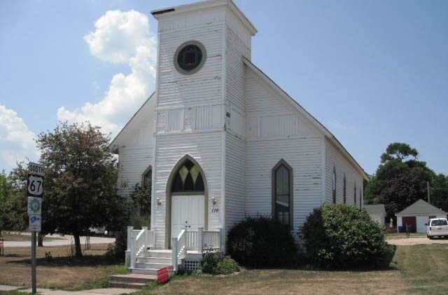
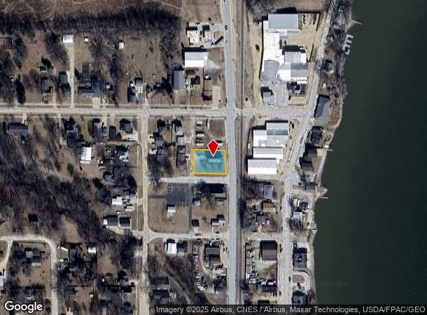
Property Record
116 Highway 67, Princeton, IA 52768
NEARBY LISTINGS FOR SALE OR LEASE
-
-
View all Princeton listings for sale on LoopNet.com
Property Detail
116 Highway 67
Davenport-Moline-Rock Island, IA-IL
Atherton's Add
95023810402
ATHERTON'S ADD LOT: 004 BLOCK: 002 ATHERTON'S ADD TOELIZ. CITY LOTS 3 &
Religious
Scott
X
Iowa
19163C0262G
3
2025
0.30 AC
2025
Outlying Scott County
010101
Davenport/Moline/Rock Island
1,680 SF
DEMOGRAPHICS near 116 Highway 67
1 Mile
3 Mile
5 Mile
2024 Total Population
1,252
2,455
5,554
2029 Population
1,235
2,406
5,413
Pop Growth 2024-2029
(1.36%)
(2.00%)
(2.54%)
Average Age
43
44
44
2024 Total Households
511
1,001
2,256
HH Growth 2024-2029
(1.57%)
(2.10%)
(2.66%)
Median Household Inc
$78,972
$79,888
$83,109
Avg Household Size
2.50
2.40
2.50
2024 Avg HH Vehicles
2.00
2.00
2.00
Median Home Value
$229,310
$238,922
$253,260
Median Year Built
1973
1972
1972
Nearby Places
Map Layers
Map Styles
 Street
 Aerial
- Restaurants
- Banks
- Shops
- Fitness
- Groceries
PUBLIC TRANSPORTATION
AIRPORT
Quad Cities International
DRIVE
WALK
Distance
Quad Cities International
39 min
22.3 mi
Nearby Properties
Address
Land Use
TOTAL SIZE
Lot Size
Zoning
Address
Land Use
TOTAL SIZE
Lot Size
Zoning
30,343 SF
8.31 AC
Address
Land Use
TOTAL SIZE
Lot Size
Zoning
900 SF
27.54 AC
Address
Land Use
TOTAL SIZE
Lot Size
Zoning
20,000 SF
2.44 AC
M
Address
Land Use
TOTAL SIZE
Lot Size
Zoning
2,294 SF
1.13 AC
Address
Land Use
TOTAL SIZE
Lot Size
Zoning
4,539 SF
5 AC
R1
Address
Land Use
TOTAL SIZE
Lot Size
Zoning
2,938 SF
0.65 AC
Address
Land Use
TOTAL SIZE
Lot Size
Zoning
3,896 SF
1.41 AC
Address
Land Use
TOTAL SIZE
Lot Size
Zoning
4.87 AC
COR
Address
Land Use
TOTAL SIZE
Lot Size
Zoning
720 SF
0.57 AC
Address
Land Use
TOTAL SIZE
Lot Size
Zoning
3,000 SF
0.22 AC
Address
Land Use
TOTAL SIZE
Lot Size
Zoning
4,152 SF
27.30 AC
AG2
Address
Land Use
TOTAL SIZE
Lot Size
Zoning
7,382 SF
3.07 AC
Address
Land Use
TOTAL SIZE
Lot Size
Zoning
5,680 SF
4.40 AC
M
Address
Land Use
TOTAL SIZE
Lot Size
Zoning
33 AC
AG
Address
Land Use
TOTAL SIZE
Lot Size
Zoning
2,050 SF
1.10 AC
Address
Land Use
TOTAL SIZE
Lot Size
Zoning
11,970 SF
0.44 AC
Address
Land Use
TOTAL SIZE
Lot Size
Zoning
2,138 SF
0.53 AC
Address
Land Use
TOTAL SIZE
Lot Size
Zoning
2,228 SF
37.70 AC
AG2
Address
Land Use
TOTAL SIZE
Lot Size
Zoning
1,900 SF
0.33 AC
Address
Land Use
TOTAL SIZE
Lot Size
Zoning
7,421 SF
0.20 AC
Address
Land Use
TOTAL SIZE
Lot Size
Zoning
1,482 SF
0.56 AC
Address
Land Use
TOTAL SIZE
Lot Size
Zoning
4,600 SF
0.55 AC
Address
Land Use
TOTAL SIZE
Lot Size
Zoning
3,538 SF
0.31 AC
Address
Land Use
TOTAL SIZE
Lot Size
Zoning
7,520 SF
0.19 AC
Address
Land Use
TOTAL SIZE
Lot Size
Zoning
3,224 SF
0.37 AC
Address
Land Use
TOTAL SIZE
Lot Size
Zoning
5,250 SF
0.34 AC
Address
Land Use
TOTAL SIZE
Lot Size
Zoning
862 SF
44.10 AC
AG2
Address
Land Use
TOTAL SIZE
Lot Size
Zoning
Address
Land Use
TOTAL SIZE
Lot Size
Zoning
497 SF
0.60 AC
Address
Land Use
TOTAL SIZE
Lot Size
Zoning
62.90 AC
The World's #1 Commercial Real Estate Marketplace
Connect with us
© 2026 CoStar Group
The information above has been obtained from sources believed reliable. While we do not doubt its accuracy we have not verified it and make no guarantee, warranty or representation about it. It is your responsibility to independently confirm its accuracy and completeness. Any projections, opinions, assumptions, or estimates used are for example only and do not represent the current or future performance of the property. The value of this transaction to you depends on tax and other factors which should be evaluated by your tax, financial, and legal advisors. You and your advisors should conduct a careful, independent investigation of the property to determine to your satisfaction the suitability of the property for your needs.