Property Record
116 Kaylea Ct E, East Peoria, IL 61611

NEARBY LISTINGS FOR SALE OR LEASE
-
-
View all East Peoria listings for sale on LoopNet.com
Property Detail
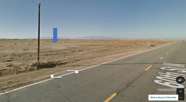
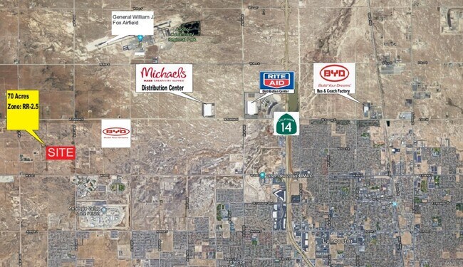
116 Kaylea Ct E
Los Angeles
THAT PART EX OF ST N OF S 10 ACS OF N 1/2 OF SE 1/4 OF SEC 10 T 7N R 13W
Los Angeles-Long Beach-Glendale, CA
Los Angeles
3268-025-001
California
Desertorbarrenland
10
2024
69.81 AC
2025
Antelope Valley
901214
DEMOGRAPHICS near 116 Kaylea Ct E
1 Mile
3 Mile
5 Mile
2024 Total Population
49
15,622
76,082
2029 Population
50
15,296
73,986
Pop Growth 2024-2029
+ 2.04%
(2.09%)
(2.75%)
Average Age
38
36
38
2024 Total Households
17
4,384
24,470
HH Growth 2024-2029
0.00%
(2.33%)
(3.04%)
Median Household Inc
$67,500
$106,409
$87,459
Avg Household Size
2.70
3.40
3.00
2024 Avg HH Vehicles
2.00
3.00
2.00
Median Home Value
$374,999
$445,671
$407,355
Median Year Built
2003
2003
1989
Nearby Places
Map Layers
Map Styles
 Street
 Aerial
- Restaurants
- Banks
- Shops
- Fitness
- Groceries
PUBLIC TRANSPORTATION
AIRPORT
General Downing - Peoria International
DRIVE
WALK
Distance
General Downing - Peoria International
22 min
10.4 mi
Freight Ports
Port Milwaukee
DRIVE
WALK
Distance
Port Milwaukee
274 min
232.9 mi
SALE & LEASE HISTORY
LISTING DATE
SALE/LEASE

Aug 10, 2023
For Sale
Nearby Properties
Address
Land Use
TOTAL SIZE
Lot Size
Zoning
Address
Land Use
TOTAL SIZE
Lot Size
Zoning
85,556 SF
8.46 AC
Address
Land Use
TOTAL SIZE
Lot Size
Zoning
80 SF
14.30 AC
Address
Land Use
TOTAL SIZE
Lot Size
Zoning
161,535 SF
4.76 AC
Address
Land Use
TOTAL SIZE
Lot Size
Zoning
186,472 SF
2.19 AC
Address
Land Use
TOTAL SIZE
Lot Size
Zoning
132.43 AC
Address
Land Use
TOTAL SIZE
Lot Size
Zoning
51,190 SF
3.74 AC
Address
Land Use
TOTAL SIZE
Lot Size
Zoning
135,233 SF
9.85 AC
Address
Land Use
TOTAL SIZE
Lot Size
Zoning
12.12 AC
Address
Land Use
TOTAL SIZE
Lot Size
Zoning
24,318 SF
2.83 AC
Address
Land Use
TOTAL SIZE
Lot Size
Zoning
77,621 SF
4.62 AC
Address
Land Use
TOTAL SIZE
Lot Size
Zoning
219,899 SF
18.53 AC
Address
Land Use
TOTAL SIZE
Lot Size
Zoning
11,499 SF
2.60 AC
Address
Land Use
TOTAL SIZE
Lot Size
Zoning
61,463 SF
45.39 AC
Address
Land Use
TOTAL SIZE
Lot Size
Zoning
13,650 SF
13.77 AC
Address
Land Use
TOTAL SIZE
Lot Size
Zoning
54,120 SF
2.83 AC
Address
Land Use
TOTAL SIZE
Lot Size
Zoning
306,674 SF
11.44 AC
Address
Land Use
TOTAL SIZE
Lot Size
Zoning
313,636 SF
95.83 AC
Address
Land Use
TOTAL SIZE
Lot Size
Zoning
4,404 SF
0.80 AC
Address
Land Use
TOTAL SIZE
Lot Size
Zoning
47,092 SF
1.94 AC
Address
Land Use
TOTAL SIZE
Lot Size
Zoning
90,011 SF
8.35 AC
Address
Land Use
TOTAL SIZE
Lot Size
Zoning
32,648 SF
8.43 AC
Address
Land Use
TOTAL SIZE
Lot Size
Zoning
18,000 SF
1.70 AC
Address
Land Use
TOTAL SIZE
Lot Size
Zoning
208,914 SF
22.25 AC
Address
Land Use
TOTAL SIZE
Lot Size
Zoning
76,064 SF
4.56 AC
Address
Land Use
TOTAL SIZE
Lot Size
Zoning
70,856 SF
6.53 AC
Address
Land Use
TOTAL SIZE
Lot Size
Zoning
253,162 SF
16.04 AC
Address
Land Use
TOTAL SIZE
Lot Size
Zoning
87,189 SF
4.05 AC
Address
Land Use
TOTAL SIZE
Lot Size
Zoning
60,408 SF
52.27 AC
4
Address
Land Use
TOTAL SIZE
Lot Size
Zoning
12,533 SF
1.64 AC
Address
Land Use
TOTAL SIZE
Lot Size
Zoning
54,200 SF
3 AC
The World's #1 Commercial Real Estate Marketplace
Connect with us
© 2025 CoStar Group
The information above has been obtained from sources believed reliable. While we do not doubt its accuracy we have not verified it and make no guarantee, warranty or representation about it. It is your responsibility to independently confirm its accuracy and completeness. Any projections, opinions, assumptions, or estimates used are for example only and do not represent the current or future performance of the property. The value of this transaction to you depends on tax and other factors which should be evaluated by your tax, financial, and legal advisors. You and your advisors should conduct a careful, independent investigation of the property to determine to your satisfaction the suitability of the property for your needs.