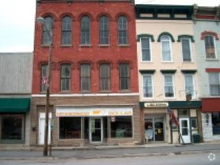
Property Record
116 Main St, Waterville, NY 13480

Save to a Folder
{{folder.Name}}
{{folder.ListingIds.length}} Properties
{{folder.ListingIds.length}} Property
Create a New Folder
Property Detail
116 Main St
392-006-0002-029-000-0000
MAIN ST 21X78 N CREEK E D MOORE S MAIN W MC LAUGHLIN
Commercialofficeresidentialmixeduse
ONEIDA
AE The base floodplain where base flood elevations are provided. AE Zones are now used on new format FIRMs instead of A1-A30 Zones.
New York
2025
29.000
2025
Outlying Oneida County
025700
Utica/Rome
4,698 SF
Utica-Rome, NY
NEARBY LISTINGS FOR SALE OR LEASE
-
-
View all Waterville listings for sale on LoopNet.com
DEMOGRAPHICS near 116 Main St
1 mile
3 mile
5 mile
2025 Total Population
1,625
2,645
4,944
2030 Population
1,605
2,610
4,877
Pop Growth 2025-2030
(1.23%)
(1.32%)
(1.36%)
Average Age
43
43
43
2025 Total Households
681
1,094
2,062
HH Growth 2025-2030
(1.32%)
(1.46%)
(1.36%)
Median Household Inc
$79,977
$80,695
$75,931
Avg Household Size
2.30
2.40
2.30
2025 Avg HH Vehicles
2.00
2.00
2.00
Median Home Value
$183,689
$190,766
$183,048
Median Year Built
1947
1947
1948
Nearby Places
Map Layers
Map Styles
 Street
 Aerial
Layers
 Traffic
 Biking
Places
Listings with unknown addresses are not visible on the map
- Restaurants
- Banks
- Shops
- Fitness
- Groceries
Nearby Properties
Address
Land Use
TOTAL SIZE
Lot Size
Zoning
Address
Land Use
TOTAL SIZE
Lot Size
Zoning
95,124 SF
33 AC
Address
Land Use
TOTAL SIZE
Lot Size
Zoning
59,006 SF
9.30 AC
01 - NOT Z
Address
Land Use
TOTAL SIZE
Lot Size
Zoning
116.97 AC
05 - COMME
Address
Land Use
TOTAL SIZE
Lot Size
Zoning
113,400 SF
16.51 AC
01 - NOT Z
Address
Land Use
TOTAL SIZE
Lot Size
Zoning
32,539 SF
10.60 AC
Address
Land Use
TOTAL SIZE
Lot Size
Zoning
8,060 SF
2.68 AC
01 - NOT Z
Address
Land Use
TOTAL SIZE
Lot Size
Zoning
65,400 SF
2.71 AC
Address
Land Use
TOTAL SIZE
Lot Size
Zoning
Address
Land Use
TOTAL SIZE
Lot Size
Zoning
6,164 SF
Address
Land Use
TOTAL SIZE
Lot Size
Zoning
6,992 SF
Address
Land Use
TOTAL SIZE
Lot Size
Zoning
14,000 SF
8 AC
03 - MULTI
Address
Land Use
TOTAL SIZE
Lot Size
Zoning
Address
Land Use
TOTAL SIZE
Lot Size
Zoning
Address
Land Use
TOTAL SIZE
Lot Size
Zoning
20,556 SF
1.87 AC
Address
Land Use
TOTAL SIZE
Lot Size
Zoning
2.49 AC
05 - COMME
Address
Land Use
TOTAL SIZE
Lot Size
Zoning
9,664 SF
0.32 AC
01 - NOT Z
Address
Land Use
TOTAL SIZE
Lot Size
Zoning
2,592 SF
24.65 AC
R
Address
Land Use
TOTAL SIZE
Lot Size
Zoning
9,028 SF
12.80 AC
01 - NOT Z
Address
Land Use
TOTAL SIZE
Lot Size
Zoning
3,400 SF
4.69 AC
01 - NOT Z
Address
Land Use
TOTAL SIZE
Lot Size
Zoning
48,940 SF
10.48 AC
Address
Land Use
TOTAL SIZE
Lot Size
Zoning
10,342 SF
1.40 AC
Address
Land Use
TOTAL SIZE
Lot Size
Zoning
5,705 SF
0.23 AC
Address
Land Use
TOTAL SIZE
Lot Size
Zoning
3,496 SF
0.24 AC
01 - NOT Z
Address
Land Use
TOTAL SIZE
Lot Size
Zoning
54,156 SF
6.57 AC
Address
Land Use
TOTAL SIZE
Lot Size
Zoning
24.73 AC
Address
Land Use
TOTAL SIZE
Lot Size
Zoning
6,120 SF
2 AC
01 - NOT Z
Address
Land Use
TOTAL SIZE
Lot Size
Zoning
4,112 SF
13.58 AC
01 - NOT Z
Address
Land Use
TOTAL SIZE
Lot Size
Zoning
3,825 SF
2.80 AC
Address
Land Use
TOTAL SIZE
Lot Size
Zoning
12,530 SF
5 AC
01 - NOT Z
Address
Land Use
TOTAL SIZE
Lot Size
Zoning
The World's #1 Commercial Real Estate Marketplace
Connect with us
© 2026 CoStar Group
The information above has been obtained from sources believed reliable. While we do not doubt its accuracy we have not verified it and make no guarantee, warranty or representation about it. It is your responsibility to independently confirm its accuracy and completeness. Any projections, opinions, assumptions, or estimates used are for example only and do not represent the current or future performance of the property. The value of this transaction to you depends on tax and other factors which should be evaluated by your tax, financial, and legal advisors. You and your advisors should conduct a careful, independent investigation of the property to determine to your satisfaction the suitability of the property for your needs.