Property Record
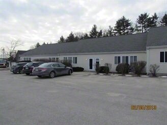
116 Perimeter Rd, Nashua, NH 03063

NEARBY LISTINGS FOR SALE OR LEASE
Property Detail
116 Perimeter Rd
Commercialnec
Hillsborough
X
New Hampshire
33011C0492D
1510
2024
Hillsborough
2024
Boston
010202
Manchester-Nashua, NH
14,604 SF
NASH-000000-001510-L000000-000116E
DEMOGRAPHICS near 116 Perimeter Rd
1 mile
3 mile
5 mile
2024 Total Population
3,443
34,811
106,835
2029 Population
3,543
35,672
109,207
Pop Growth 2024-2029
+ 2.90%
+ 2.47%
+ 2.22%
Average Age
41
43
42
2024 Total Households
1,501
14,579
43,308
HH Growth 2024-2029
+ 3.00%
+ 2.54%
+ 2.25%
Median Household Inc
$102,373
$102,288
$93,996
Avg Household Size
2.20
2.30
2.40
2024 Avg HH Vehicles
2.00
2.00
2.00
Median Home Value
$408,057
$370,017
$369,686
Median Year Built
1983
1979
1975
Nearby Places
Map Layers
Map Styles
 Street
 Aerial
Transit
 Traffic
 Biking
Places
Listings with unknown addresses are not visible on the map
- Restaurants
- Banks
- Shops
- Fitness
- Groceries
PUBLIC TRANSPORTATION
AIRPORT
Manchester Boston Regional
Drive
Walk
Distance
Manchester Boston Regional
27 min
15.4 mi
Freight Ports
Port of Boston
Drive
Walk
Distance
Port of Boston
74 min
52.3 mi
SALE & LEASE HISTORY
LISTING DATE
SALE/LEASE

Jan 07, 2019
For Lease
Nearby Properties
Address
Land Use
TOTAL SIZE
Lot Size
Zoning
Address
Land Use
TOTAL SIZE
Lot Size
Zoning
325.08 AC
AI
Address
Land Use
TOTAL SIZE
Lot Size
Zoning
60.25 AC
PI
Address
Land Use
TOTAL SIZE
Lot Size
Zoning
576,827 SF
446.22 AC
INDUST
Address
Land Use
TOTAL SIZE
Lot Size
Zoning
26.55 AC
INDUST
Address
Land Use
TOTAL SIZE
Lot Size
Zoning
621,927 SF
106.62 AC
INDUST
Address
Land Use
TOTAL SIZE
Lot Size
Zoning
16.12 AC
RC
Address
Land Use
TOTAL SIZE
Lot Size
Zoning
183,432 SF
16.40 AC
GB
Address
Land Use
TOTAL SIZE
Lot Size
Zoning
124,048 SF
23.43 AC
PI
Address
Land Use
TOTAL SIZE
Lot Size
Zoning
66 AC
R18
Address
Land Use
TOTAL SIZE
Lot Size
Zoning
74.50 AC
R9
Address
Land Use
TOTAL SIZE
Lot Size
Zoning
337,000 SF
24.26 AC
PI
Address
Land Use
TOTAL SIZE
Lot Size
Zoning
471,525 SF
28.76 AC
INDUST
Address
Land Use
TOTAL SIZE
Lot Size
Zoning
123,648 SF
135.87 AC
INDUST
Address
Land Use
TOTAL SIZE
Lot Size
Zoning
33.81 AC
PI
Address
Land Use
TOTAL SIZE
Lot Size
Zoning
9.50 AC
AI
Address
Land Use
TOTAL SIZE
Lot Size
Zoning
326,755 SF
43 AC
INDUST
Address
Land Use
TOTAL SIZE
Lot Size
Zoning
130,178 SF
11.07 AC
GB
Address
Land Use
TOTAL SIZE
Lot Size
Zoning
142,207 SF
4.72 AC
PI
Address
Land Use
TOTAL SIZE
Lot Size
Zoning
10.30 AC
RC
Address
Land Use
TOTAL SIZE
Lot Size
Zoning
141,816 SF
21.33 AC
R18
Address
Land Use
TOTAL SIZE
Lot Size
Zoning
9.01 AC
RC
Address
Land Use
TOTAL SIZE
Lot Size
Zoning
8.85 AC
RC
Address
Land Use
TOTAL SIZE
Lot Size
Zoning
8.07 AC
RC
Address
Land Use
TOTAL SIZE
Lot Size
Zoning
8.38 AC
RC
Address
Land Use
TOTAL SIZE
Lot Size
Zoning
52.88 AC
R30
Address
Land Use
TOTAL SIZE
Lot Size
Zoning
140,258 SF
8.02 AC
PI
Address
Land Use
TOTAL SIZE
Lot Size
Zoning
125,916 SF
10.05 AC
GB
Address
Land Use
TOTAL SIZE
Lot Size
Zoning
227,260 SF
35 AC
PI
Address
Land Use
TOTAL SIZE
Lot Size
Zoning
30,406 SF
16.74 AC
INDUST
Address
Land Use
TOTAL SIZE
Lot Size
Zoning
93,448 SF
10 AC
RC
The World's #1 Commercial Real Estate Marketplace
Connect with us
© 2026 CoStar Group
The information above has been obtained from sources believed reliable. While we do not doubt its accuracy we have not verified it and make no guarantee, warranty or representation about it. It is your responsibility to independently confirm its accuracy and completeness. Any projections, opinions, assumptions, or estimates used are for example only and do not represent the current or future performance of the property. The value of this transaction to you depends on tax and other factors which should be evaluated by your tax, financial, and legal advisors. You and your advisors should conduct a careful, independent investigation of the property to determine to your satisfaction the suitability of the property for your needs.