Property Record
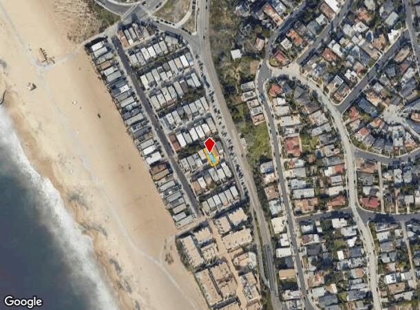
116 Rees St, Playa Del Rey, CA 90293
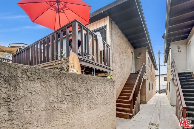
This Property Is For Sale
NEARBY LISTINGS FOR SALE OR LEASE
Property Detail
116 Rees St
Los Angeles-Long Beach-Glendale, CA
8573
4116-033-018
Los Angeles
Duplex
California
X
0.06 AC
06037C1754G
Playa Del Rey
2,328 SF
Los Angeles
DEMOGRAPHICS near 116 Rees St
1 Mile
3 Mile
5 Mile
2024 Total Population
14,484
111,064
332,600
2029 Population
14,495
111,042
332,910
Pop Growth 2024-2029
+ 0.08%
(0.02%)
+ 0.09%
Average Age
44
42
41
2024 Total Households
7,693
53,823
150,082
HH Growth 2024-2029
(0.25%)
(0.22%)
0.00%
Median Household Inc
$133,703
$136,695
$121,044
Avg Household Size
1.90
2.00
2.10
2024 Avg HH Vehicles
2.00
2.00
2.00
Median Home Value
$1,021,493
$1,107,657
$1,103,500
Median Year Built
1975
1977
1970
Nearby Places
- Restaurants
- Banks
- Shops
- Fitness
- Groceries
PUBLIC TRANSPORTATION
AIRPORT
Los Angeles International
DRIVE
WALK
Distance
Los Angeles International
11 min
4.9 mi
Long Beach (Daugherty Field)
DRIVE
WALK
Distance
Long Beach (Daugherty Field)
33 min
22.6 mi
Bob Hope
DRIVE
WALK
Distance
Bob Hope
40 min
26.0 mi
Freight Ports
Port of Long Beach
DRIVE
WALK
Distance
Port of Long Beach
36 min
24.6 mi
Nearby Properties
Address
Land Use
TOTAL SIZE
Lot Size
Zoning
Address
Land Use
TOTAL SIZE
Lot Size
Zoning
514,260 SF
13.76 AC
LAMPV
Address
Land Use
TOTAL SIZE
Lot Size
Zoning
1,007,400 SF
6.45 AC
LAM(PV)
Address
Land Use
TOTAL SIZE
Lot Size
Zoning
512,019 SF
10.70 AC
LAC2(PV)
Address
Land Use
TOTAL SIZE
Lot Size
Zoning
362,414 SF
20.88 AC
LAM1
Address
Land Use
TOTAL SIZE
Lot Size
Zoning
131,967 SF
94.08 AC
LAR4
Address
Land Use
TOTAL SIZE
Lot Size
Zoning
658,463 SF
6.81 AC
LAC2(PV)
Address
Land Use
TOTAL SIZE
Lot Size
Zoning
185,810 SF
13.27 AC
LAM2
Address
Land Use
TOTAL SIZE
Lot Size
Zoning
482,248 SF
5.09 AC
LAR4(PV)
Address
Land Use
TOTAL SIZE
Lot Size
Zoning
321,055 SF
5.98 AC
LAM(PV)
Address
Land Use
TOTAL SIZE
Lot Size
Zoning
9.38 AC
LAR4(PV)
Address
Land Use
TOTAL SIZE
Lot Size
Zoning
322,002 SF
3.88 AC
LARAS4
Address
Land Use
TOTAL SIZE
Lot Size
Zoning
530,988 SF
8 AC
LAM2
Address
Land Use
TOTAL SIZE
Lot Size
Zoning
9.38 AC
LAR4(PV)
Address
Land Use
TOTAL SIZE
Lot Size
Zoning
522,511 SF
4.91 AC
LARAS4
Address
Land Use
TOTAL SIZE
Lot Size
Zoning
392,246 SF
4 AC
LAC4
Address
Land Use
TOTAL SIZE
Lot Size
Zoning
384,621 SF
2.50 AC
LAR4(PV)
Address
Land Use
TOTAL SIZE
Lot Size
Zoning
145,427 SF
2.06 AC
LAC2(PV)
Address
Land Use
TOTAL SIZE
Lot Size
Zoning
284,937 SF
3 AC
LARAS4
Address
Land Use
TOTAL SIZE
Lot Size
Zoning
427,643 SF
5.82 AC
LAC4(OX)
Address
Land Use
TOTAL SIZE
Lot Size
Zoning
152,486 SF
4.78 AC
LAM1
Address
Land Use
TOTAL SIZE
Lot Size
Zoning
214,702 SF
1.51 AC
LAM(PV)
Address
Land Use
TOTAL SIZE
Lot Size
Zoning
347,674 SF
5.65 AC
LAR3
Address
Land Use
TOTAL SIZE
Lot Size
Zoning
261,563 SF
2.53 AC
LAC2(PV)
Address
Land Use
TOTAL SIZE
Lot Size
Zoning
211,675 SF
4.24 AC
LACM(GM)
Address
Land Use
TOTAL SIZE
Lot Size
Zoning
186,187 SF
2.12 AC
LAC2(PV)
Address
Land Use
TOTAL SIZE
Lot Size
Zoning
565,368 SF
4.51 AC
LAC2
Address
Land Use
TOTAL SIZE
Lot Size
Zoning
247,737 SF
3.79 AC
LCR1
Address
Land Use
TOTAL SIZE
Lot Size
Zoning
407,268 SF
6.28 AC
LAC2(PV)
Address
Land Use
TOTAL SIZE
Lot Size
Zoning
7.68 AC
LAM(PV)
Address
Land Use
TOTAL SIZE
Lot Size
Zoning
89,587 SF
1.11 AC
LAM2
The World's #1 Commercial Real Estate Marketplace
Connect with us
© 2025 CoStar Group
The information above has been obtained from sources believed reliable. While we do not doubt its accuracy we have not verified it and make no guarantee, warranty or representation about it. It is your responsibility to independently confirm its accuracy and completeness. Any projections, opinions, assumptions, or estimates used are for example only and do not represent the current or future performance of the property. The value of this transaction to you depends on tax and other factors which should be evaluated by your tax, financial, and legal advisors. You and your advisors should conduct a careful, independent investigation of the property to determine to your satisfaction the suitability of the property for your needs.