Property Record
116 S Crossing Way, Flat Rock, NC 28731
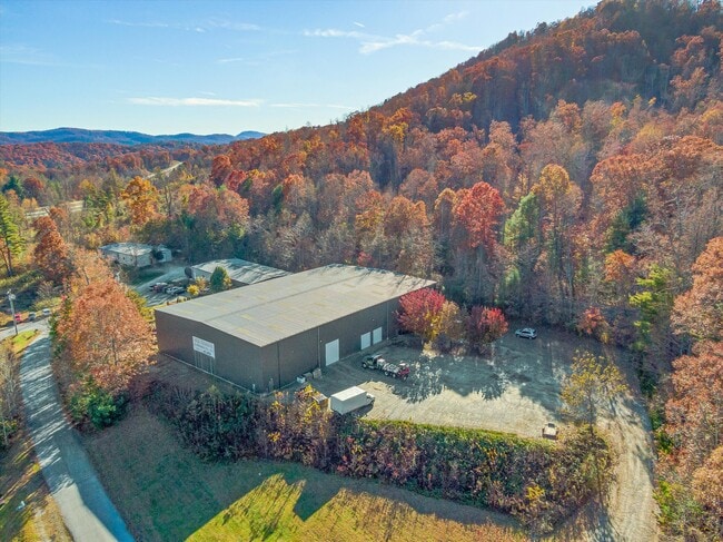


Property Detail
116 S Crossing Way
9962229
OUTH CROSSING BUSINESS PARK LO7 PLSLD-2806
Industrialgeneral
Henderson
9962229~CC
North Carolina
B and X Area of moderate flood hazard, usually the area between the limits of the 100-year and 500-year floods.
3471
2025
1.80 AC
2025
Henderson County
931500
Asheville
16,000 SF
Asheville, NC
NEARBY LISTINGS FOR SALE OR LEASE
DEMOGRAPHICS near 116 S Crossing Way
1 mile
3 mile
5 mile
2025 Total Population
1,536
14,140
32,863
2030 Population
1,582
14,752
34,207
Pop Growth 2025-2030
+ 2.99%
+ 4.33%
+ 4.09%
Average Age
46
46
46
2025 Total Households
634
5,828
13,971
HH Growth 2025-2030
+ 3.15%
+ 4.48%
+ 4.22%
Median Household Inc
$65,250
$64,218
$60,539
Avg Household Size
2.30
2.40
2.30
2025 Avg HH Vehicles
2.00
2.00
2.00
Median Home Value
$299,999
$380,768
$370,627
Median Year Built
1989
1990
1986
Nearby Places
Map Layers
Map Styles
 Street
 Aerial
Transit
 Traffic
 Biking
Places
Listings with unknown addresses are not visible on the map
- Restaurants
- Banks
- Shops
- Fitness
- Groceries
PUBLIC TRANSPORTATION
AIRPORT
Asheville Regional
Drive
Walk
Distance
Asheville Regional
21 min
16.5 mi
Greenville Spartanburg International
Drive
Walk
Distance
Greenville Spartanburg International
52 min
34.8 mi
SALE & LEASE HISTORY
LISTING DATE
SALE/LEASE

Jan 24, 2022
For Lease
Nearby Properties
Address
Land Use
TOTAL SIZE
Lot Size
Zoning
Address
Land Use
TOTAL SIZE
Lot Size
Zoning
5,625 SF
15.53 AC
10007593~P
Address
Land Use
TOTAL SIZE
Lot Size
Zoning
88,500 SF
50.24 AC
9906531~R-
Address
Land Use
TOTAL SIZE
Lot Size
Zoning
44,485 SF
38.89 AC
9906409~OI
Address
Land Use
TOTAL SIZE
Lot Size
Zoning
18.65 AC
10006780~I
Address
Land Use
TOTAL SIZE
Lot Size
Zoning
70,145 SF
31.16 AC
201578~CC
Address
Land Use
TOTAL SIZE
Lot Size
Zoning
516,587 SF
116.84 AC
9928729~I
Address
Land Use
TOTAL SIZE
Lot Size
Zoning
73,500 SF
16.40 AC
10010073~I
Address
Land Use
TOTAL SIZE
Lot Size
Zoning
11.77 AC
10009504~I
Address
Land Use
TOTAL SIZE
Lot Size
Zoning
228,704 SF
10.68 AC
9949735~RC
Address
Land Use
TOTAL SIZE
Lot Size
Zoning
90,495 SF
15.65 AC
10005991~P
Address
Land Use
TOTAL SIZE
Lot Size
Zoning
53,319 SF
1.93 AC
10004263~C
Address
Land Use
TOTAL SIZE
Lot Size
Zoning
46,712 SF
2.12 AC
1016840~PC
Address
Land Use
TOTAL SIZE
Lot Size
Zoning
62,091 SF
12.15 AC
9967364~RC
Address
Land Use
TOTAL SIZE
Lot Size
Zoning
22,699 SF
159.50 AC
1014169~R-
Address
Land Use
TOTAL SIZE
Lot Size
Zoning
45,665 SF
2.86 AC
1011085~C-
Address
Land Use
TOTAL SIZE
Lot Size
Zoning
80,361 SF
3.49 AC
10012676~P
Address
Land Use
TOTAL SIZE
Lot Size
Zoning
49,870 SF
9.84 AC
OI
Address
Land Use
TOTAL SIZE
Lot Size
Zoning
25,750 SF
22.64 AC
200817~CC
Address
Land Use
TOTAL SIZE
Lot Size
Zoning
11,398 SF
23.75 AC
10010923~R
Address
Land Use
TOTAL SIZE
Lot Size
Zoning
33,942 SF
6.38 AC
1013951~RC
Address
Land Use
TOTAL SIZE
Lot Size
Zoning
35,927 SF
4.48 AC
10012678~P
Address
Land Use
TOTAL SIZE
Lot Size
Zoning
65,750 SF
7.52 AC
10001197~I
Address
Land Use
TOTAL SIZE
Lot Size
Zoning
34,458 SF
1.50 AC
9949731~RC
Address
Land Use
TOTAL SIZE
Lot Size
Zoning
37,289 SF
5.11 AC
10009356~C
Address
Land Use
TOTAL SIZE
Lot Size
Zoning
6,900 SF
18.02 AC
114871~R-4
Address
Land Use
TOTAL SIZE
Lot Size
Zoning
7,249 SF
24.56 AC
1017663~R1
Address
Land Use
TOTAL SIZE
Lot Size
Zoning
25,595 SF
6.55 AC
1015602~C-
Address
Land Use
TOTAL SIZE
Lot Size
Zoning
15,052 SF
55.61 AC
10000842~R
Address
Land Use
TOTAL SIZE
Lot Size
Zoning
9,318 SF
15 AC
9963175~I
Address
Land Use
TOTAL SIZE
Lot Size
Zoning
136,732 SF
16.81 AC
106967~I
The World's #1 Commercial Real Estate Marketplace
Connect with us
© 2026 CoStar Group
The information above has been obtained from sources believed reliable. While we do not doubt its accuracy we have not verified it and make no guarantee, warranty or representation about it. It is your responsibility to independently confirm its accuracy and completeness. Any projections, opinions, assumptions, or estimates used are for example only and do not represent the current or future performance of the property. The value of this transaction to you depends on tax and other factors which should be evaluated by your tax, financial, and legal advisors. You and your advisors should conduct a careful, independent investigation of the property to determine to your satisfaction the suitability of the property for your needs.