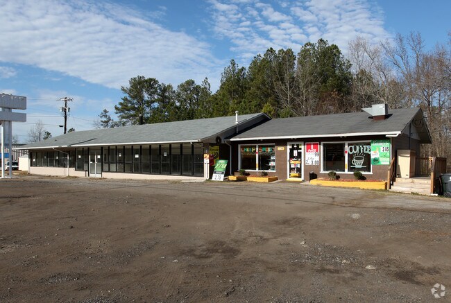
Property Record
116 S Durham Ave, Creedmoor, NC 27522


Save to a Folder
{{folder.Name}}
{{folder.ListingIds.length}} Properties
{{folder.ListingIds.length}} Property
Create a New Folder
Property Detail
116 S Durham Ave
088620824122
LOTS & BLDG US 15
Commercialnec
Granville
B and X Area of moderate flood hazard, usually the area between the limits of the 100-year and 500-year floods.
North Carolina
2025
1.13 AC
2025
North Carolina Northeast Area
970607
Other Market Areas
3,851 SF
NEARBY LISTINGS FOR SALE OR LEASE
-
-
View all Creedmoor listings for lease on LoopNet.com
DEMOGRAPHICS near 116 S Durham Ave
1 mile
3 mile
5 mile
2025 Total Population
1,831
9,393
17,895
2030 Population
1,839
9,486
18,092
Pop Growth 2025-2030
+ 0.44%
+ 0.99%
+ 1.10%
Average Age
40
40
40
2025 Total Households
708
3,629
6,478
HH Growth 2025-2030
+ 0.56%
+ 1.05%
+ 1.11%
Median Household Inc
$67,334
$74,564
$73,394
Avg Household Size
2.60
2.60
2.60
2025 Avg HH Vehicles
2.00
2.00
2.00
Median Home Value
$252,406
$265,009
$259,351
Median Year Built
1992
1995
1993
Nearby Places
Map Layers
Map Styles
 Street
 Aerial
Layers
 Traffic
 Biking
Places
Listings with unknown addresses are not visible on the map
- Restaurants
- Banks
- Shops
- Fitness
- Groceries
PUBLIC TRANSPORTATION
AIRPORT
Raleigh-Durham International
Drive
Walk
Distance
Raleigh-Durham International
35 min
23.7 mi
SALE & LEASE HISTORY
LISTING DATE
SALE/LEASE

Sep 25, 2016
For Lease
Sep 23, 2016
For Sale
Nearby Properties
Address
Land Use
TOTAL SIZE
Lot Size
Zoning
Address
Land Use
TOTAL SIZE
Lot Size
Zoning
2,010 SF
27.95 AC
HBR25
Address
Land Use
TOTAL SIZE
Lot Size
Zoning
159,223 SF
41.40 AC
Address
Land Use
TOTAL SIZE
Lot Size
Zoning
187,800 SF
100.03 AC
I1
Address
Land Use
TOTAL SIZE
Lot Size
Zoning
150,800 SF
35.50 AC
I2HB
Address
Land Use
TOTAL SIZE
Lot Size
Zoning
3,698 SF
16.17 AC
Address
Land Use
TOTAL SIZE
Lot Size
Zoning
81,409 SF
17.20 AC
Address
Land Use
TOTAL SIZE
Lot Size
Zoning
64,031 SF
15.30 AC
Address
Land Use
TOTAL SIZE
Lot Size
Zoning
161,406 SF
25.78 AC
I1
Address
Land Use
TOTAL SIZE
Lot Size
Zoning
182,765 SF
44.18 AC
I1
Address
Land Use
TOTAL SIZE
Lot Size
Zoning
26,919 SF
10.96 AC
Address
Land Use
TOTAL SIZE
Lot Size
Zoning
36,844 SF
8.02 AC
Address
Land Use
TOTAL SIZE
Lot Size
Zoning
40,014 SF
112.70 AC
I2HB
Address
Land Use
TOTAL SIZE
Lot Size
Zoning
144,059 SF
25 AC
I1
Address
Land Use
TOTAL SIZE
Lot Size
Zoning
14,286 SF
18.60 AC
Address
Land Use
TOTAL SIZE
Lot Size
Zoning
62,244 SF
12.66 AC
HB
Address
Land Use
TOTAL SIZE
Lot Size
Zoning
64,202 SF
9.20 AC
HB
Address
Land Use
TOTAL SIZE
Lot Size
Zoning
3,000 SF
5.18 AC
Address
Land Use
TOTAL SIZE
Lot Size
Zoning
157,644 SF
7.44 AC
I1
Address
Land Use
TOTAL SIZE
Lot Size
Zoning
100,000 SF
19.40 AC
WS11GW
Address
Land Use
TOTAL SIZE
Lot Size
Zoning
118,594 SF
39.91 AC
I1
Address
Land Use
TOTAL SIZE
Lot Size
Zoning
107,546 SF
50.30 AC
WSW40
Address
Land Use
TOTAL SIZE
Lot Size
Zoning
617.13 AC
AR40
Address
Land Use
TOTAL SIZE
Lot Size
Zoning
7,873 SF
7.99 AC
HBR25
Address
Land Use
TOTAL SIZE
Lot Size
Zoning
18,972 SF
6.01 AC
CI
Address
Land Use
TOTAL SIZE
Lot Size
Zoning
18,280 SF
5.87 AC
Address
Land Use
TOTAL SIZE
Lot Size
Zoning
19,810 SF
1.96 AC
HBCAII
Address
Land Use
TOTAL SIZE
Lot Size
Zoning
33,758 SF
2.06 AC
CI
Address
Land Use
TOTAL SIZE
Lot Size
Zoning
18,500 SF
10.98 AC
HB
Address
Land Use
TOTAL SIZE
Lot Size
Zoning
18,144 SF
27.25 AC
AR40
Address
Land Use
TOTAL SIZE
Lot Size
Zoning
16,424 SF
3.52 AC
I1
The World's #1 Commercial Real Estate Marketplace
Connect with us
© 2026 CoStar Group
The information above has been obtained from sources believed reliable. While we do not doubt its accuracy we have not verified it and make no guarantee, warranty or representation about it. It is your responsibility to independently confirm its accuracy and completeness. Any projections, opinions, assumptions, or estimates used are for example only and do not represent the current or future performance of the property. The value of this transaction to you depends on tax and other factors which should be evaluated by your tax, financial, and legal advisors. You and your advisors should conduct a careful, independent investigation of the property to determine to your satisfaction the suitability of the property for your needs.