Property Record
116 Scott Dr, Mccomb, MS 39648
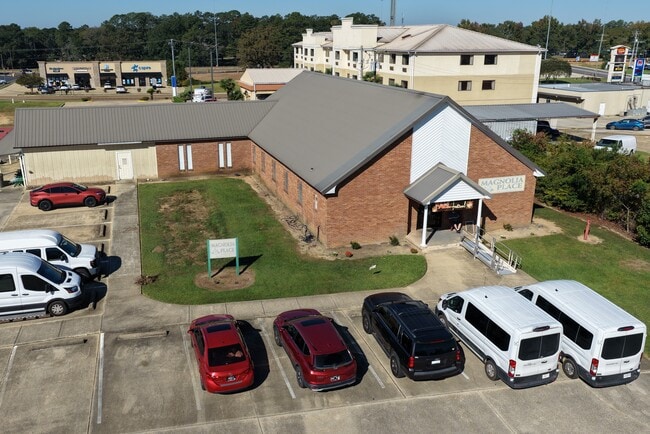


This Property Is For Sale
Property Detail
116 Scott Dr
582588
LOT NW1/4 NW1/4 W SIDE OF SCOTT DR W MCCOMB ZN:X-28113C0101C
Officebuilding
PIKE
C2
Mississippi
B and X Area of moderate flood hazard, usually the area between the limits of the 100-year and 500-year floods.
0.66 AC
2025
Hattiesburg/South Area
2025
Other Market Areas
950501
McComb, MS
6,631 SF
NEARBY LISTINGS FOR SALE OR LEASE
-
-
View all Mccomb listings for sale on LoopNet.com
DEMOGRAPHICS near 116 Scott Dr
1 mile
3 mile
5 mile
2024 Total Population
3,093
15,737
21,438
2029 Population
2,977
15,294
20,823
Pop Growth 2024-2029
(3.75%)
(2.82%)
(2.87%)
Average Age
43
39
39
2024 Total Households
1,328
6,371
8,556
HH Growth 2024-2029
(3.77%)
(2.81%)
(2.84%)
Median Household Inc
$46,250
$41,867
$42,804
Avg Household Size
2.20
2.30
2.40
2024 Avg HH Vehicles
2.00
2.00
2.00
Median Home Value
$141,311
$117,470
$133,439
Median Year Built
1974
1977
1979
Nearby Places
Map Layers
Map Styles
 Street
 Aerial
Transit
 Traffic
 Biking
Places
Listings with unknown addresses are not visible on the map
- Restaurants
- Banks
- Shops
- Fitness
- Groceries
PUBLIC TRANSPORTATION
COMMUTER RAIL
Mccomb (City of New Orleans - Amtrak)
Drive
Walk
Distance
Mccomb (City of New Orleans - Amtrak)
4 min
1.7 mi
Freight Ports
Port of Greater Baton Rouge
Drive
Walk
Distance
Port of Greater Baton Rouge
114 min
99.8 mi
Nearby Properties
Address
Land Use
TOTAL SIZE
Lot Size
Zoning
Address
Land Use
TOTAL SIZE
Lot Size
Zoning
220,645 SF
20.43 AC
CPL
Address
Land Use
TOTAL SIZE
Lot Size
Zoning
70,328 SF
9.12 AC
Address
Land Use
TOTAL SIZE
Lot Size
Zoning
21,390 SF
12.37 AC
Address
Land Use
TOTAL SIZE
Lot Size
Zoning
32,401 SF
6.42 AC
C2
Address
Land Use
TOTAL SIZE
Lot Size
Zoning
7,790 SF
1.23 AC
RPL
Address
Land Use
TOTAL SIZE
Lot Size
Zoning
117,268 SF
14.16 AC
CPL
Address
Land Use
TOTAL SIZE
Lot Size
Zoning
15,508 SF
1.66 AC
SOP
Address
Land Use
TOTAL SIZE
Lot Size
Zoning
1,447 SF
6.17 AC
RPL
Address
Land Use
TOTAL SIZE
Lot Size
Zoning
21,390 SF
6.04 AC
Address
Land Use
TOTAL SIZE
Lot Size
Zoning
49,490 SF
2.36 AC
C2
Address
Land Use
TOTAL SIZE
Lot Size
Zoning
31,976 SF
3.96 AC
BPO
Address
Land Use
TOTAL SIZE
Lot Size
Zoning
1,696 SF
10.20 AC
IPL
Address
Land Use
TOTAL SIZE
Lot Size
Zoning
8,871 SF
1.94 AC
SOM
Address
Land Use
TOTAL SIZE
Lot Size
Zoning
4,721 SF
2.71 AC
Address
Land Use
TOTAL SIZE
Lot Size
Zoning
28,063 SF
4.40 AC
C2
Address
Land Use
TOTAL SIZE
Lot Size
Zoning
110,395 SF
2.48 AC
SCD
Address
Land Use
TOTAL SIZE
Lot Size
Zoning
25,114 SF
4.14 AC
C1
Address
Land Use
TOTAL SIZE
Lot Size
Zoning
48,107 SF
3.80 AC
C1
Address
Land Use
TOTAL SIZE
Lot Size
Zoning
73,961 SF
1.94 AC
CPL
Address
Land Use
TOTAL SIZE
Lot Size
Zoning
187,912 SF
1 AC
CPL
Address
Land Use
TOTAL SIZE
Lot Size
Zoning
32,565 SF
1.49 AC
Address
Land Use
TOTAL SIZE
Lot Size
Zoning
43,457 SF
7.22 AC
RPL
Address
Land Use
TOTAL SIZE
Lot Size
Zoning
5,185 SF
1.10 AC
C2
Address
Land Use
TOTAL SIZE
Lot Size
Zoning
35,177 SF
1.36 AC
C2
Address
Land Use
TOTAL SIZE
Lot Size
Zoning
18,289 SF
5.78 AC
Address
Land Use
TOTAL SIZE
Lot Size
Zoning
7,936 SF
0.70 AC
C1
Address
Land Use
TOTAL SIZE
Lot Size
Zoning
40,597 SF
7.74 AC
C2
Address
Land Use
TOTAL SIZE
Lot Size
Zoning
7,577 SF
0.96 AC
C2
Address
Land Use
TOTAL SIZE
Lot Size
Zoning
17,512 SF
1.33 AC
SCD
Address
Land Use
TOTAL SIZE
Lot Size
Zoning
12,092 SF
12.24 AC
The World's #1 Commercial Real Estate Marketplace
Connect with us
© 2026 CoStar Group
The information above has been obtained from sources believed reliable. While we do not doubt its accuracy we have not verified it and make no guarantee, warranty or representation about it. It is your responsibility to independently confirm its accuracy and completeness. Any projections, opinions, assumptions, or estimates used are for example only and do not represent the current or future performance of the property. The value of this transaction to you depends on tax and other factors which should be evaluated by your tax, financial, and legal advisors. You and your advisors should conduct a careful, independent investigation of the property to determine to your satisfaction the suitability of the property for your needs.